Property Record
Nogal St, San Diego, CA 92102

NEARBY LISTINGS FOR SALE OR LEASE
Property Detail
Nogal St
San Diego-Carlsbad, CA
Parcel Map No 16383
547-313-25
PAR 2 TR PM16383
Residentialacreage
San Diego
AE
California
06073C1904G
0.19 AC
2024
Southeast San Diego
2025
San Diego
004101
DEMOGRAPHICS near Nogal St
1 Mile
3 Mile
5 Mile
2024 Total Population
29,696
250,178
621,813
2029 Population
29,441
247,759
617,896
Pop Growth 2024-2029
(0.86%)
(0.97%)
(0.63%)
Average Age
35
37
38
2024 Total Households
7,972
73,911
226,090
HH Growth 2024-2029
(1.08%)
(1.15%)
(0.58%)
Median Household Inc
$54,150
$63,208
$70,463
Avg Household Size
3.50
3.10
2.60
2024 Avg HH Vehicles
2.00
2.00
2.00
Median Home Value
$468,210
$573,614
$658,488
Median Year Built
1968
1965
1971
Nearby Places
Map Layers
Map Styles
 Street
 Aerial
- Restaurants
- Banks
- Shops
- Fitness
- Groceries
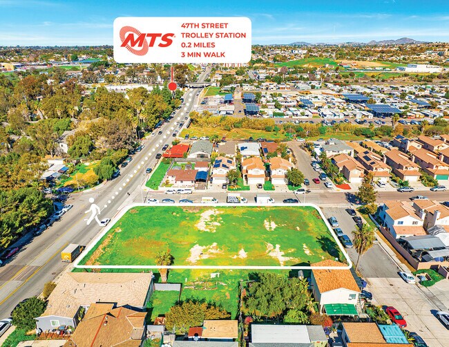
PUBLIC TRANSPORTATION
TRANSIT/SUBWAY
47Th Street (Orange Line - San Diego Metropolitan Transit System Trolley (San Diego Trolley))
DRIVE
WALK
Distance
47Th Street (Orange Line - San Diego Metropolitan Transit System Trolley (San Diego Trolley))
1 min
6 min
0.3 mi
Euclid Avenue (Orange Line - San Diego Metropolitan Transit System Trolley (San Diego Trolley))
DRIVE
WALK
Distance
Euclid Avenue (Orange Line - San Diego Metropolitan Transit System Trolley (San Diego Trolley))
2 min
18 min
1.0 mi
COMMUTER RAIL
San Diego (Santa Fe Depot) (Coaster - San Diego North County Transit District (Coaster/Sprinter/Breeze))
DRIVE
WALK
Distance
San Diego (Santa Fe Depot) (Coaster - San Diego North County Transit District (Coaster/Sprinter/Breeze))
9 min
5.7 mi
Old Town Transit Center (Coaster - San Diego North County Transit District (Coaster/Sprinter/Breeze))
DRIVE
WALK
Distance
Old Town Transit Center (Coaster - San Diego North County Transit District (Coaster/Sprinter/Breeze))
12 min
8.7 mi
AIRPORT
San Diego International
DRIVE
WALK
Distance
San Diego International
12 min
8.1 mi
Freight Ports
Port of San Diego
DRIVE
WALK
Distance
Port of San Diego
10 min
4.3 mi
SALE & LEASE HISTORY
LISTING DATE
SALE/LEASE

Feb 07, 2023
For Sale
Nearby Properties
Address
Land Use
TOTAL SIZE
Lot Size
Zoning
Address
Land Use
TOTAL SIZE
Lot Size
Zoning
125.69 AC
M
Address
Land Use
TOTAL SIZE
Lot Size
Zoning
15.72 AC
RM-2-5
Address
Land Use
TOTAL SIZE
Lot Size
Zoning
12.19 AC
RM-2
Address
Land Use
TOTAL SIZE
Lot Size
Zoning
8.99 AC
IL-2-1
Address
Land Use
TOTAL SIZE
Lot Size
Zoning
10.92 AC
RM-2-5
Address
Land Use
TOTAL SIZE
Lot Size
Zoning
9.62 AC
MXD-2
Address
Land Use
TOTAL SIZE
Lot Size
Zoning
7.47 AC
RS-1-7
Address
Land Use
TOTAL SIZE
Lot Size
Zoning
10.43 AC
RM-2
Address
Land Use
TOTAL SIZE
Lot Size
Zoning
6.07 AC
MXD-1
Address
Land Use
TOTAL SIZE
Lot Size
Zoning
Address
Land Use
TOTAL SIZE
Lot Size
Zoning
4.12 AC
RM-2-5
Address
Land Use
TOTAL SIZE
Lot Size
Zoning
Address
Land Use
TOTAL SIZE
Lot Size
Zoning
0.68 AC
MXU
Address
Land Use
TOTAL SIZE
Lot Size
Zoning
66,488 SF
4.77 AC
RM-1-1
Address
Land Use
TOTAL SIZE
Lot Size
Zoning
3,274 SF
8.58 AC
RM-2-5
Address
Land Use
TOTAL SIZE
Lot Size
Zoning
0.89 AC
MXU
Address
Land Use
TOTAL SIZE
Lot Size
Zoning
76,798 SF
7.21 AC
I
Address
Land Use
TOTAL SIZE
Lot Size
Zoning
Address
Land Use
TOTAL SIZE
Lot Size
Zoning
79,463 SF
1.03 AC
MXC-2
Address
Land Use
TOTAL SIZE
Lot Size
Zoning
14.62 AC
MXD-2
Address
Land Use
TOTAL SIZE
Lot Size
Zoning
6.53 AC
IL-3-1
Address
Land Use
TOTAL SIZE
Lot Size
Zoning
6.16 AC
CC-2-3
Address
Land Use
TOTAL SIZE
Lot Size
Zoning
37,831 SF
5.58 AC
CUPD-CU-2-
Address
Land Use
TOTAL SIZE
Lot Size
Zoning
98,715 SF
0.66 AC
ROW
Address
Land Use
TOTAL SIZE
Lot Size
Zoning
39,600 SF
1.98 AC
RM-3
Address
Land Use
TOTAL SIZE
Lot Size
Zoning
Address
Land Use
TOTAL SIZE
Lot Size
Zoning
12.55 AC
CC-2-3
Address
Land Use
TOTAL SIZE
Lot Size
Zoning
66,284 SF
1.52 AC
CUPD-CU-2-
Address
Land Use
TOTAL SIZE
Lot Size
Zoning
4.34 AC
BLPD-REDEV
Address
Land Use
TOTAL SIZE
Lot Size
Zoning
69,865 SF
2.20 AC
C
The World's #1 Commercial Real Estate Marketplace
Connect with us
© 2025 CoStar Group
The information above has been obtained from sources believed reliable. While we do not doubt its accuracy we have not verified it and make no guarantee, warranty or representation about it. It is your responsibility to independently confirm its accuracy and completeness. Any projections, opinions, assumptions, or estimates used are for example only and do not represent the current or future performance of the property. The value of this transaction to you depends on tax and other factors which should be evaluated by your tax, financial, and legal advisors. You and your advisors should conduct a careful, independent investigation of the property to determine to your satisfaction the suitability of the property for your needs.