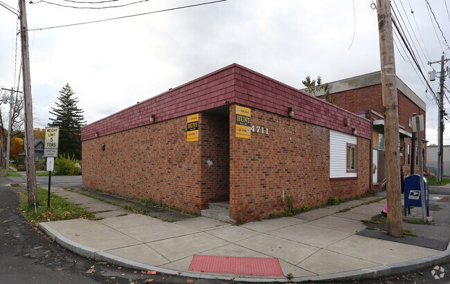
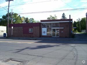
Property Record
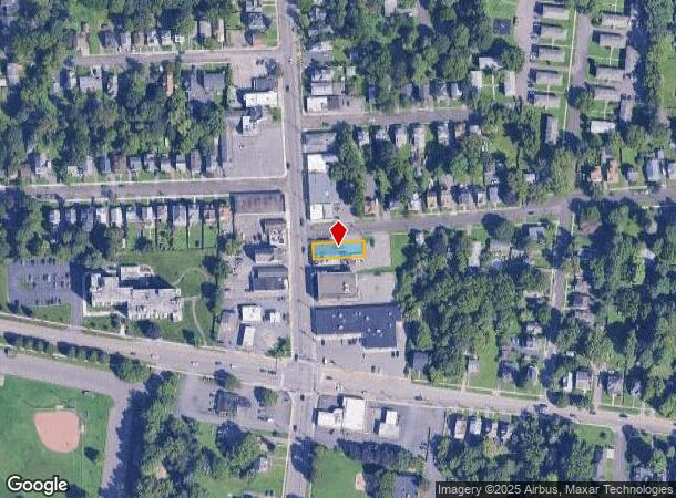
4709 S Salina St, Syracuse, NY 13205
NEARBY LISTINGS FOR SALE OR LEASE
Property Detail
4709 S Salina St
311500-071-000-0017-020-000-0000
LOT P19 TR FREDK FL12O 38.5OX132 BR BLDG FP 72
Officebuilding
Onondaga
X
New York
36067C0219F
20.000
2025
0.12 AC
2024
Greater Syracuse
006101
Syracuse
2,220 SF
Syracuse, NY
DEMOGRAPHICS near 4709 S Salina St
1 Mile
3 Mile
5 Mile
2024 Total Population
13,561
79,124
177,946
2029 Population
13,318
77,860
174,170
Pop Growth 2024-2029
(1.79%)
(1.60%)
(2.12%)
Average Age
43
37
38
2024 Total Households
5,799
28,426
71,019
HH Growth 2024-2029
(1.83%)
(1.65%)
(2.15%)
Median Household Inc
$37,638
$44,174
$47,684
Avg Household Size
2.10
2.30
2.20
2024 Avg HH Vehicles
1.00
1.00
1.00
Median Home Value
$90,007
$146,409
$156,398
Median Year Built
1958
1955
1952
Nearby Places
- Restaurants
- Banks
- Shops
- Fitness
- Groceries
PUBLIC TRANSPORTATION
AIRPORT
Syracuse Hancock International
DRIVE
WALK
Distance
Syracuse Hancock International
16 min
10.7 mi
Freight Ports
Albany, NY Port
DRIVE
WALK
Distance
Albany, NY Port
1 min
123.6 mi
Nearby Properties
Address
Land Use
TOTAL SIZE
Lot Size
Zoning
Address
Land Use
TOTAL SIZE
Lot Size
Zoning
70,284 SF
74.57 AC
25
Address
Land Use
TOTAL SIZE
Lot Size
Zoning
459,040 SF
4.71 AC
06 - INDUS
Address
Land Use
TOTAL SIZE
Lot Size
Zoning
12.08 AC
Address
Land Use
TOTAL SIZE
Lot Size
Zoning
826,528 SF
2.28 AC
06 - INDUS
Address
Land Use
TOTAL SIZE
Lot Size
Zoning
269,030 SF
11.90 AC
05 - COMME
Address
Land Use
TOTAL SIZE
Lot Size
Zoning
412,577 SF
39.43 AC
08 - GOVER
Address
Land Use
TOTAL SIZE
Lot Size
Zoning
348,998 SF
65.59 AC
25
Address
Land Use
TOTAL SIZE
Lot Size
Zoning
72,200 SF
12.39 AC
06 - INDUS
Address
Land Use
TOTAL SIZE
Lot Size
Zoning
354,492 SF
6.90 AC
25
Address
Land Use
TOTAL SIZE
Lot Size
Zoning
72,800 SF
1.89 AC
06 - INDUS
Address
Land Use
TOTAL SIZE
Lot Size
Zoning
218,051 SF
2.32 AC
25
Address
Land Use
TOTAL SIZE
Lot Size
Zoning
24,360 SF
3.99 AC
10
Address
Land Use
TOTAL SIZE
Lot Size
Zoning
108,368 SF
3.36 AC
14
Address
Land Use
TOTAL SIZE
Lot Size
Zoning
2,709 SF
39.74 AC
06 - INDUS
Address
Land Use
TOTAL SIZE
Lot Size
Zoning
1.67 AC
06 - INDUS
Address
Land Use
TOTAL SIZE
Lot Size
Zoning
165,800 SF
1.27 AC
25
Address
Land Use
TOTAL SIZE
Lot Size
Zoning
164,837 SF
0.66 AC
10
Address
Land Use
TOTAL SIZE
Lot Size
Zoning
105,004 SF
2.81 AC
25
Address
Land Use
TOTAL SIZE
Lot Size
Zoning
168,000 SF
2.18 AC
06 - INDUS
Address
Land Use
TOTAL SIZE
Lot Size
Zoning
307,860 SF
1.17 AC
25
Address
Land Use
TOTAL SIZE
Lot Size
Zoning
6,400 SF
86.36 AC
06 - INDUS
Address
Land Use
TOTAL SIZE
Lot Size
Zoning
50,472 SF
4.89 AC
10
Address
Land Use
TOTAL SIZE
Lot Size
Zoning
31,947 SF
1.23 AC
Address
Land Use
TOTAL SIZE
Lot Size
Zoning
278,208 SF
1.92 AC
25
Address
Land Use
TOTAL SIZE
Lot Size
Zoning
134,400 SF
1.18 AC
25
Address
Land Use
TOTAL SIZE
Lot Size
Zoning
172,600 SF
3.19 AC
06 - INDUS
Address
Land Use
TOTAL SIZE
Lot Size
Zoning
25,646 SF
88.85 AC
02 - SINGL
Address
Land Use
TOTAL SIZE
Lot Size
Zoning
168,067 SF
25
Address
Land Use
TOTAL SIZE
Lot Size
Zoning
92,724 SF
2.98 AC
25
Address
Land Use
TOTAL SIZE
Lot Size
Zoning
74,700 SF
3.64 AC
25
The World's #1 Commercial Real Estate Marketplace
Connect with us
© 2025 CoStar Group
The information above has been obtained from sources believed reliable. While we do not doubt its accuracy we have not verified it and make no guarantee, warranty or representation about it. It is your responsibility to independently confirm its accuracy and completeness. Any projections, opinions, assumptions, or estimates used are for example only and do not represent the current or future performance of the property. The value of this transaction to you depends on tax and other factors which should be evaluated by your tax, financial, and legal advisors. You and your advisors should conduct a careful, independent investigation of the property to determine to your satisfaction the suitability of the property for your needs.