Property Record
471 10Th St E, Ketchum, ID 83340
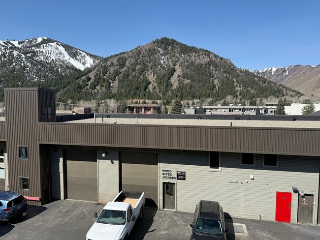


This Property Is For Sale
Property Detail
471 10Th St E
RPK0953-00B-0080
TENTH ST LIGHT INDUST COMPLEX BLDG B UNIT 8 0.046
Commercialnec
BLAINE
B and X Area of moderate flood hazard, usually the area between the limits of the 100-year and 500-year floods.
Idaho
2025
0.17 AC
2025
Idaho South Area
960301
Other Market Areas
3,191 SF
Hailey, ID
NEARBY LISTINGS FOR SALE OR LEASE
-
-
View all Ketchum listings for sale on LoopNet.com
DEMOGRAPHICS near 471 10Th St E
1 mile
3 mile
5 mile
2025 Total Population
2,268
5,399
5,484
2030 Population
2,313
5,488
5,569
Pop Growth 2025-2030
+ 1.98%
+ 1.65%
+ 1.55%
Average Age
47
48
48
2025 Total Households
1,225
2,769
2,810
HH Growth 2025-2030
+ 2.04%
+ 1.66%
+ 1.60%
Median Household Inc
$80,967
$81,028
$81,663
Avg Household Size
1.80
1.90
1.90
2025 Avg HH Vehicles
2.00
2.00
2.00
Median Home Value
$798,165
$809,500
$811,428
Median Year Built
1978
1981
1981
Nearby Places
Map Layers
Map Styles
 Street
 Aerial
Layers
 Traffic
 Biking
Places
Listings with unknown addresses are not visible on the map
- Restaurants
- Banks
- Shops
- Fitness
- Groceries
PUBLIC TRANSPORTATION
AIRPORT
Friedman Memorial
Drive
Walk
Distance
Friedman Memorial
20 min
13.8 mi
Freight Ports
Port of Portland
Drive
Walk
Distance
Port of Portland
650 min
582.9 mi
Nearby Properties
Address
Land Use
TOTAL SIZE
Lot Size
Zoning
Address
Land Use
TOTAL SIZE
Lot Size
Zoning
19,807 SF
27.67 AC
Address
Land Use
TOTAL SIZE
Lot Size
Zoning
67,553 SF
0.47 AC
Address
Land Use
TOTAL SIZE
Lot Size
Zoning
1,181 SF
125.33 AC
Address
Land Use
TOTAL SIZE
Lot Size
Zoning
56,348 SF
1.11 AC
Address
Land Use
TOTAL SIZE
Lot Size
Zoning
40,640 SF
0.83 AC
Address
Land Use
TOTAL SIZE
Lot Size
Zoning
25.12 AC
Address
Land Use
TOTAL SIZE
Lot Size
Zoning
15,791 SF
57.37 AC
Address
Land Use
TOTAL SIZE
Lot Size
Zoning
35,479 SF
1.22 AC
Address
Land Use
TOTAL SIZE
Lot Size
Zoning
20.56 AC
Address
Land Use
TOTAL SIZE
Lot Size
Zoning
26,814 SF
1.42 AC
Address
Land Use
TOTAL SIZE
Lot Size
Zoning
4,749 SF
Address
Land Use
TOTAL SIZE
Lot Size
Zoning
16,474 SF
1.49 AC
Address
Land Use
TOTAL SIZE
Lot Size
Zoning
15.53 AC
Address
Land Use
TOTAL SIZE
Lot Size
Zoning
25,269 SF
0.58 AC
Address
Land Use
TOTAL SIZE
Lot Size
Zoning
4,488 SF
Address
Land Use
TOTAL SIZE
Lot Size
Zoning
20,709 SF
0.25 AC
Address
Land Use
TOTAL SIZE
Lot Size
Zoning
15,016 SF
0.44 AC
Address
Land Use
TOTAL SIZE
Lot Size
Zoning
1.41 AC
Address
Land Use
TOTAL SIZE
Lot Size
Zoning
13.63 AC
Address
Land Use
TOTAL SIZE
Lot Size
Zoning
10,725 SF
0.25 AC
Address
Land Use
TOTAL SIZE
Lot Size
Zoning
13,031 SF
0.61 AC
Address
Land Use
TOTAL SIZE
Lot Size
Zoning
1.01 AC
Address
Land Use
TOTAL SIZE
Lot Size
Zoning
10,164 SF
0.27 AC
Address
Land Use
TOTAL SIZE
Lot Size
Zoning
Address
Land Use
TOTAL SIZE
Lot Size
Zoning
5,459 SF
0.92 AC
Address
Land Use
TOTAL SIZE
Lot Size
Zoning
8.68 AC
Address
Land Use
TOTAL SIZE
Lot Size
Zoning
5.95 AC
Address
Land Use
TOTAL SIZE
Lot Size
Zoning
8,776 SF
0.21 AC
Address
Land Use
TOTAL SIZE
Lot Size
Zoning
29,524 SF
1.03 AC
Address
Land Use
TOTAL SIZE
Lot Size
Zoning
0.72 AC
The World's #1 Commercial Real Estate Marketplace
Connect with us
© 2026 CoStar Group
The information above has been obtained from sources believed reliable. While we do not doubt its accuracy we have not verified it and make no guarantee, warranty or representation about it. It is your responsibility to independently confirm its accuracy and completeness. Any projections, opinions, assumptions, or estimates used are for example only and do not represent the current or future performance of the property. The value of this transaction to you depends on tax and other factors which should be evaluated by your tax, financial, and legal advisors. You and your advisors should conduct a careful, independent investigation of the property to determine to your satisfaction the suitability of the property for your needs.