Property Record
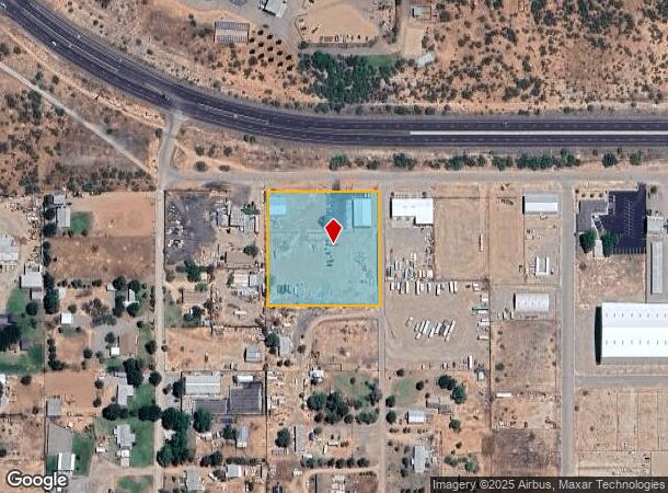
471 E Howards Rd, Camp Verde, AZ 86322
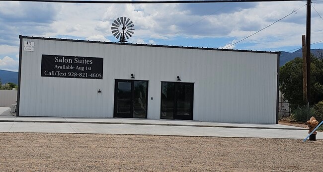

Current Lease Availabilities
Property Detail
471 E Howards Rd
404-02-106A
A M&B PTN OF THE NE4NE4NE4SW4 NE PCL COR IS C4 COR SEC 5-13-5E SE C 5-13-5E CONT 2.5AC
Commercialnec
Yavapai
X
Arizona
04025C2186H
2.50 AC
2024
Prescott & Sedona
2026
Other Market Areas
001602
Prescott, AZ
6,541 SF
NEARBY LISTINGS FOR SALE OR LEASE
DEMOGRAPHICS near 471 E Howards Rd
1 mile
3 mile
5 mile
2024 Total Population
1,228
6,441
11,537
2029 Population
1,411
7,450
13,324
Pop Growth 2024-2029
+ 14.90%
+ 15.67%
+ 15.49%
Average Age
47
46
46
2024 Total Households
509
2,687
4,708
HH Growth 2024-2029
+ 15.13%
+ 16.00%
+ 15.85%
Median Household Inc
$71,249
$58,432
$59,093
Avg Household Size
2.40
2.40
2.40
2024 Avg HH Vehicles
3.00
2.00
2.00
Median Home Value
$432,812
$373,376
$328,034
Median Year Built
1987
1992
1990
Nearby Places
Map Layers
Map Styles
 Street
 Aerial
Transit
 Traffic
 Biking
Places
Listings with unknown addresses are not visible on the map
- Restaurants
- Banks
- Shops
- Fitness
- Groceries
Nearby Properties
Address
Land Use
TOTAL SIZE
Lot Size
Zoning
Address
Land Use
TOTAL SIZE
Lot Size
Zoning
168,228 SF
30.29 AC
Address
Land Use
TOTAL SIZE
Lot Size
Zoning
78,554 SF
15.25 AC
Address
Land Use
TOTAL SIZE
Lot Size
Zoning
24,365 SF
29.39 AC
Address
Land Use
TOTAL SIZE
Lot Size
Zoning
51,384 SF
4.17 AC
Address
Land Use
TOTAL SIZE
Lot Size
Zoning
56,576 SF
2.50 AC
Address
Land Use
TOTAL SIZE
Lot Size
Zoning
23,400 SF
10.09 AC
Address
Land Use
TOTAL SIZE
Lot Size
Zoning
1,538 SF
16.58 AC
Address
Land Use
TOTAL SIZE
Lot Size
Zoning
49,938 SF
6.66 AC
Address
Land Use
TOTAL SIZE
Lot Size
Zoning
164 SF
36.05 AC
Address
Land Use
TOTAL SIZE
Lot Size
Zoning
39,699 SF
3.80 AC
Address
Land Use
TOTAL SIZE
Lot Size
Zoning
40,342 SF
2.83 AC
Address
Land Use
TOTAL SIZE
Lot Size
Zoning
10,050 SF
5.48 AC
Address
Land Use
TOTAL SIZE
Lot Size
Zoning
31,752 SF
2.43 AC
Address
Land Use
TOTAL SIZE
Lot Size
Zoning
37,780 SF
6.66 AC
Address
Land Use
TOTAL SIZE
Lot Size
Zoning
23,109 SF
3.77 AC
Address
Land Use
TOTAL SIZE
Lot Size
Zoning
14,978 SF
4.79 AC
Address
Land Use
TOTAL SIZE
Lot Size
Zoning
44,866 SF
2.40 AC
Address
Land Use
TOTAL SIZE
Lot Size
Zoning
40,237 SF
1.93 AC
Address
Land Use
TOTAL SIZE
Lot Size
Zoning
28,134 SF
1.67 AC
Address
Land Use
TOTAL SIZE
Lot Size
Zoning
52,662 SF
14.43 AC
Address
Land Use
TOTAL SIZE
Lot Size
Zoning
88 SF
22.63 AC
Address
Land Use
TOTAL SIZE
Lot Size
Zoning
9,159 SF
1.12 AC
Address
Land Use
TOTAL SIZE
Lot Size
Zoning
14,130 SF
3.98 AC
Address
Land Use
TOTAL SIZE
Lot Size
Zoning
14,973 SF
1.33 AC
Address
Land Use
TOTAL SIZE
Lot Size
Zoning
10,804 SF
1.20 AC
Address
Land Use
TOTAL SIZE
Lot Size
Zoning
16,500 SF
2.70 AC
Address
Land Use
TOTAL SIZE
Lot Size
Zoning
8,332 SF
1.96 AC
Address
Land Use
TOTAL SIZE
Lot Size
Zoning
1 SF
114.18 AC
Address
Land Use
TOTAL SIZE
Lot Size
Zoning
9,700 SF
1.26 AC
The World's #1 Commercial Real Estate Marketplace
Connect with us
© 2026 CoStar Group
The information above has been obtained from sources believed reliable. While we do not doubt its accuracy we have not verified it and make no guarantee, warranty or representation about it. It is your responsibility to independently confirm its accuracy and completeness. Any projections, opinions, assumptions, or estimates used are for example only and do not represent the current or future performance of the property. The value of this transaction to you depends on tax and other factors which should be evaluated by your tax, financial, and legal advisors. You and your advisors should conduct a careful, independent investigation of the property to determine to your satisfaction the suitability of the property for your needs.