Property Record
471 El Camino Real, San Bruno, CA 94066


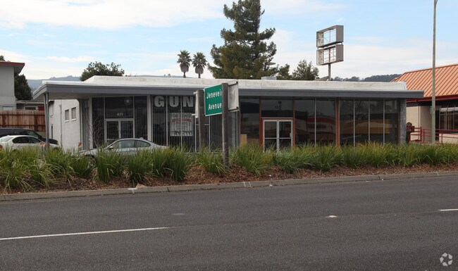
Property Detail
471 El Camino Real
020-276-300
BEING PTN LOTS 1 13 & 14 BLK 1 HUNTINGTON PK FIRST ADD RSM 5/40 & LOT 22 & PTN LOT 21 UNCLE TOMS PK NO 2 RSM 22/41
Storebuilding
San Mateo
CN0000
California
B and X Area of moderate flood hazard, usually the area between the limits of the 100-year and 500-year floods.
1,22
2024
0.15 AC
2025
San Bruno/Millbrae
603900
San Francisco
3,883 SF
San Francisco-San Mateo-Redwood City, CA
NEARBY LISTINGS FOR SALE OR LEASE
DEMOGRAPHICS near 471 El Camino Real
1 mile
3 mile
5 mile
2025 Total Population
24,158
111,307
222,920
2030 Population
24,217
111,858
224,162
Pop Growth 2025-2030
+ 0.24%
+ 0.50%
+ 0.56%
Average Age
42
43
43
2025 Total Households
8,601
38,449
78,621
HH Growth 2025-2030
+ 0.35%
+ 0.41%
+ 0.55%
Median Household Inc
$133,529
$136,000
$143,957
Avg Household Size
2.70
2.80
2.70
2025 Avg HH Vehicles
2.00
2.00
2.00
Median Home Value
$1,016,891
$1,092,562
$1,087,817
Median Year Built
1957
1961
1965
Nearby Places
Map Layers
Map Styles
 Street
 Aerial
Transit
 Traffic
 Biking
Places
Listings with unknown addresses are not visible on the map
- Restaurants
- Banks
- Shops
- Fitness
- Groceries
PUBLIC TRANSPORTATION
COMMUTER RAIL
Drive
Walk
Distance
2 min
12 min
0.6 mi
Drive
Walk
Distance
6 min
2.6 mi
AIRPORT
San Francisco International
Drive
Walk
Distance
San Francisco International
8 min
3.5 mi
Metro Oakland International
Drive
Walk
Distance
Metro Oakland International
43 min
32.4 mi
Norman Y Mineta San Jose International
Drive
Walk
Distance
Norman Y Mineta San Jose International
43 min
33.8 mi
Freight Ports
Port of San Francisco
Drive
Walk
Distance
Port of San Francisco
23 min
15.0 mi
Nearby Properties
Address
Land Use
TOTAL SIZE
Lot Size
Zoning
Address
Land Use
TOTAL SIZE
Lot Size
Zoning
780,375 SF
23.23 AC
Address
Land Use
TOTAL SIZE
Lot Size
Zoning
2,008 SF
16.83 AC
Address
Land Use
TOTAL SIZE
Lot Size
Zoning
Address
Land Use
TOTAL SIZE
Lot Size
Zoning
6.67 AC
PD0000
Address
Land Use
TOTAL SIZE
Lot Size
Zoning
Address
Land Use
TOTAL SIZE
Lot Size
Zoning
24,070 SF
6.44 AC
M2000H
Address
Land Use
TOTAL SIZE
Lot Size
Zoning
529,342 SF
5.28 AC
Address
Land Use
TOTAL SIZE
Lot Size
Zoning
161,850 SF
7.48 AC
Address
Land Use
TOTAL SIZE
Lot Size
Zoning
4,047 SF
4.25 AC
Address
Land Use
TOTAL SIZE
Lot Size
Zoning
293,445 SF
6.70 AC
MH00M2
Address
Land Use
TOTAL SIZE
Lot Size
Zoning
10,000 SF
0.48 AC
ML00M1
Address
Land Use
TOTAL SIZE
Lot Size
Zoning
528,605 SF
17.06 AC
M2000H
Address
Land Use
TOTAL SIZE
Lot Size
Zoning
152,145 SF
6.10 AC
MH00M2
Address
Land Use
TOTAL SIZE
Lot Size
Zoning
176,096 SF
2.74 AC
Address
Land Use
TOTAL SIZE
Lot Size
Zoning
112,912 SF
5.96 AC
MH00M2
Address
Land Use
TOTAL SIZE
Lot Size
Zoning
254,775 SF
17.01 AC
Address
Land Use
TOTAL SIZE
Lot Size
Zoning
198,375 SF
5.52 AC
PD0000
Address
Land Use
TOTAL SIZE
Lot Size
Zoning
5.02 AC
Address
Land Use
TOTAL SIZE
Lot Size
Zoning
126,971 SF
3.04 AC
Address
Land Use
TOTAL SIZE
Lot Size
Zoning
19,657 SF
0.69 AC
Address
Land Use
TOTAL SIZE
Lot Size
Zoning
Address
Land Use
TOTAL SIZE
Lot Size
Zoning
107,773 SF
6.73 AC
M20000
Address
Land Use
TOTAL SIZE
Lot Size
Zoning
2.83 AC
Address
Land Use
TOTAL SIZE
Lot Size
Zoning
55,000 SF
1.64 AC
ML00M1
Address
Land Use
TOTAL SIZE
Lot Size
Zoning
403,363 SF
11.26 AC
PD0000
Address
Land Use
TOTAL SIZE
Lot Size
Zoning
85,500 SF
2.20 AC
Address
Land Use
TOTAL SIZE
Lot Size
Zoning
210,895 SF
2.89 AC
Address
Land Use
TOTAL SIZE
Lot Size
Zoning
2.57 AC
Address
Land Use
TOTAL SIZE
Lot Size
Zoning
321,315 SF
6.18 AC
Address
Land Use
TOTAL SIZE
Lot Size
Zoning
2,023 SF
2.98 AC
MH00M2
The World's #1 Commercial Real Estate Marketplace
Connect with us
© 2026 CoStar Group
The information above has been obtained from sources believed reliable. While we do not doubt its accuracy we have not verified it and make no guarantee, warranty or representation about it. It is your responsibility to independently confirm its accuracy and completeness. Any projections, opinions, assumptions, or estimates used are for example only and do not represent the current or future performance of the property. The value of this transaction to you depends on tax and other factors which should be evaluated by your tax, financial, and legal advisors. You and your advisors should conduct a careful, independent investigation of the property to determine to your satisfaction the suitability of the property for your needs.