Property Record
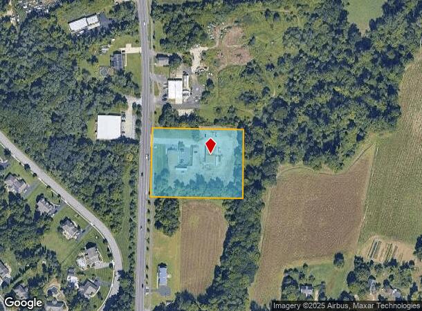
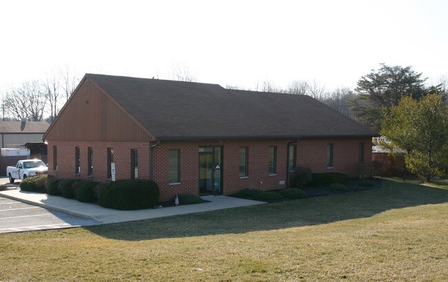
471 Main St, Mantua, NJ 08051


NEARBY LISTINGS FOR SALE OR LEASE
Property Detail
471 Main St
Philadelphia-Camden-Wilmington, PA-NJ-DE-MD
ALSO LOT 12 8
10-00160-0000-00011
Gloucester
Warehouse
New Jersey
X
11
34015C0093E
2.73 AC
2024
Gloucester County
2025
Philadelphia
500704
DEMOGRAPHICS near 471 Main St
1 Mile
3 Mile
5 Mile
2024 Total Population
5,377
39,289
118,871
2029 Population
5,549
40,574
122,707
Pop Growth 2024-2029
+ 3.20%
+ 3.27%
+ 3.23%
Average Age
41
41
41
2024 Total Households
2,072
14,957
45,155
HH Growth 2024-2029
+ 3.28%
+ 3.34%
+ 3.28%
Median Household Inc
$115,224
$104,261
$99,556
Avg Household Size
2.60
2.60
2.60
2024 Avg HH Vehicles
2.00
2.00
2.00
Median Home Value
$276,770
$280,740
$280,688
Median Year Built
1987
1980
1977
Nearby Places
Map Layers
Map Styles
 Street
 Aerial
- Restaurants
- Banks
- Shops
- Fitness
- Groceries
PUBLIC TRANSPORTATION
AIRPORT
Philadelphia International
DRIVE
WALK
Distance
Philadelphia International
37 min
19.9 mi
Trenton Mercer
DRIVE
WALK
Distance
Trenton Mercer
72 min
45.9 mi
Atlantic City International
DRIVE
WALK
Distance
Atlantic City International
82 min
47.3 mi
Freight Ports
Broadway Terminal - Pier 5
DRIVE
WALK
Distance
Broadway Terminal - Pier 5
20 min
9.9 mi
Nearby Properties
Address
Land Use
TOTAL SIZE
Lot Size
Zoning
Address
Land Use
TOTAL SIZE
Lot Size
Zoning
228.36 AC
INS
Address
Land Use
TOTAL SIZE
Lot Size
Zoning
32.64 AC
INS
Address
Land Use
TOTAL SIZE
Lot Size
Zoning
80.26 AC
INS
Address
Land Use
TOTAL SIZE
Lot Size
Zoning
35.50 AC
R4
Address
Land Use
TOTAL SIZE
Lot Size
Zoning
63.46 AC
INS
Address
Land Use
TOTAL SIZE
Lot Size
Zoning
38.17 AC
R4
Address
Land Use
TOTAL SIZE
Lot Size
Zoning
21.16 AC
INS
Address
Land Use
TOTAL SIZE
Lot Size
Zoning
15.98 AC
PC
Address
Land Use
TOTAL SIZE
Lot Size
Zoning
111.40 AC
RRC
Address
Land Use
TOTAL SIZE
Lot Size
Zoning
1,316 SF
16.04 AC
PC
Address
Land Use
TOTAL SIZE
Lot Size
Zoning
7.01 AC
R11
Address
Land Use
TOTAL SIZE
Lot Size
Zoning
8.89 AC
Address
Land Use
TOTAL SIZE
Lot Size
Zoning
14.11 AC
SC
Address
Land Use
TOTAL SIZE
Lot Size
Zoning
14.14 AC
R11
Address
Land Use
TOTAL SIZE
Lot Size
Zoning
12.73 AC
Address
Land Use
TOTAL SIZE
Lot Size
Zoning
28.70 AC
M1
Address
Land Use
TOTAL SIZE
Lot Size
Zoning
2.62 AC
Address
Land Use
TOTAL SIZE
Lot Size
Zoning
27.40 AC
LI
Address
Land Use
TOTAL SIZE
Lot Size
Zoning
13,221 SF
9.92 AC
HC
Address
Land Use
TOTAL SIZE
Lot Size
Zoning
Address
Land Use
TOTAL SIZE
Lot Size
Zoning
11.51 AC
Address
Land Use
TOTAL SIZE
Lot Size
Zoning
14.43 AC
CC
Address
Land Use
TOTAL SIZE
Lot Size
Zoning
12.30 AC
R1
Address
Land Use
TOTAL SIZE
Lot Size
Zoning
25.95 AC
M1
Address
Land Use
TOTAL SIZE
Lot Size
Zoning
Address
Land Use
TOTAL SIZE
Lot Size
Zoning
6.27 AC
INS
Address
Land Use
TOTAL SIZE
Lot Size
Zoning
7.25 AC
Address
Land Use
TOTAL SIZE
Lot Size
Zoning
10.15 AC
LI
Address
Land Use
TOTAL SIZE
Lot Size
Zoning
16.14 AC
PC
Address
Land Use
TOTAL SIZE
Lot Size
Zoning
25.47 AC
I
The World's #1 Commercial Real Estate Marketplace
Connect with us
© 2025 CoStar Group
The information above has been obtained from sources believed reliable. While we do not doubt its accuracy we have not verified it and make no guarantee, warranty or representation about it. It is your responsibility to independently confirm its accuracy and completeness. Any projections, opinions, assumptions, or estimates used are for example only and do not represent the current or future performance of the property. The value of this transaction to you depends on tax and other factors which should be evaluated by your tax, financial, and legal advisors. You and your advisors should conduct a careful, independent investigation of the property to determine to your satisfaction the suitability of the property for your needs.