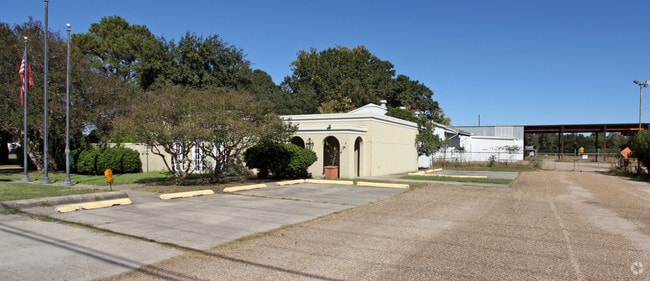
Property Record
4710 Cameron St, Lafayette, LA 70506

Property Detail
4710 Cameron St
6014184
SEC 29 T9S R4E (8 AC)
Officebuilding
LAFAYETTE
AE The base floodplain where base flood elevations are provided. AE Zones are now used on new format FIRMs instead of A1-A30 Zones.
Louisiana
2025
8 AC
2025
Outlying Lafayette Parish
001908
Lafayette
2,820 SF
Lafayette, LA
NEARBY LISTINGS FOR SALE OR LEASE
-
-
No Photo
-
-
View all Lafayette listings for sale on LoopNet.com
DEMOGRAPHICS near 4710 Cameron St
1 mile
3 mile
5 mile
2025 Total Population
2,744
46,841
119,811
2030 Population
2,871
48,866
125,315
Pop Growth 2025-2030
+ 4.63%
+ 4.32%
+ 4.59%
Average Age
40
39
39
2025 Total Households
1,183
20,243
50,530
HH Growth 2025-2030
+ 4.73%
+ 4.25%
+ 4.63%
Median Household Inc
$40,676
$52,160
$54,228
Avg Household Size
2.30
2.20
2.20
2025 Avg HH Vehicles
1.00
2.00
2.00
Median Home Value
$160,377
$210,944
$224,463
Median Year Built
1986
1981
1980
Nearby Places
Map Layers
Map Styles
 Street
 Aerial
Layers
 Traffic
 Biking
Places
Listings with unknown addresses are not visible on the map
- Restaurants
- Banks
- Shops
- Fitness
- Groceries
PUBLIC TRANSPORTATION
COMMUTER RAIL
Lafayette Amtrak Station (Sunset Limited - Amtrak)
Drive
Walk
Distance
Lafayette Amtrak Station (Sunset Limited - Amtrak)
7 min
4.2 mi
AIRPORT
Lafayette Regional/Paul Fournet Field
Drive
Walk
Distance
Lafayette Regional/Paul Fournet Field
12 min
6.6 mi
Freight Ports
Port of Iberia
Drive
Walk
Distance
Port of Iberia
37 min
27.5 mi
Nearby Properties
Address
Land Use
TOTAL SIZE
Lot Size
Zoning
Address
Land Use
TOTAL SIZE
Lot Size
Zoning
272,945 SF
21.64 AC
Address
Land Use
TOTAL SIZE
Lot Size
Zoning
140,051 SF
26.21 AC
Address
Land Use
TOTAL SIZE
Lot Size
Zoning
141,295 SF
28.09 AC
Address
Land Use
TOTAL SIZE
Lot Size
Zoning
443,758 SF
19.73 AC
Address
Land Use
TOTAL SIZE
Lot Size
Zoning
10.80 AC
Address
Land Use
TOTAL SIZE
Lot Size
Zoning
249,875 SF
29.76 AC
Address
Land Use
TOTAL SIZE
Lot Size
Zoning
96.54 AC
Address
Land Use
TOTAL SIZE
Lot Size
Zoning
12.42 AC
Address
Land Use
TOTAL SIZE
Lot Size
Zoning
32.14 AC
Address
Land Use
TOTAL SIZE
Lot Size
Zoning
29.99 AC
Address
Land Use
TOTAL SIZE
Lot Size
Zoning
15,386 SF
13.17 AC
Address
Land Use
TOTAL SIZE
Lot Size
Zoning
47,249 SF
22.17 AC
Address
Land Use
TOTAL SIZE
Lot Size
Zoning
250,211 SF
7.77 AC
Address
Land Use
TOTAL SIZE
Lot Size
Zoning
67,672 SF
10.18 AC
Address
Land Use
TOTAL SIZE
Lot Size
Zoning
66,678 SF
0.01 AC
Address
Land Use
TOTAL SIZE
Lot Size
Zoning
139,738 SF
11.05 AC
Address
Land Use
TOTAL SIZE
Lot Size
Zoning
18,182 SF
8 AC
Address
Land Use
TOTAL SIZE
Lot Size
Zoning
Address
Land Use
TOTAL SIZE
Lot Size
Zoning
12,430 SF
10.18 AC
Address
Land Use
TOTAL SIZE
Lot Size
Zoning
194,632 SF
10.95 AC
Address
Land Use
TOTAL SIZE
Lot Size
Zoning
Address
Land Use
TOTAL SIZE
Lot Size
Zoning
41,595 SF
Address
Land Use
TOTAL SIZE
Lot Size
Zoning
97,292 SF
6.66 AC
Address
Land Use
TOTAL SIZE
Lot Size
Zoning
20,398 SF
3.57 AC
Address
Land Use
TOTAL SIZE
Lot Size
Zoning
98,591 SF
25.08 AC
Address
Land Use
TOTAL SIZE
Lot Size
Zoning
34,218 SF
11.94 AC
Address
Land Use
TOTAL SIZE
Lot Size
Zoning
55,902 SF
12 AC
Address
Land Use
TOTAL SIZE
Lot Size
Zoning
8.75 AC
Address
Land Use
TOTAL SIZE
Lot Size
Zoning
13,104 SF
8.79 AC
Address
Land Use
TOTAL SIZE
Lot Size
Zoning
35,595 SF
8 AC
The World's #1 Commercial Real Estate Marketplace
Connect with us
© 2026 CoStar Group
The information above has been obtained from sources believed reliable. While we do not doubt its accuracy we have not verified it and make no guarantee, warranty or representation about it. It is your responsibility to independently confirm its accuracy and completeness. Any projections, opinions, assumptions, or estimates used are for example only and do not represent the current or future performance of the property. The value of this transaction to you depends on tax and other factors which should be evaluated by your tax, financial, and legal advisors. You and your advisors should conduct a careful, independent investigation of the property to determine to your satisfaction the suitability of the property for your needs.