Property Record
4710 Canyon Dr, Amarillo, TX 79109
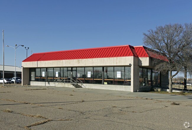

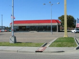

Property Detail
4710 Canyon Dr
Amarillo, TX
Western-Air Addn # 19
R-086-3420-3530-0
WESTERN-AIR ADDN # 19, BLK 0006, ALL OF 5 & S 28FT OF 3 IN # 17, 2.3200 ACRES
Vehiclerentalsvehiclesales
Randall
X
Texas
48375C0520C
5
2024
2.32 AC
2025
Amarillo
021102
Other Market Areas
13,700 SF
NEARBY LISTINGS FOR SALE OR LEASE
DEMOGRAPHICS near 4710 Canyon Dr
1 mile
3 mile
5 mile
2024 Total Population
13,754
93,165
154,410
2029 Population
15,198
100,306
163,317
Pop Growth 2024-2029
+ 10.50%
+ 7.66%
+ 5.77%
Average Age
39
39
38
2024 Total Households
6,459
38,966
63,563
HH Growth 2024-2029
+ 11.07%
+ 7.77%
+ 5.75%
Median Household Inc
$48,184
$64,045
$59,600
Avg Household Size
2.10
2.30
2.30
2024 Avg HH Vehicles
2.00
2.00
2.00
Median Home Value
$154,226
$177,295
$173,843
Median Year Built
1973
1974
1975
Nearby Places
Map Layers
Map Styles
 Street
 Aerial
Transit
 Traffic
 Biking
Places
Listings with unknown addresses are not visible on the map
- Restaurants
- Banks
- Shops
- Fitness
- Groceries
PUBLIC TRANSPORTATION
AIRPORT
Rick Husband Amarillo International
Drive
Walk
Distance
Rick Husband Amarillo International
21 min
13.8 mi
Freight Ports
Tulsa Port Of Catoosa
Drive
Walk
Distance
Tulsa Port Of Catoosa
403 min
381.8 mi
SALE & LEASE HISTORY
LISTING DATE
SALE/LEASE

May 09, 2019
For Sale
Nearby Properties
Address
Land Use
TOTAL SIZE
Lot Size
Zoning
Address
Land Use
TOTAL SIZE
Lot Size
Zoning
362,796 SF
49.98 AC
A
Address
Land Use
TOTAL SIZE
Lot Size
Zoning
228,223 SF
20.83 AC
Address
Land Use
TOTAL SIZE
Lot Size
Zoning
431,320 SF
14.82 AC
1F2 S
Address
Land Use
TOTAL SIZE
Lot Size
Zoning
342,930 SF
34.57 AC
PD
Address
Land Use
TOTAL SIZE
Lot Size
Zoning
112,261 SF
21.82 AC
Address
Land Use
TOTAL SIZE
Lot Size
Zoning
168,978 SF
4.23 AC
1F2 S
Address
Land Use
TOTAL SIZE
Lot Size
Zoning
207,120 SF
16.54 AC
GR
Address
Land Use
TOTAL SIZE
Lot Size
Zoning
345,555 SF
23.69 AC
PD
Address
Land Use
TOTAL SIZE
Lot Size
Zoning
373,014 SF
14.20 AC
Address
Land Use
TOTAL SIZE
Lot Size
Zoning
260,680 SF
10.16 AC
Address
Land Use
TOTAL SIZE
Lot Size
Zoning
145,652 SF
20.53 AC
Address
Land Use
TOTAL SIZE
Lot Size
Zoning
168,130 SF
16.32 AC
Address
Land Use
TOTAL SIZE
Lot Size
Zoning
182,242 SF
20.70 AC
Address
Land Use
TOTAL SIZE
Lot Size
Zoning
210,217 SF
10.49 AC
M11
Address
Land Use
TOTAL SIZE
Lot Size
Zoning
74,960 SF
7 AC
R2
Address
Land Use
TOTAL SIZE
Lot Size
Zoning
204,468 SF
17.56 AC
Address
Land Use
TOTAL SIZE
Lot Size
Zoning
99,739 SF
3.88 AC
R2
Address
Land Use
TOTAL SIZE
Lot Size
Zoning
167,257 SF
12.66 AC
Address
Land Use
TOTAL SIZE
Lot Size
Zoning
161,221 SF
11.78 AC
MF1
Address
Land Use
TOTAL SIZE
Lot Size
Zoning
112,005 SF
7.70 AC
GR
Address
Land Use
TOTAL SIZE
Lot Size
Zoning
227,707 SF
10.78 AC
GR
Address
Land Use
TOTAL SIZE
Lot Size
Zoning
200,117 SF
7.96 AC
GR
Address
Land Use
TOTAL SIZE
Lot Size
Zoning
183,758 SF
16.74 AC
R2
Address
Land Use
TOTAL SIZE
Lot Size
Zoning
132,914 SF
10.20 AC
PD
Address
Land Use
TOTAL SIZE
Lot Size
Zoning
185,895 SF
9.59 AC
Address
Land Use
TOTAL SIZE
Lot Size
Zoning
172,531 SF
10.37 AC
LC
Address
Land Use
TOTAL SIZE
Lot Size
Zoning
297,246 SF
13.91 AC
MF1
Address
Land Use
TOTAL SIZE
Lot Size
Zoning
187,253 SF
9.69 AC
PD
Address
Land Use
TOTAL SIZE
Lot Size
Zoning
120,684 SF
18.94 AC
R2
Address
Land Use
TOTAL SIZE
Lot Size
Zoning
68,214 SF
9.06 AC
The World's #1 Commercial Real Estate Marketplace
Connect with us
© 2026 CoStar Group
The information above has been obtained from sources believed reliable. While we do not doubt its accuracy we have not verified it and make no guarantee, warranty or representation about it. It is your responsibility to independently confirm its accuracy and completeness. Any projections, opinions, assumptions, or estimates used are for example only and do not represent the current or future performance of the property. The value of this transaction to you depends on tax and other factors which should be evaluated by your tax, financial, and legal advisors. You and your advisors should conduct a careful, independent investigation of the property to determine to your satisfaction the suitability of the property for your needs.