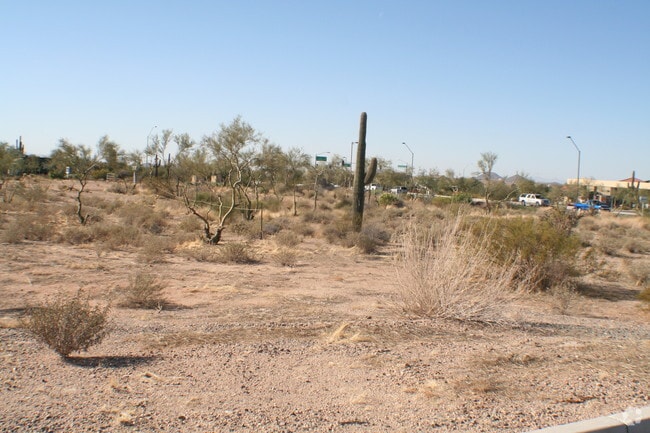
Property Record
4710 E Lone Mountain Rd, Cave Creek, AZ 85331

Property Detail
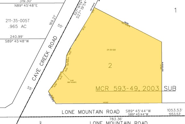
4710 E Lone Mountain Rd
211-35-020
LONE MOUNTAIN LANDING MCR 593-49
Daycare
Maricopa
C-2
Arizona
C and X Area of minimal flood hazard, usually depicted on FIRMs as above the 500-year flood level.
2
2025
3.14 AC
2025
N Phoenix/Cave Creek
613000
Phoenix
27,015 SF
Phoenix-Mesa-Chandler, AZ
NEARBY LISTINGS FOR SALE OR LEASE
DEMOGRAPHICS near 4710 E Lone Mountain Rd
1 mile
3 mile
5 mile
2025 Total Population
5,162
27,466
46,716
2030 Population
5,179
28,014
48,227
Pop Growth 2025-2030
+ 0.33%
+ 2.00%
+ 3.23%
Average Age
45
46
49
2025 Total Households
2,018
10,760
18,964
HH Growth 2025-2030
+ 0.10%
+ 2.05%
+ 3.48%
Median Household Inc
$129,798
$137,409
$140,438
Avg Household Size
2.50
2.50
2.40
2025 Avg HH Vehicles
2.00
2.00
2.00
Median Home Value
$709,974
$766,921
$839,275
Median Year Built
1996
1997
1997
Nearby Places
Map Layers
Map Styles
 Street
 Aerial
Layers
 Traffic
 Biking
Places
Listings with unknown addresses are not visible on the map
- Restaurants
- Banks
- Shops
- Fitness
- Groceries
PUBLIC TRANSPORTATION
AIRPORT
Phoenix Sky Harbor International
Drive
Walk
Distance
Phoenix Sky Harbor International
43 min
28.5 mi
Nearby Properties
Address
Land Use
TOTAL SIZE
Lot Size
Zoning
Address
Land Use
TOTAL SIZE
Lot Size
Zoning
557,887 SF
163.54 AC
R-43
Address
Land Use
TOTAL SIZE
Lot Size
Zoning
108,124 SF
26.19 AC
R-35
Address
Land Use
TOTAL SIZE
Lot Size
Zoning
123,518 SF
14.92 AC
C-C
Address
Land Use
TOTAL SIZE
Lot Size
Zoning
10 SF
13.75 AC
R-35
Address
Land Use
TOTAL SIZE
Lot Size
Zoning
126,785 SF
17.94 AC
C-G
Address
Land Use
TOTAL SIZE
Lot Size
Zoning
79,429 SF
17.76 AC
R-35
Address
Land Use
TOTAL SIZE
Lot Size
Zoning
55,995 SF
17.95 AC
R-35
Address
Land Use
TOTAL SIZE
Lot Size
Zoning
30,172 SF
14.13 AC
S1
Address
Land Use
TOTAL SIZE
Lot Size
Zoning
70.35 AC
R-35
Address
Land Use
TOTAL SIZE
Lot Size
Zoning
34,576 SF
23 AC
R-43
Address
Land Use
TOTAL SIZE
Lot Size
Zoning
115,432 SF
12.98 AC
C-C
Address
Land Use
TOTAL SIZE
Lot Size
Zoning
13,960 SF
33.20 AC
R-35
Address
Land Use
TOTAL SIZE
Lot Size
Zoning
65,728 SF
12.07 AC
C-C
Address
Land Use
TOTAL SIZE
Lot Size
Zoning
74,132 SF
7.93 AC
PAD
Address
Land Use
TOTAL SIZE
Lot Size
Zoning
6,526 SF
76.43 AC
DR89
Address
Land Use
TOTAL SIZE
Lot Size
Zoning
47,830 SF
5.22 AC
R-43
Address
Land Use
TOTAL SIZE
Lot Size
Zoning
43,674 SF
9.26 AC
C-C
Address
Land Use
TOTAL SIZE
Lot Size
Zoning
135,578 SF
2.85 AC
C-C
Address
Land Use
TOTAL SIZE
Lot Size
Zoning
600 SF
38.67 AC
R-43
Address
Land Use
TOTAL SIZE
Lot Size
Zoning
116,269 SF
5.01 AC
C-N
Address
Land Use
TOTAL SIZE
Lot Size
Zoning
140,290 SF
5.13 AC
CP/GCP
Address
Land Use
TOTAL SIZE
Lot Size
Zoning
45,425 SF
22.94 AC
R-43AG
Address
Land Use
TOTAL SIZE
Lot Size
Zoning
34,693 SF
5.73 AC
R-35
Address
Land Use
TOTAL SIZE
Lot Size
Zoning
52,022 SF
10.01 AC
R-43
Address
Land Use
TOTAL SIZE
Lot Size
Zoning
60,652 SF
6.82 AC
C-C
Address
Land Use
TOTAL SIZE
Lot Size
Zoning
31,823 SF
1.80 AC
R-43
Address
Land Use
TOTAL SIZE
Lot Size
Zoning
21,828 SF
58.46 AC
R-43
Address
Land Use
TOTAL SIZE
Lot Size
Zoning
55,478 SF
5.24 AC
C-C
Address
Land Use
TOTAL SIZE
Lot Size
Zoning
1,010.34 AC
R-35
Address
Land Use
TOTAL SIZE
Lot Size
Zoning
102,591 SF
3.81 AC
C-C
The World's #1 Commercial Real Estate Marketplace
Connect with us
© 2026 CoStar Group
The information above has been obtained from sources believed reliable. While we do not doubt its accuracy we have not verified it and make no guarantee, warranty or representation about it. It is your responsibility to independently confirm its accuracy and completeness. Any projections, opinions, assumptions, or estimates used are for example only and do not represent the current or future performance of the property. The value of this transaction to you depends on tax and other factors which should be evaluated by your tax, financial, and legal advisors. You and your advisors should conduct a careful, independent investigation of the property to determine to your satisfaction the suitability of the property for your needs.