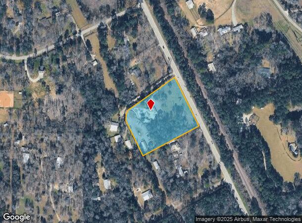
Property Record
4711 Fm 149 Rd, Magnolia, TX 77354
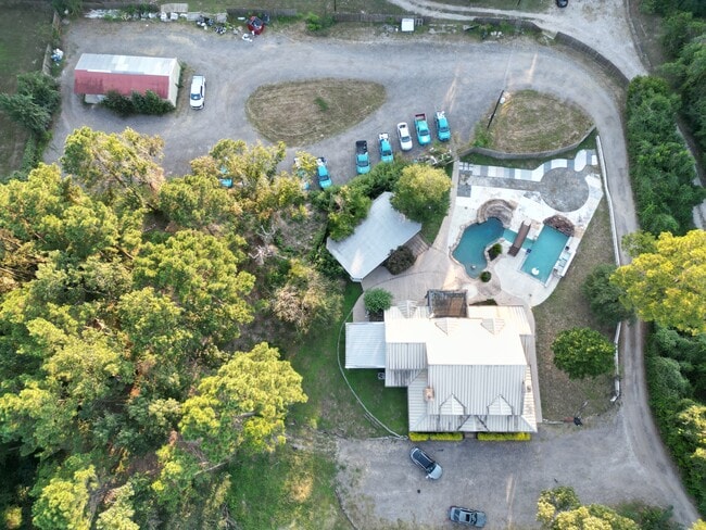
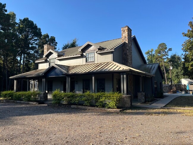
This Property Is For Sale
Current Lease Availabilities
NEARBY LISTINGS FOR SALE OR LEASE
Property Detail
4711 Fm 149 Rd
Houston-The Woodlands-Sugar Land, TX
George Robin
0469-02-00660
Montgomery
Sfr
Texas
X
3.33 AC
48339C0350G
Outlying Montgomery Cnty
4,715 SF
Houston
DEMOGRAPHICS near 4711 Fm 149 Rd
1 Mile
3 Mile
5 Mile
2024 Total Population
1,105
8,383
27,811
2029 Population
1,325
10,034
33,018
Pop Growth 2024-2029
+ 19.91%
+ 19.69%
+ 18.72%
Average Age
40
40
39
2024 Total Households
375
2,831
9,288
HH Growth 2024-2029
+ 20.53%
+ 20.20%
+ 19.23%
Median Household Inc
$126,330
$110,842
$94,552
Avg Household Size
3.00
3.00
3.00
2024 Avg HH Vehicles
2.00
2.00
2.00
Median Home Value
$507,396
$511,515
$459,451
Median Year Built
2010
2010
2008
Nearby Places
- Restaurants
- Banks
- Shops
- Fitness
- Groceries
PUBLIC TRANSPORTATION
AIRPORT
George Bush Intcntl/Houston
DRIVE
WALK
Distance
George Bush Intcntl/Houston
51 min
39.4 mi
Freight Ports
Port of Houston
DRIVE
WALK
Distance
Port of Houston
71 min
50.1 mi
Nearby Properties
Address
Land Use
TOTAL SIZE
Lot Size
Zoning
Address
Land Use
TOTAL SIZE
Lot Size
Zoning
413,128 SF
11.80 AC
Address
Land Use
TOTAL SIZE
Lot Size
Zoning
373,975 SF
107.48 AC
2
Address
Land Use
TOTAL SIZE
Lot Size
Zoning
150,000 SF
15 AC
Address
Land Use
TOTAL SIZE
Lot Size
Zoning
102,444 SF
15.14 AC
Address
Land Use
TOTAL SIZE
Lot Size
Zoning
167,908 SF
32.46 AC
Address
Land Use
TOTAL SIZE
Lot Size
Zoning
14,830 SF
2.38 AC
Address
Land Use
TOTAL SIZE
Lot Size
Zoning
20,826 SF
3.45 AC
Address
Land Use
TOTAL SIZE
Lot Size
Zoning
10.86 AC
Address
Land Use
TOTAL SIZE
Lot Size
Zoning
18.18 AC
2
Address
Land Use
TOTAL SIZE
Lot Size
Zoning
5,556 SF
1.35 AC
Address
Land Use
TOTAL SIZE
Lot Size
Zoning
9,868 SF
7.55 AC
Address
Land Use
TOTAL SIZE
Lot Size
Zoning
9,683 SF
1.91 AC
Address
Land Use
TOTAL SIZE
Lot Size
Zoning
7,920 SF
1.95 AC
2
Address
Land Use
TOTAL SIZE
Lot Size
Zoning
8,181 SF
4.25 AC
Address
Land Use
TOTAL SIZE
Lot Size
Zoning
8,065 SF
1.54 AC
Address
Land Use
TOTAL SIZE
Lot Size
Zoning
3,377 SF
1.41 AC
Address
Land Use
TOTAL SIZE
Lot Size
Zoning
5,584 SF
1.18 AC
Address
Land Use
TOTAL SIZE
Lot Size
Zoning
6,800 SF
12.20 AC
2
Address
Land Use
TOTAL SIZE
Lot Size
Zoning
6,300 SF
0.87 AC
Address
Land Use
TOTAL SIZE
Lot Size
Zoning
19,566 SF
8.74 AC
2
Address
Land Use
TOTAL SIZE
Lot Size
Zoning
6,034 SF
4.02 AC
Address
Land Use
TOTAL SIZE
Lot Size
Zoning
7,490 SF
3.10 AC
Address
Land Use
TOTAL SIZE
Lot Size
Zoning
5.38 AC
2
The World's #1 Commercial Real Estate Marketplace
Connect with us
© 2025 CoStar Group
The information above has been obtained from sources believed reliable. While we do not doubt its accuracy we have not verified it and make no guarantee, warranty or representation about it. It is your responsibility to independently confirm its accuracy and completeness. Any projections, opinions, assumptions, or estimates used are for example only and do not represent the current or future performance of the property. The value of this transaction to you depends on tax and other factors which should be evaluated by your tax, financial, and legal advisors. You and your advisors should conduct a careful, independent investigation of the property to determine to your satisfaction the suitability of the property for your needs.