Property Record
4711 Kenard Ave, Cincinnati, OH 45232

Property Detail
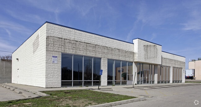
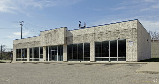
4711 Kenard Ave
Cincinnati, OH-KY-IN
KENARD AVE PT LOT 9 42,044 SQ FT MITCHELL INDUSTRIAL SUB PHASE III
219-0060-0020
Hamilton
Storebuilding
Ohio
CCA
9
2025
0.97 AC
2025
Reading/Roselawn
007300
Cincinnati/Dayton
NEARBY LISTINGS FOR SALE OR LEASE
DEMOGRAPHICS near 4711 Kenard Ave
1 mile
3 mile
5 mile
2025 Total Population
6,190
120,263
343,605
2030 Population
6,223
122,935
350,087
Pop Growth 2025-2030
+ 0.53%
+ 2.22%
+ 1.89%
Average Age
39
35
37
2025 Total Households
2,712
49,743
150,691
HH Growth 2025-2030
+ 0.52%
+ 2.30%
+ 1.97%
Median Household Inc
$70,331
$43,102
$55,207
Avg Household Size
2.20
2.10
2.10
2025 Avg HH Vehicles
2.00
1.00
1.00
Median Home Value
$212,874
$227,774
$225,007
Median Year Built
1948
1949
1952
Nearby Places
Map Layers
Map Styles
 Street
 Aerial
Layers
 Traffic
 Biking
Places
Listings with unknown addresses are not visible on the map
- Restaurants
- Banks
- Shops
- Fitness
- Groceries
PUBLIC TRANSPORTATION
COMMUTER RAIL
Drive
Walk
Distance
11 min
5.8 mi
AIRPORT
Cincinnati/Northern Kentucky International
Drive
Walk
Distance
Cincinnati/Northern Kentucky International
31 min
18.0 mi
Nearby Properties
Address
Land Use
TOTAL SIZE
Lot Size
Zoning
Address
Land Use
TOTAL SIZE
Lot Size
Zoning
77.73 AC
IR
Address
Land Use
TOTAL SIZE
Lot Size
Zoning
6.35 AC
IR
Address
Land Use
TOTAL SIZE
Lot Size
Zoning
62.10 AC
Address
Land Use
TOTAL SIZE
Lot Size
Zoning
22.45 AC
Address
Land Use
TOTAL SIZE
Lot Size
Zoning
3.09 AC
Address
Land Use
TOTAL SIZE
Lot Size
Zoning
2.80 AC
IR
Address
Land Use
TOTAL SIZE
Lot Size
Zoning
3.40 AC
IR
Address
Land Use
TOTAL SIZE
Lot Size
Zoning
Address
Land Use
TOTAL SIZE
Lot Size
Zoning
Address
Land Use
TOTAL SIZE
Lot Size
Zoning
7.14 AC
Address
Land Use
TOTAL SIZE
Lot Size
Zoning
26.16 AC
Address
Land Use
TOTAL SIZE
Lot Size
Zoning
13.32 AC
Address
Land Use
TOTAL SIZE
Lot Size
Zoning
16.67 AC
IR
Address
Land Use
TOTAL SIZE
Lot Size
Zoning
3,184 SF
2.34 AC
IR
Address
Land Use
TOTAL SIZE
Lot Size
Zoning
Address
Land Use
TOTAL SIZE
Lot Size
Zoning
2.97 AC
IR
Address
Land Use
TOTAL SIZE
Lot Size
Zoning
112.35 AC
RM20
Address
Land Use
TOTAL SIZE
Lot Size
Zoning
29.60 AC
IR
Address
Land Use
TOTAL SIZE
Lot Size
Zoning
11.36 AC
IR
Address
Land Use
TOTAL SIZE
Lot Size
Zoning
0.37 AC
IR
Address
Land Use
TOTAL SIZE
Lot Size
Zoning
Address
Land Use
TOTAL SIZE
Lot Size
Zoning
Address
Land Use
TOTAL SIZE
Lot Size
Zoning
2,916 SF
27.68 AC
Address
Land Use
TOTAL SIZE
Lot Size
Zoning
Address
Land Use
TOTAL SIZE
Lot Size
Zoning
10,778 SF
0.09 AC
CCM
Address
Land Use
TOTAL SIZE
Lot Size
Zoning
3.34 AC
Address
Land Use
TOTAL SIZE
Lot Size
Zoning
1.88 AC
Address
Land Use
TOTAL SIZE
Lot Size
Zoning
1.57 AC
Address
Land Use
TOTAL SIZE
Lot Size
Zoning
6.34 AC
Address
Land Use
TOTAL SIZE
Lot Size
Zoning
1,020 SF
44.83 AC
PR
The World's #1 Commercial Real Estate Marketplace
Connect with us
© 2026 CoStar Group
The information above has been obtained from sources believed reliable. While we do not doubt its accuracy we have not verified it and make no guarantee, warranty or representation about it. It is your responsibility to independently confirm its accuracy and completeness. Any projections, opinions, assumptions, or estimates used are for example only and do not represent the current or future performance of the property. The value of this transaction to you depends on tax and other factors which should be evaluated by your tax, financial, and legal advisors. You and your advisors should conduct a careful, independent investigation of the property to determine to your satisfaction the suitability of the property for your needs.