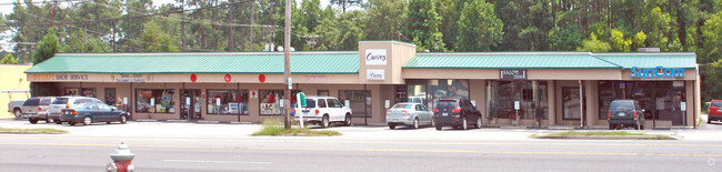
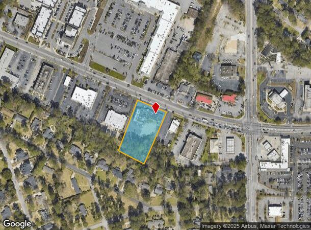
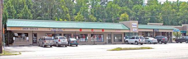
Property Record
4718 Forest Dr, Columbia, SC 29206
Current Lease Availabilities
NEARBY LISTINGS FOR SALE OR LEASE
Property Detail
4718 Forest Dr
14013-03-12
Forest Acres
Commercialnec
199.8X374.6X185.6X353.8 #SU FOREST ACRES #PR 56-3470
X
Richland
45079C0264L
South Carolina
2025
1.61 AC
2024
Forest Acres
011201
Columbia
10,057 SF
Columbia, SC
DEMOGRAPHICS near 4718 Forest Dr
1 mile
3 mile
5 mile
2024 Total Population
6,738
70,613
169,249
2029 Population
6,802
71,958
172,337
Pop Growth 2024-2029
+ 0.95%
+ 1.90%
+ 1.82%
Average Age
41
38
36
2024 Total Households
3,125
27,785
69,510
HH Growth 2024-2029
+ 1.09%
+ 2.05%
+ 1.93%
Median Household Inc
$87,762
$59,071
$46,227
Avg Household Size
2.10
2.10
2.10
2024 Avg HH Vehicles
2.00
2.00
2.00
Median Home Value
$401,536
$253,242
$203,231
Median Year Built
1964
1965
1971
Nearby Places
Map Layers
Map Styles
 Street
 Aerial
Transit
 Traffic
 Biking
Places
Listings with unknown addresses are not visible on the map
- Restaurants
- Banks
- Shops
- Fitness
- Groceries
PUBLIC TRANSPORTATION
COMMUTER RAIL
Columbia Amtrak Station (Silver Star - Amtrak)
Drive
Walk
Distance
Columbia Amtrak Station (Silver Star - Amtrak)
12 min
5.5 mi
AIRPORT
Columbia Metro
Drive
Walk
Distance
Columbia Metro
31 min
14.9 mi
Freight Ports
North Charleston Terminal
Drive
Walk
Distance
North Charleston Terminal
126 min
111.5 mi
Nearby Properties
Address
Land Use
TOTAL SIZE
Lot Size
Zoning
Address
Land Use
TOTAL SIZE
Lot Size
Zoning
501,365 SF
13.28 AC
O-I
Address
Land Use
TOTAL SIZE
Lot Size
Zoning
316,116 SF
21.73 AC
RG-2
Address
Land Use
TOTAL SIZE
Lot Size
Zoning
1,704.85 AC
RU
Address
Land Use
TOTAL SIZE
Lot Size
Zoning
13,028 SF
31.69 AC
RG-1
Address
Land Use
TOTAL SIZE
Lot Size
Zoning
313,244 SF
12.75 AC
RM-HD
Address
Land Use
TOTAL SIZE
Lot Size
Zoning
216,180 SF
15.66 AC
C-1
Address
Land Use
TOTAL SIZE
Lot Size
Zoning
231,426 SF
10 AC
C-3
Address
Land Use
TOTAL SIZE
Lot Size
Zoning
169,291 SF
18.97 AC
C-3
Address
Land Use
TOTAL SIZE
Lot Size
Zoning
9.66 AC
C-1
Address
Land Use
TOTAL SIZE
Lot Size
Zoning
129,721 SF
3.72 AC
C-3
Address
Land Use
TOTAL SIZE
Lot Size
Zoning
259,948 SF
14.40 AC
RM-HD
Address
Land Use
TOTAL SIZE
Lot Size
Zoning
202,048 SF
20.98 AC
C-3
Address
Land Use
TOTAL SIZE
Lot Size
Zoning
285,760 SF
16.12 AC
RG-2
Address
Land Use
TOTAL SIZE
Lot Size
Zoning
414,262 SF
34.45 AC
RM-HD
Address
Land Use
TOTAL SIZE
Lot Size
Zoning
90,984 SF
2.83 AC
C-1
Address
Land Use
TOTAL SIZE
Lot Size
Zoning
23,379 SF
3.76 AC
M-1
Address
Land Use
TOTAL SIZE
Lot Size
Zoning
113,510 SF
11.60 AC
GC
Address
Land Use
TOTAL SIZE
Lot Size
Zoning
55.91 AC
M-1
Address
Land Use
TOTAL SIZE
Lot Size
Zoning
20 AC
C-3
Address
Land Use
TOTAL SIZE
Lot Size
Zoning
59,316 SF
1.48 AC
C-3
Address
Land Use
TOTAL SIZE
Lot Size
Zoning
145,081 SF
22.36 AC
C-3
Address
Land Use
TOTAL SIZE
Lot Size
Zoning
97,683 SF
11.60 AC
C-3
Address
Land Use
TOTAL SIZE
Lot Size
Zoning
125,486 SF
9.97 AC
C-3
Address
Land Use
TOTAL SIZE
Lot Size
Zoning
89,639 SF
14.68 AC
C-3
Address
Land Use
TOTAL SIZE
Lot Size
Zoning
97,324 SF
9.29 AC
C-3
Address
Land Use
TOTAL SIZE
Lot Size
Zoning
3,960 SF
18.88 AC
RS-2
Address
Land Use
TOTAL SIZE
Lot Size
Zoning
138,738 SF
2.85 AC
O-I
Address
Land Use
TOTAL SIZE
Lot Size
Zoning
3.02 AC
RM-2
Address
Land Use
TOTAL SIZE
Lot Size
Zoning
65,242 SF
10.17 AC
MU-2
Address
Land Use
TOTAL SIZE
Lot Size
Zoning
51,000 SF
6.25 AC
C-3
The World's #1 Commercial Real Estate Marketplace
Connect with us
© 2026 CoStar Group
The information above has been obtained from sources believed reliable. While we do not doubt its accuracy we have not verified it and make no guarantee, warranty or representation about it. It is your responsibility to independently confirm its accuracy and completeness. Any projections, opinions, assumptions, or estimates used are for example only and do not represent the current or future performance of the property. The value of this transaction to you depends on tax and other factors which should be evaluated by your tax, financial, and legal advisors. You and your advisors should conduct a careful, independent investigation of the property to determine to your satisfaction the suitability of the property for your needs.