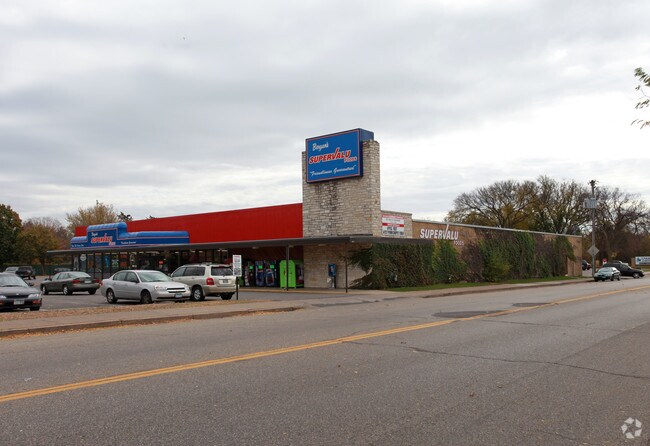
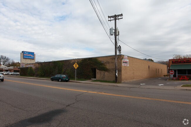
Property Record
4712 Longfellow Ave, Minneapolis, MN 55407

NEARBY LISTINGS FOR SALE OR LEASE
Property Detail
4712 Longfellow Ave
Minneapolis-St. Paul-Bloomington, MN-WI
Cedar Ave Park Mpls
13-028-24-22-0035
LOT 024 BLOCK 013 A CEDAR AVE PARK MPLS LOTS 22 THRU 25 INCL AND S 1/2 OF LOT 26 INCLUDING ADJOINING 1/2 OF VACATED ALLEY W 180X129
Apartment
Hennepin
X
Minnesota
27053C0386F
24
2024
0.78 AC
2024
Calhoun
008500
Minneapolis/St Paul
197,097 SF
DEMOGRAPHICS near 4712 Longfellow Ave
1 Mile
3 Mile
5 Mile
2024 Total Population
16,205
165,569
460,229
2029 Population
16,048
162,377
453,540
Pop Growth 2024-2029
(0.97%)
(1.93%)
(1.45%)
Average Age
40
39
38
2024 Total Households
6,910
68,813
206,101
HH Growth 2024-2029
(0.94%)
(2.07%)
(1.42%)
Median Household Inc
$105,712
$81,653
$73,287
Avg Household Size
2.30
2.30
2.10
2024 Avg HH Vehicles
2.00
2.00
1.00
Median Home Value
$340,920
$329,010
$359,291
Median Year Built
1946
1947
1956
Nearby Places
Map Layers
Map Styles
 Street
 Aerial
- Restaurants
- Banks
- Shops
- Fitness
- Groceries
PUBLIC TRANSPORTATION
COMMUTER RAIL
Target Field Station (Northstar Corridor - Northstar Commuter Rail)
DRIVE
WALK
Distance
Target Field Station (Northstar Corridor - Northstar Commuter Rail)
14 min
6.5 mi
AIRPORT
Minneapolis-St Paul International/Wold-Chamberlain
DRIVE
WALK
Distance
Minneapolis-St Paul International/Wold-Chamberlain
12 min
6.8 mi
Freight Ports
Port Milwaukee
DRIVE
WALK
Distance
Port Milwaukee
379 min
340.8 mi
Nearby Properties
Address
Land Use
TOTAL SIZE
Lot Size
Zoning
Address
Land Use
TOTAL SIZE
Lot Size
Zoning
2.65 AC
Address
Land Use
TOTAL SIZE
Lot Size
Zoning
Address
Land Use
TOTAL SIZE
Lot Size
Zoning
Address
Land Use
TOTAL SIZE
Lot Size
Zoning
179,243 SF
1.05 AC
C2
Address
Land Use
TOTAL SIZE
Lot Size
Zoning
283,912 SF
2.17 AC
R6
Address
Land Use
TOTAL SIZE
Lot Size
Zoning
164,639 SF
0.96 AC
C3S
Address
Land Use
TOTAL SIZE
Lot Size
Zoning
288,834 SF
1.72 AC
Address
Land Use
TOTAL SIZE
Lot Size
Zoning
Address
Land Use
TOTAL SIZE
Lot Size
Zoning
2.18 AC
Address
Land Use
TOTAL SIZE
Lot Size
Zoning
Address
Land Use
TOTAL SIZE
Lot Size
Zoning
254,517 SF
2.22 AC
C3A
Address
Land Use
TOTAL SIZE
Lot Size
Zoning
Address
Land Use
TOTAL SIZE
Lot Size
Zoning
Address
Land Use
TOTAL SIZE
Lot Size
Zoning
Address
Land Use
TOTAL SIZE
Lot Size
Zoning
165,618 SF
12.37 AC
Address
Land Use
TOTAL SIZE
Lot Size
Zoning
223,680 SF
2.61 AC
R5
Address
Land Use
TOTAL SIZE
Lot Size
Zoning
196,178 SF
1.26 AC
C3A
Address
Land Use
TOTAL SIZE
Lot Size
Zoning
Address
Land Use
TOTAL SIZE
Lot Size
Zoning
378,646 SF
1.47 AC
I1
Address
Land Use
TOTAL SIZE
Lot Size
Zoning
167,505 SF
1.17 AC
R5
Address
Land Use
TOTAL SIZE
Lot Size
Zoning
150,486 SF
0.54 AC
R5
Address
Land Use
TOTAL SIZE
Lot Size
Zoning
169,522 SF
1.45 AC
C3A
Address
Land Use
TOTAL SIZE
Lot Size
Zoning
421,974 SF
3.75 AC
C3A
Address
Land Use
TOTAL SIZE
Lot Size
Zoning
114,035 SF
0.78 AC
R5
Address
Land Use
TOTAL SIZE
Lot Size
Zoning
644,069 SF
15.86 AC
I1
Address
Land Use
TOTAL SIZE
Lot Size
Zoning
117,490 SF
1.25 AC
I2
Address
Land Use
TOTAL SIZE
Lot Size
Zoning
187,724 SF
2.60 AC
R5
Address
Land Use
TOTAL SIZE
Lot Size
Zoning
64,557 SF
6.34 AC
C3A
Address
Land Use
TOTAL SIZE
Lot Size
Zoning
86,188 SF
6.13 AC
R5
Address
Land Use
TOTAL SIZE
Lot Size
Zoning
The World's #1 Commercial Real Estate Marketplace
Connect with us
© 2025 CoStar Group
The information above has been obtained from sources believed reliable. While we do not doubt its accuracy we have not verified it and make no guarantee, warranty or representation about it. It is your responsibility to independently confirm its accuracy and completeness. Any projections, opinions, assumptions, or estimates used are for example only and do not represent the current or future performance of the property. The value of this transaction to you depends on tax and other factors which should be evaluated by your tax, financial, and legal advisors. You and your advisors should conduct a careful, independent investigation of the property to determine to your satisfaction the suitability of the property for your needs.