Property Record
4715 N Lamon Ave, Chicago, IL 60630


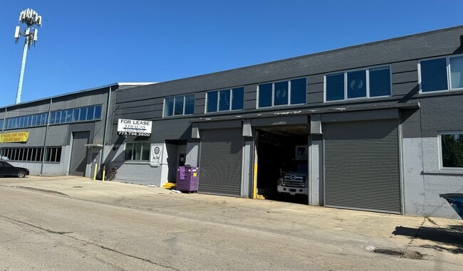

This Property Is For Sale
Current Lease Availabilities
NEARBY LISTINGS FOR SALE OR LEASE
Property Detail
4715 N Lamon Ave
Chicago-Naperville-Elgin, IL-IN-WI
Creightons Add To Chicago
13-16-206-002-0000
(CREIGHTONS) ADD TO (CHICAGO) SUB BLK PT LT 32 OF MON TROSE SUB OF NW NH SW & EH LT 1 OF SCHOOL TRUSTEES SUB E 40 ACS OF NH S
Industrialgeneral
Cook
X
Illinois
17031C0403J
1,32
2023
0.56 AC
2024
North Chicago
110502
Chicago
41,432 SF
DEMOGRAPHICS near 4715 N Lamon Ave
1 Mile
3 Mile
5 Mile
2024 Total Population
33,977
331,234
966,413
2029 Population
32,037
312,096
919,650
Pop Growth 2024-2029
(5.71%)
(5.78%)
(4.84%)
Average Age
40
40
39
2024 Total Households
13,343
121,667
377,148
HH Growth 2024-2029
(6.05%)
(6.13%)
(5.06%)
Median Household Inc
$82,071
$77,721
$77,709
Avg Household Size
2.50
2.60
2.50
2024 Avg HH Vehicles
2.00
2.00
1.00
Median Home Value
$367,684
$359,811
$361,755
Median Year Built
1947
1947
1948
Nearby Places
Map Layers
Map Styles
 Street
 Aerial
- Restaurants
- Banks
- Shops
- Fitness
- Groceries
PUBLIC TRANSPORTATION
TRANSIT/SUBWAY
Mayfair Station (Milwaukee District North Line - Northeast Illinois Regional Commuter Railroad (Metra))
DRIVE
WALK
Distance
Mayfair Station (Milwaukee District North Line - Northeast Illinois Regional Commuter Railroad (Metra))
2 min
12 min
0.6 mi
Jefferson Park Station (Blue Line - Chicago Transit Authority "L" Trains (The "L"))
DRIVE
WALK
Distance
Jefferson Park Station (Blue Line - Chicago Transit Authority "L" Trains (The "L"))
1 min
15 min
0.7 mi
Montrose Station (Blue Line) (Blue Line - Chicago Transit Authority "L" Trains (The "L"))
DRIVE
WALK
Distance
Montrose Station (Blue Line) (Blue Line - Chicago Transit Authority "L" Trains (The "L"))
4 min
15 min
0.8 mi
Jefferson Park Station (Union Pacific Northwest Line - Northeast Illinois Regional Commuter Railroad (Metra))
DRIVE
WALK
Distance
Jefferson Park Station (Union Pacific Northwest Line - Northeast Illinois Regional Commuter Railroad (Metra))
4 min
16 min
0.8 mi
Forest Glen Station (Milwaukee District North Line - Northeast Illinois Regional Commuter Railroad (Metra))
DRIVE
WALK
Distance
Forest Glen Station (Milwaukee District North Line - Northeast Illinois Regional Commuter Railroad (Metra))
2 min
19 min
1.0 mi
COMMUTER RAIL
Mayfair Station (Milwaukee District North Line - Northeast Illinois Regional Commuter Railroad (Metra))
DRIVE
WALK
Distance
Mayfair Station (Milwaukee District North Line - Northeast Illinois Regional Commuter Railroad (Metra))
2 min
13 min
0.6 mi
Jefferson Park Station (Union Pacific Northwest Line - Northeast Illinois Regional Commuter Railroad (Metra))
DRIVE
WALK
Distance
Jefferson Park Station (Union Pacific Northwest Line - Northeast Illinois Regional Commuter Railroad (Metra))
2 min
16 min
0.8 mi
AIRPORT
Chicago O'Hare International
DRIVE
WALK
Distance
Chicago O'Hare International
14 min
8.7 mi
Chicago Midway International
DRIVE
WALK
Distance
Chicago Midway International
26 min
14.3 mi
Nearby Properties
Address
Land Use
TOTAL SIZE
Lot Size
Zoning
Address
Land Use
TOTAL SIZE
Lot Size
Zoning
Address
Land Use
TOTAL SIZE
Lot Size
Zoning
21.56 AC
RS-2
Address
Land Use
TOTAL SIZE
Lot Size
Zoning
PD 184
Address
Land Use
TOTAL SIZE
Lot Size
Zoning
237,832 SF
14.04 AC
PD 418
Address
Land Use
TOTAL SIZE
Lot Size
Zoning
190,011 SF
5.90 AC
PD 353
Address
Land Use
TOTAL SIZE
Lot Size
Zoning
170,538 SF
0.76 AC
PD 112
Address
Land Use
TOTAL SIZE
Lot Size
Zoning
1.04 AC
PD 130
Address
Land Use
TOTAL SIZE
Lot Size
Zoning
201,600 SF
1.93 AC
PD 92
Address
Land Use
TOTAL SIZE
Lot Size
Zoning
9.38 AC
PD 1179,PO
Address
Land Use
TOTAL SIZE
Lot Size
Zoning
139.71 AC
PD 184
Address
Land Use
TOTAL SIZE
Lot Size
Zoning
15,600 SF
0.77 AC
M1-1
Address
Land Use
TOTAL SIZE
Lot Size
Zoning
100,900 SF
4.85 AC
PD 1415
Address
Land Use
TOTAL SIZE
Lot Size
Zoning
63,700 SF
7.42 AC
PD 796
Address
Land Use
TOTAL SIZE
Lot Size
Zoning
24,400 SF
0.50 AC
B3-2
Address
Land Use
TOTAL SIZE
Lot Size
Zoning
78,410 SF
4.87 AC
PD 171
Address
Land Use
TOTAL SIZE
Lot Size
Zoning
0.43 AC
RS-2
Address
Land Use
TOTAL SIZE
Lot Size
Zoning
67,588 SF
2.50 AC
PD 415
Address
Land Use
TOTAL SIZE
Lot Size
Zoning
83,288 SF
13.43 AC
RT-4
Address
Land Use
TOTAL SIZE
Lot Size
Zoning
43,750 SF
1.19 AC
B1-1
Address
Land Use
TOTAL SIZE
Lot Size
Zoning
68,831 SF
3.11 AC
PD 353
Address
Land Use
TOTAL SIZE
Lot Size
Zoning
92,380 SF
7.28 AC
RS-2
Address
Land Use
TOTAL SIZE
Lot Size
Zoning
1.20 AC
PD 92
Address
Land Use
TOTAL SIZE
Lot Size
Zoning
0.44 AC
RS-3
Address
Land Use
TOTAL SIZE
Lot Size
Zoning
36,800 SF
1.01 AC
C2-1
Address
Land Use
TOTAL SIZE
Lot Size
Zoning
124,706 SF
11.13 AC
PD 880
Address
Land Use
TOTAL SIZE
Lot Size
Zoning
71,133 SF
7.28 AC
PD 441
Address
Land Use
TOTAL SIZE
Lot Size
Zoning
63,344 SF
5.01 AC
PD 1069,M1
Address
Land Use
TOTAL SIZE
Lot Size
Zoning
306,872 SF
3.61 AC
PD 617
Address
Land Use
TOTAL SIZE
Lot Size
Zoning
113,877 SF
9.10 AC
PD 578
Address
Land Use
TOTAL SIZE
Lot Size
Zoning
0.77 AC
B3-2
The World's #1 Commercial Real Estate Marketplace
Connect with us
© 2025 CoStar Group
The information above has been obtained from sources believed reliable. While we do not doubt its accuracy we have not verified it and make no guarantee, warranty or representation about it. It is your responsibility to independently confirm its accuracy and completeness. Any projections, opinions, assumptions, or estimates used are for example only and do not represent the current or future performance of the property. The value of this transaction to you depends on tax and other factors which should be evaluated by your tax, financial, and legal advisors. You and your advisors should conduct a careful, independent investigation of the property to determine to your satisfaction the suitability of the property for your needs.