Property Record
47141 M 51, Decatur, MI 49045

Save to a Folder
{{folder.Name}}
{{folder.ListingIds.length}} Properties
{{folder.ListingIds.length}} Property
Create a New Folder
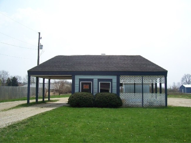
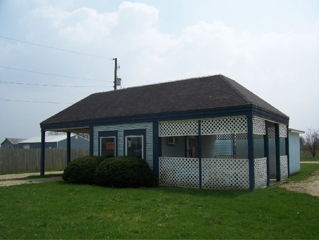
Property Detail
47141 M 51
Restaurantdrivein
227-J 25-4-15 798-750 851-547 1089-421 1523-528 1523-529 1635-347 *** COM AT N 1/4 PT OF SEC TH S 0 DEG 48'10"E ALG 1/4 L
C-2
Van Buren
B and X Area of moderate flood hazard, usually the area between the limits of the 100-year and 500-year floods.
Michigan
2024
1 AC
2025
Van Buren County
011500
West Michigan
940 SF
80-10-025-004-80
NEARBY LISTINGS FOR SALE OR LEASE
-
-
View all Decatur listings for sale on LoopNet.com
DEMOGRAPHICS near 47141 M 51
1 mile
3 mile
5 mile
2025 Total Population
274
2,997
5,013
2030 Population
273
2,974
5,024
Pop Growth 2025-2030
(0.36%)
(0.77%)
+ 0.22%
Average Age
43
42
43
2025 Total Households
109
1,181
1,963
HH Growth 2025-2030
(0.92%)
(1.10%)
0.00%
Median Household Inc
$61,500
$65,024
$65,375
Avg Household Size
2.50
2.50
2.50
2025 Avg HH Vehicles
2.00
2.00
2.00
Median Home Value
$187,930
$167,336
$181,941
Median Year Built
1969
1962
1968
Nearby Places
Map Layers
Map Styles
 Street
 Aerial
Layers
 Traffic
 Biking
Places
Listings with unknown addresses are not visible on the map
- Restaurants
- Banks
- Shops
- Fitness
- Groceries
PUBLIC TRANSPORTATION
AIRPORT
Kalamazoo/Battle Creek International
Drive
Walk
Distance
Kalamazoo/Battle Creek International
43 min
31.2 mi
South Bend International
Drive
Walk
Distance
South Bend International
68 min
41.7 mi
Nearby Properties
Address
Land Use
TOTAL SIZE
Lot Size
Zoning
Address
Land Use
TOTAL SIZE
Lot Size
Zoning
9,284 SF
2.31 AC
Address
Land Use
TOTAL SIZE
Lot Size
Zoning
4,810 SF
53.26 AC
C-1
Address
Land Use
TOTAL SIZE
Lot Size
Zoning
4,970 SF
269 AC
Address
Land Use
TOTAL SIZE
Lot Size
Zoning
2,172 SF
110.36 AC
AG
Address
Land Use
TOTAL SIZE
Lot Size
Zoning
2,160 SF
40 AC
Address
Land Use
TOTAL SIZE
Lot Size
Zoning
1,680 SF
32.97 AC
C-1
Address
Land Use
TOTAL SIZE
Lot Size
Zoning
4,970 SF
229 AC
Address
Land Use
TOTAL SIZE
Lot Size
Zoning
291.73 AC
AG
Address
Land Use
TOTAL SIZE
Lot Size
Zoning
Address
Land Use
TOTAL SIZE
Lot Size
Zoning
4,150 SF
160.88 AC
AG
Address
Land Use
TOTAL SIZE
Lot Size
Zoning
2,522 SF
189.06 AC
Address
Land Use
TOTAL SIZE
Lot Size
Zoning
11,796 SF
2.12 AC
Address
Land Use
TOTAL SIZE
Lot Size
Zoning
101,880 SF
3.30 AC
Address
Land Use
TOTAL SIZE
Lot Size
Zoning
161.43 AC
Address
Land Use
TOTAL SIZE
Lot Size
Zoning
0.88 AC
Address
Land Use
TOTAL SIZE
Lot Size
Zoning
3,233 SF
20.30 AC
C-1
Address
Land Use
TOTAL SIZE
Lot Size
Zoning
2,283 SF
44 AC
C-1
Address
Land Use
TOTAL SIZE
Lot Size
Zoning
218 AC
AG
Address
Land Use
TOTAL SIZE
Lot Size
Zoning
130 AC
Address
Land Use
TOTAL SIZE
Lot Size
Zoning
185.86 AC
AG
Address
Land Use
TOTAL SIZE
Lot Size
Zoning
176.14 AC
AG
Address
Land Use
TOTAL SIZE
Lot Size
Zoning
3,593 SF
79.46 AC
AG
Address
Land Use
TOTAL SIZE
Lot Size
Zoning
53,600 SF
Address
Land Use
TOTAL SIZE
Lot Size
Zoning
152.10 AC
Address
Land Use
TOTAL SIZE
Lot Size
Zoning
80,044 SF
2.67 AC
Address
Land Use
TOTAL SIZE
Lot Size
Zoning
148.49 AC
AG
Address
Land Use
TOTAL SIZE
Lot Size
Zoning
2,688 SF
38.84 AC
AG
Address
Land Use
TOTAL SIZE
Lot Size
Zoning
139.58 AC
Address
Land Use
TOTAL SIZE
Lot Size
Zoning
131.52 AC
Address
Land Use
TOTAL SIZE
Lot Size
Zoning
1,764 SF
96.96 AC
AG
The World's #1 Commercial Real Estate Marketplace
Connect with us
© 2026 CoStar Group
The information above has been obtained from sources believed reliable. While we do not doubt its accuracy we have not verified it and make no guarantee, warranty or representation about it. It is your responsibility to independently confirm its accuracy and completeness. Any projections, opinions, assumptions, or estimates used are for example only and do not represent the current or future performance of the property. The value of this transaction to you depends on tax and other factors which should be evaluated by your tax, financial, and legal advisors. You and your advisors should conduct a careful, independent investigation of the property to determine to your satisfaction the suitability of the property for your needs.