Property Record
47149 Conrad E Anderson St, Hammond, LA 70401
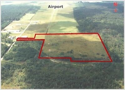

Property Detail
47149 Conrad E Anderson St
Hammond, LA
40.57A IN SEC 8 T6SR8E B536 P573 B627 P318 B853 P480 B852 P317 B854 P834 B942 P43 B947 P672 B1056 P523-529 B1101 P589 B1146 P
04162005
TANGIPAHOA
Residentialacreage
Louisiana
A Areas with a 1% annual chance of flooding and a 26% chance of flooding over the life of a 30-year mortgage.
40.57 AC
2025
Louisiana South Area
2025
Other Market Areas
954003
NEARBY LISTINGS FOR SALE OR LEASE
DEMOGRAPHICS near 47149 Conrad E Anderson St
1 mile
3 mile
5 mile
2025 Total Population
999
10,992
41,174
2030 Population
1,047
11,481
42,852
Pop Growth 2025-2030
+ 4.80%
+ 4.45%
+ 4.08%
Average Age
40
38
37
2025 Total Households
401
4,444
15,979
HH Growth 2025-2030
+ 4.99%
+ 4.59%
+ 4.32%
Median Household Inc
$60,405
$53,583
$51,635
Avg Household Size
2.40
2.40
2.40
2025 Avg HH Vehicles
2.00
2.00
2.00
Median Home Value
$344,375
$255,186
$231,122
Median Year Built
1997
1997
1992
Nearby Places
Map Layers
Map Styles
 Street
 Aerial
Transit
 Traffic
 Biking
Places
Listings with unknown addresses are not visible on the map
- Restaurants
- Banks
- Shops
- Fitness
- Groceries
PUBLIC TRANSPORTATION
COMMUTER RAIL
Hammond Amtrak Station (City of New Orleans - Amtrak)
Drive
Walk
Distance
Hammond Amtrak Station (City of New Orleans - Amtrak)
10 min
4.8 mi
Freight Ports
Port of Greater Baton Rouge
Drive
Walk
Distance
Port of Greater Baton Rouge
70 min
54.0 mi
Nearby Properties
Address
Land Use
TOTAL SIZE
Lot Size
Zoning
Address
Land Use
TOTAL SIZE
Lot Size
Zoning
309,554 SF
98.69 AC
Address
Land Use
TOTAL SIZE
Lot Size
Zoning
666,424 SF
82.56 AC
Address
Land Use
TOTAL SIZE
Lot Size
Zoning
624,811 SF
41.75 AC
Address
Land Use
TOTAL SIZE
Lot Size
Zoning
201,555 SF
11.17 AC
Address
Land Use
TOTAL SIZE
Lot Size
Zoning
165,402 SF
28.50 AC
Address
Land Use
TOTAL SIZE
Lot Size
Zoning
353.46 AC
Address
Land Use
TOTAL SIZE
Lot Size
Zoning
100,000 SF
6.32 AC
Address
Land Use
TOTAL SIZE
Lot Size
Zoning
62,962 SF
10.36 AC
Address
Land Use
TOTAL SIZE
Lot Size
Zoning
31,136 SF
3.30 AC
Address
Land Use
TOTAL SIZE
Lot Size
Zoning
52,200 SF
14.24 AC
Address
Land Use
TOTAL SIZE
Lot Size
Zoning
58,960 SF
8.88 AC
Address
Land Use
TOTAL SIZE
Lot Size
Zoning
68,000 SF
6.67 AC
Address
Land Use
TOTAL SIZE
Lot Size
Zoning
60,000 SF
11.76 AC
Address
Land Use
TOTAL SIZE
Lot Size
Zoning
5,700 SF
2.50 AC
Address
Land Use
TOTAL SIZE
Lot Size
Zoning
30,012 SF
2.51 AC
Address
Land Use
TOTAL SIZE
Lot Size
Zoning
56.15 AC
Address
Land Use
TOTAL SIZE
Lot Size
Zoning
15,060 SF
2.97 AC
Address
Land Use
TOTAL SIZE
Lot Size
Zoning
12,000 SF
1 AC
Address
Land Use
TOTAL SIZE
Lot Size
Zoning
20.03 AC
Address
Land Use
TOTAL SIZE
Lot Size
Zoning
31,250 SF
6.99 AC
Address
Land Use
TOTAL SIZE
Lot Size
Zoning
12,960 SF
31.95 AC
Address
Land Use
TOTAL SIZE
Lot Size
Zoning
176.32 AC
Address
Land Use
TOTAL SIZE
Lot Size
Zoning
21,800 SF
3.95 AC
Address
Land Use
TOTAL SIZE
Lot Size
Zoning
12,000 SF
1 AC
Address
Land Use
TOTAL SIZE
Lot Size
Zoning
43,757 SF
4.24 AC
Address
Land Use
TOTAL SIZE
Lot Size
Zoning
3,965 SF
1.53 AC
Address
Land Use
TOTAL SIZE
Lot Size
Zoning
9,310 SF
1.61 AC
Address
Land Use
TOTAL SIZE
Lot Size
Zoning
8,003 SF
0.90 AC
Address
Land Use
TOTAL SIZE
Lot Size
Zoning
23,221 SF
3 AC
Address
Land Use
TOTAL SIZE
Lot Size
Zoning
7,750 SF
1.02 AC
The World's #1 Commercial Real Estate Marketplace
Connect with us
© 2026 CoStar Group
The information above has been obtained from sources believed reliable. While we do not doubt its accuracy we have not verified it and make no guarantee, warranty or representation about it. It is your responsibility to independently confirm its accuracy and completeness. Any projections, opinions, assumptions, or estimates used are for example only and do not represent the current or future performance of the property. The value of this transaction to you depends on tax and other factors which should be evaluated by your tax, financial, and legal advisors. You and your advisors should conduct a careful, independent investigation of the property to determine to your satisfaction the suitability of the property for your needs.