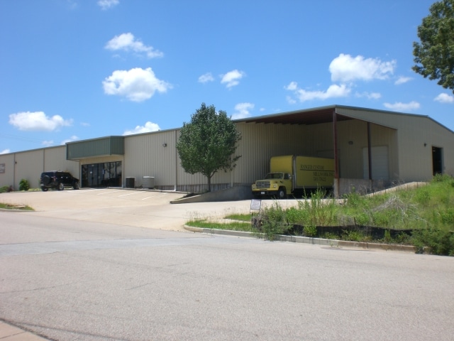
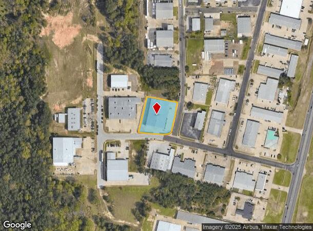
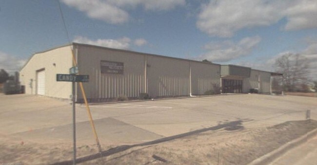
Property Record
4715 Candy Ln, Tyler, TX 75701
NEARBY LISTINGS FOR SALE OR LEASE
Property Detail
4715 Candy Ln
Tyler, TX
Candy Park U-8
1-50000-1550-05-001010
CANDY PARK U-8BLOCK 1550-E LOT 1A
Warehouse
Smith
X
Texas
48423C0365D
1a
2024
1.04 AC
2025
Tyler & Longview
001917
Other Market Areas
21,735 SF
DEMOGRAPHICS near 4715 Candy Ln
1 Mile
3 Mile
5 Mile
2024 Total Population
5,171
47,889
109,834
2029 Population
5,575
51,970
119,418
Pop Growth 2024-2029
+ 7.81%
+ 8.52%
+ 8.73%
Average Age
43
41
39
2024 Total Households
2,637
20,855
43,456
HH Growth 2024-2029
+ 7.47%
+ 7.94%
+ 8.21%
Median Household Inc
$51,043
$64,851
$61,423
Avg Household Size
1.90
2.20
2.40
2024 Avg HH Vehicles
2.00
2.00
2.00
Median Home Value
$199,033
$240,415
$203,842
Median Year Built
1994
1985
1981
Nearby Places
Map Layers
Map Styles
 Street
 Aerial
- Restaurants
- Banks
- Shops
- Fitness
- Groceries
PUBLIC TRANSPORTATION
AIRPORT
Tyler Pounds Regional
DRIVE
WALK
Distance
Tyler Pounds Regional
19 min
10.3 mi
Nearby Properties
Address
Land Use
TOTAL SIZE
Lot Size
Zoning
Address
Land Use
TOTAL SIZE
Lot Size
Zoning
18.37 AC
R1A
Address
Land Use
TOTAL SIZE
Lot Size
Zoning
403,396 SF
45.40 AC
C4
Address
Land Use
TOTAL SIZE
Lot Size
Zoning
11,332 SF
22.07 AC
PMF
Address
Land Use
TOTAL SIZE
Lot Size
Zoning
168,390 SF
7.51 AC
Address
Land Use
TOTAL SIZE
Lot Size
Zoning
24.83 AC
Address
Land Use
TOTAL SIZE
Lot Size
Zoning
29.58 AC
Address
Land Use
TOTAL SIZE
Lot Size
Zoning
234,762 SF
16.68 AC
Address
Land Use
TOTAL SIZE
Lot Size
Zoning
5,068 SF
18.35 AC
RMF
Address
Land Use
TOTAL SIZE
Lot Size
Zoning
84,560 SF
15.70 AC
M1
Address
Land Use
TOTAL SIZE
Lot Size
Zoning
4,333 SF
13.32 AC
Address
Land Use
TOTAL SIZE
Lot Size
Zoning
3,149 SF
16.15 AC
RMF
Address
Land Use
TOTAL SIZE
Lot Size
Zoning
4,349 SF
33.26 AC
RMF
Address
Land Use
TOTAL SIZE
Lot Size
Zoning
Address
Land Use
TOTAL SIZE
Lot Size
Zoning
237,916 SF
11.17 AC
PMF
Address
Land Use
TOTAL SIZE
Lot Size
Zoning
3,189 SF
11.17 AC
RMF
Address
Land Use
TOTAL SIZE
Lot Size
Zoning
66.86 AC
R1A
Address
Land Use
TOTAL SIZE
Lot Size
Zoning
10.51 AC
Address
Land Use
TOTAL SIZE
Lot Size
Zoning
37,536 SF
16.81 AC
RMF
Address
Land Use
TOTAL SIZE
Lot Size
Zoning
88,964 SF
11.33 AC
Address
Land Use
TOTAL SIZE
Lot Size
Zoning
1,867 SF
13.63 AC
RMF
Address
Land Use
TOTAL SIZE
Lot Size
Zoning
3,968 SF
12.04 AC
RMF
Address
Land Use
TOTAL SIZE
Lot Size
Zoning
43,692 SF
4.02 AC
Address
Land Use
TOTAL SIZE
Lot Size
Zoning
126.94 AC
Address
Land Use
TOTAL SIZE
Lot Size
Zoning
3,538 SF
9.51 AC
RMF
Address
Land Use
TOTAL SIZE
Lot Size
Zoning
90,410 SF
4.94 AC
Address
Land Use
TOTAL SIZE
Lot Size
Zoning
3,806 SF
18.86 AC
RMF
Address
Land Use
TOTAL SIZE
Lot Size
Zoning
14,752 SF
9.64 AC
RMF
Address
Land Use
TOTAL SIZE
Lot Size
Zoning
3,477 SF
9.56 AC
RMF
Address
Land Use
TOTAL SIZE
Lot Size
Zoning
2,936 SF
9.66 AC
RMF
Address
Land Use
TOTAL SIZE
Lot Size
Zoning
52,557 SF
11.44 AC
RMF
The World's #1 Commercial Real Estate Marketplace
Connect with us
© 2026 CoStar Group
The information above has been obtained from sources believed reliable. While we do not doubt its accuracy we have not verified it and make no guarantee, warranty or representation about it. It is your responsibility to independently confirm its accuracy and completeness. Any projections, opinions, assumptions, or estimates used are for example only and do not represent the current or future performance of the property. The value of this transaction to you depends on tax and other factors which should be evaluated by your tax, financial, and legal advisors. You and your advisors should conduct a careful, independent investigation of the property to determine to your satisfaction the suitability of the property for your needs.