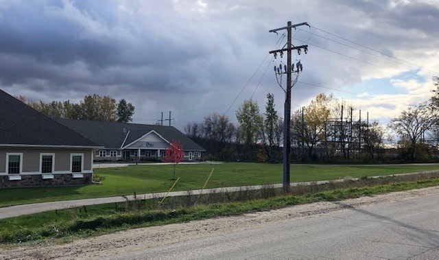
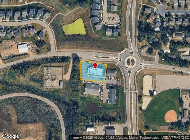
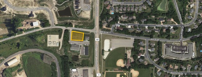
Property Record
4715 Dahlgren Rd, Carver, MN 55315
NEARBY LISTINGS FOR SALE OR LEASE
Property Detail
4715 Dahlgren Rd
Minneapolis-St. Paul-Bloomington, MN-WI
Carver Square
20.1160010
Carver
Commercialnec
Minnesota
X
1
27019C0219D
0.81 AC
2025
Carver County Outlying
2025
Minneapolis/St Paul
091100
DEMOGRAPHICS near 4715 Dahlgren Rd
1 Mile
3 Mile
5 Mile
2024 Total Population
4,966
11,883
37,533
2029 Population
5,504
13,165
40,882
Pop Growth 2024-2029
+ 10.83%
+ 10.79%
+ 8.92%
Average Age
36
36
38
2024 Total Households
1,628
4,024
13,447
HH Growth 2024-2029
+ 11.12%
+ 10.59%
+ 8.85%
Median Household Inc
$103,705
$106,993
$93,129
Avg Household Size
3.00
2.90
2.70
2024 Avg HH Vehicles
2.00
2.00
2.00
Median Home Value
$368,137
$392,307
$355,048
Median Year Built
2004
2003
1996
Nearby Places
- Restaurants
- Banks
- Shops
- Fitness
- Groceries
PUBLIC TRANSPORTATION
AIRPORT
Minneapolis-St Paul International/Wold-Chamberlain
DRIVE
WALK
Distance
Minneapolis-St Paul International/Wold-Chamberlain
36 min
26.4 mi
Freight Ports
Port Milwaukee
DRIVE
WALK
Distance
Port Milwaukee
404 min
363.6 mi
SALE & LEASE HISTORY
LISTING DATE
SALE/LEASE

Oct 18, 2019
For Sale
Jul 23, 2021
For Sale
Nearby Properties
Address
Land Use
TOTAL SIZE
Lot Size
Zoning
Address
Land Use
TOTAL SIZE
Lot Size
Zoning
20.18 AC
Address
Land Use
TOTAL SIZE
Lot Size
Zoning
10.40 AC
Address
Land Use
TOTAL SIZE
Lot Size
Zoning
17.50 AC
Address
Land Use
TOTAL SIZE
Lot Size
Zoning
1.11 AC
Address
Land Use
TOTAL SIZE
Lot Size
Zoning
33,982 SF
0.38 AC
Address
Land Use
TOTAL SIZE
Lot Size
Zoning
3.75 AC
Address
Land Use
TOTAL SIZE
Lot Size
Zoning
255,630 SF
27.07 AC
Address
Land Use
TOTAL SIZE
Lot Size
Zoning
92,380 SF
20.05 AC
I-2
Address
Land Use
TOTAL SIZE
Lot Size
Zoning
100.55 AC
Address
Land Use
TOTAL SIZE
Lot Size
Zoning
157.60 AC
I-1
Address
Land Use
TOTAL SIZE
Lot Size
Zoning
83.14 AC
Address
Land Use
TOTAL SIZE
Lot Size
Zoning
5,940 SF
1.52 AC
Address
Land Use
TOTAL SIZE
Lot Size
Zoning
13,383 SF
1.05 AC
Address
Land Use
TOTAL SIZE
Lot Size
Zoning
11,616 SF
1.75 AC
Address
Land Use
TOTAL SIZE
Lot Size
Zoning
2.10 AC
Address
Land Use
TOTAL SIZE
Lot Size
Zoning
480 SF
278.98 AC
Address
Land Use
TOTAL SIZE
Lot Size
Zoning
67,789 SF
5.18 AC
I-2
Address
Land Use
TOTAL SIZE
Lot Size
Zoning
9,381 SF
1.12 AC
Address
Land Use
TOTAL SIZE
Lot Size
Zoning
46,050 SF
24.36 AC
Address
Land Use
TOTAL SIZE
Lot Size
Zoning
10,325 SF
0.70 AC
Address
Land Use
TOTAL SIZE
Lot Size
Zoning
50,470 SF
13.14 AC
I-2
Address
Land Use
TOTAL SIZE
Lot Size
Zoning
91.80 AC
I-2
Address
Land Use
TOTAL SIZE
Lot Size
Zoning
12,887 SF
1.04 AC
Address
Land Use
TOTAL SIZE
Lot Size
Zoning
100.80 AC
I-2
Address
Land Use
TOTAL SIZE
Lot Size
Zoning
39.34 AC
Address
Land Use
TOTAL SIZE
Lot Size
Zoning
111.09 AC
I-2
Address
Land Use
TOTAL SIZE
Lot Size
Zoning
13,876 SF
0.40 AC
Address
Land Use
TOTAL SIZE
Lot Size
Zoning
12,380 SF
0.84 AC
Address
Land Use
TOTAL SIZE
Lot Size
Zoning
1.60 AC
Address
Land Use
TOTAL SIZE
Lot Size
Zoning
11,520 SF
1.23 AC
The World's #1 Commercial Real Estate Marketplace
Connect with us
© 2025 CoStar Group
The information above has been obtained from sources believed reliable. While we do not doubt its accuracy we have not verified it and make no guarantee, warranty or representation about it. It is your responsibility to independently confirm its accuracy and completeness. Any projections, opinions, assumptions, or estimates used are for example only and do not represent the current or future performance of the property. The value of this transaction to you depends on tax and other factors which should be evaluated by your tax, financial, and legal advisors. You and your advisors should conduct a careful, independent investigation of the property to determine to your satisfaction the suitability of the property for your needs.