Property Record
4715 Highway 84 Rd, Lubbock, TX 79416
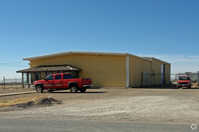


Property Detail
4715 Highway 84 Rd
Lubbock, TX
BLK A SEC 14 AB 861 TR 3 & 4A MCCOLLUM AC: 2.05
R164364
Lubbock
Storebuilding
Texas
C and X Area of minimal flood hazard, usually depicted on FIRMs as above the 500-year flood level.
187
2024
2.05 AC
2025
Outlying Lubbock County
000201
Lubbock
5,100 SF
NEARBY LISTINGS FOR SALE OR LEASE
DEMOGRAPHICS near 4715 Highway 84 Rd
1 mile
3 mile
5 mile
2025 Total Population
1,838
33,621
105,898
2030 Population
1,931
34,701
110,038
Pop Growth 2025-2030
+ 5.06%
+ 3.21%
+ 3.91%
Average Age
33
34
34
2025 Total Households
609
13,112
40,484
HH Growth 2025-2030
+ 5.42%
+ 3.49%
+ 4.55%
Median Household Inc
$57,409
$50,245
$47,688
Avg Household Size
2.80
2.50
2.30
2025 Avg HH Vehicles
2.00
2.00
2.00
Median Home Value
$243,233
$195,990
$182,242
Median Year Built
2004
1992
1982
Nearby Places
Map Layers
Map Styles
 Street
 Aerial
Transit
 Traffic
 Biking
Places
Listings with unknown addresses are not visible on the map
- Restaurants
- Banks
- Shops
- Fitness
- Groceries
PUBLIC TRANSPORTATION
AIRPORT
Lubbock Preston Smith International
Drive
Walk
Distance
Lubbock Preston Smith International
25 min
13.6 mi
Nearby Properties
Address
Land Use
TOTAL SIZE
Lot Size
Zoning
Address
Land Use
TOTAL SIZE
Lot Size
Zoning
103,717 SF
25.26 AC
Address
Land Use
TOTAL SIZE
Lot Size
Zoning
380,785 SF
36.72 AC
Address
Land Use
TOTAL SIZE
Lot Size
Zoning
379,029 SF
29.43 AC
Address
Land Use
TOTAL SIZE
Lot Size
Zoning
409,380 SF
30.13 AC
Address
Land Use
TOTAL SIZE
Lot Size
Zoning
360,108 SF
18.63 AC
Address
Land Use
TOTAL SIZE
Lot Size
Zoning
304,276 SF
22.69 AC
Address
Land Use
TOTAL SIZE
Lot Size
Zoning
244,983 SF
14.26 AC
Address
Land Use
TOTAL SIZE
Lot Size
Zoning
274,547 SF
18.92 AC
Address
Land Use
TOTAL SIZE
Lot Size
Zoning
473,857 SF
17.64 AC
Address
Land Use
TOTAL SIZE
Lot Size
Zoning
355,384 SF
19.63 AC
Address
Land Use
TOTAL SIZE
Lot Size
Zoning
244,834 SF
14.54 AC
Address
Land Use
TOTAL SIZE
Lot Size
Zoning
122,976 SF
14.50 AC
Address
Land Use
TOTAL SIZE
Lot Size
Zoning
88,803 SF
7.23 AC
Address
Land Use
TOTAL SIZE
Lot Size
Zoning
207.36 AC
Address
Land Use
TOTAL SIZE
Lot Size
Zoning
102,209 SF
14 AC
Address
Land Use
TOTAL SIZE
Lot Size
Zoning
67,759 SF
6.37 AC
Address
Land Use
TOTAL SIZE
Lot Size
Zoning
231,940 SF
7.67 AC
Address
Land Use
TOTAL SIZE
Lot Size
Zoning
41,592 SF
13.72 AC
Address
Land Use
TOTAL SIZE
Lot Size
Zoning
625.50 AC
Address
Land Use
TOTAL SIZE
Lot Size
Zoning
205,567 SF
34.16 AC
Address
Land Use
TOTAL SIZE
Lot Size
Zoning
183,541 SF
10.02 AC
Address
Land Use
TOTAL SIZE
Lot Size
Zoning
218,180 SF
25.87 AC
Address
Land Use
TOTAL SIZE
Lot Size
Zoning
948,414 SF
92.10 AC
Address
Land Use
TOTAL SIZE
Lot Size
Zoning
205,734 SF
10.61 AC
Address
Land Use
TOTAL SIZE
Lot Size
Zoning
425,004 SF
19.88 AC
Address
Land Use
TOTAL SIZE
Lot Size
Zoning
33,840 SF
2.50 AC
Address
Land Use
TOTAL SIZE
Lot Size
Zoning
24,800 SF
6.74 AC
Address
Land Use
TOTAL SIZE
Lot Size
Zoning
150,000 SF
13.65 AC
Address
Land Use
TOTAL SIZE
Lot Size
Zoning
21,121 SF
3.09 AC
Address
Land Use
TOTAL SIZE
Lot Size
Zoning
32,819 SF
4.25 AC
The World's #1 Commercial Real Estate Marketplace
Connect with us
© 2026 CoStar Group
The information above has been obtained from sources believed reliable. While we do not doubt its accuracy we have not verified it and make no guarantee, warranty or representation about it. It is your responsibility to independently confirm its accuracy and completeness. Any projections, opinions, assumptions, or estimates used are for example only and do not represent the current or future performance of the property. The value of this transaction to you depends on tax and other factors which should be evaluated by your tax, financial, and legal advisors. You and your advisors should conduct a careful, independent investigation of the property to determine to your satisfaction the suitability of the property for your needs.