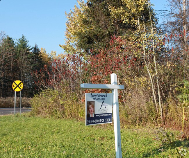
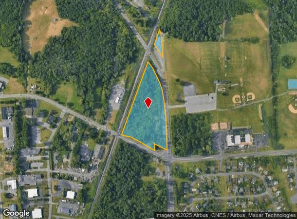
Property Record
4717 Wetzel Rd, Liverpool, NY 13090
NEARBY LISTINGS FOR SALE OR LEASE
Property Detail
4717 Wetzel Rd
312489-082-000-0001-004-001-0000
FL 62
Gasolinefuelbulkstorage
Onondaga
X
New York
36067C0089F
4.001
2025
7.78 AC
2024
NE Outer Onondaga County
011101
Syracuse
6,500 SF
Syracuse, NY
DEMOGRAPHICS near 4717 Wetzel Rd
1 Mile
3 Mile
5 Mile
2024 Total Population
2,792
52,787
103,159
2029 Population
2,712
51,266
100,398
Pop Growth 2024-2029
(2.87%)
(2.88%)
(2.68%)
Average Age
42
41
42
2024 Total Households
1,048
22,055
44,047
HH Growth 2024-2029
(3.05%)
(3.03%)
(2.86%)
Median Household Inc
$113,186
$77,560
$72,599
Avg Household Size
2.60
2.30
2.30
2024 Avg HH Vehicles
2.00
2.00
2.00
Median Home Value
$198,852
$169,131
$162,073
Median Year Built
1984
1974
1971
Nearby Places
- Restaurants
- Banks
- Shops
- Fitness
- Groceries
PUBLIC TRANSPORTATION
COMMUTER RAIL
Syracuse Regional Transportation Center (Empire Service - Amtrak, Lake Shore Limited - Amtrak, Maple Leaf - Amtrak)
DRIVE
WALK
Distance
Syracuse Regional Transportation Center (Empire Service - Amtrak, Lake Shore Limited - Amtrak, Maple Leaf - Amtrak)
11 min
6.2 mi
Syracuse (Toronto - New York - VIA Rail)
DRIVE
WALK
Distance
Syracuse (Toronto - New York - VIA Rail)
12 min
6.2 mi
AIRPORT
Syracuse Hancock International
DRIVE
WALK
Distance
Syracuse Hancock International
13 min
5.8 mi
Freight Ports
Albany, NY Port
DRIVE
WALK
Distance
Albany, NY Port
176 min
148.0 mi
SALE & LEASE HISTORY
LISTING DATE
SALE/LEASE

Sep 24, 2016
For Sale
Jan 01, 2021
For Sale
Nearby Properties
Address
Land Use
TOTAL SIZE
Lot Size
Zoning
Address
Land Use
TOTAL SIZE
Lot Size
Zoning
77,150 SF
159.25 AC
06 - INDUS
Address
Land Use
TOTAL SIZE
Lot Size
Zoning
7,229 SF
111.29 AC
05 - COMME
Address
Land Use
TOTAL SIZE
Lot Size
Zoning
3.59 AC
04 - FARM
Address
Land Use
TOTAL SIZE
Lot Size
Zoning
32,586 SF
6.87 AC
06 - INDUS
Address
Land Use
TOTAL SIZE
Lot Size
Zoning
57,993 SF
18.43 AC
02 - SINGL
Address
Land Use
TOTAL SIZE
Lot Size
Zoning
3,744 SF
10.60 AC
03 - MULTI
Address
Land Use
TOTAL SIZE
Lot Size
Zoning
11,059 SF
8.23 AC
06 - INDUS
Address
Land Use
TOTAL SIZE
Lot Size
Zoning
57,993 SF
16.80 AC
02 - SINGL
Address
Land Use
TOTAL SIZE
Lot Size
Zoning
14,508 SF
8.74 AC
03 - MULTI
Address
Land Use
TOTAL SIZE
Lot Size
Zoning
210,170 SF
17.87 AC
06 - INDUS
Address
Land Use
TOTAL SIZE
Lot Size
Zoning
8,992 SF
6.63 AC
06 - INDUS
Address
Land Use
TOTAL SIZE
Lot Size
Zoning
11,059 SF
5.30 AC
06 - INDUS
Address
Land Use
TOTAL SIZE
Lot Size
Zoning
82,071 SF
6.29 AC
06 - INDUS
Address
Land Use
TOTAL SIZE
Lot Size
Zoning
45,228 SF
26.84 AC
04 - FARM
Address
Land Use
TOTAL SIZE
Lot Size
Zoning
10,983 SF
3.49 AC
06 - INDUS
Address
Land Use
TOTAL SIZE
Lot Size
Zoning
309,390 SF
68.49 AC
05 - COMME
Address
Land Use
TOTAL SIZE
Lot Size
Zoning
48,658 SF
0.01 AC
02 - SINGL
Address
Land Use
TOTAL SIZE
Lot Size
Zoning
50,492 SF
11.01 AC
06 - INDUS
Address
Land Use
TOTAL SIZE
Lot Size
Zoning
60,532 SF
4.69 AC
06 - INDUS
Address
Land Use
TOTAL SIZE
Lot Size
Zoning
33,962 SF
12.04 AC
03 - MULTI
Address
Land Use
TOTAL SIZE
Lot Size
Zoning
59,146 SF
5.02 AC
06 - INDUS
Address
Land Use
TOTAL SIZE
Lot Size
Zoning
27,074 SF
3.23 AC
06 - INDUS
Address
Land Use
TOTAL SIZE
Lot Size
Zoning
3,600 SF
2.14 AC
02 - SINGL
Address
Land Use
TOTAL SIZE
Lot Size
Zoning
47,783 SF
2.22 AC
06 - INDUS
Address
Land Use
TOTAL SIZE
Lot Size
Zoning
22,518 SF
4.95 AC
06 - INDUS
Address
Land Use
TOTAL SIZE
Lot Size
Zoning
61,542 SF
4.25 AC
04 - FARM
Address
Land Use
TOTAL SIZE
Lot Size
Zoning
60,625 SF
4.08 AC
06 - INDUS
Address
Land Use
TOTAL SIZE
Lot Size
Zoning
18,814 SF
3.26 AC
02 - SINGL
Address
Land Use
TOTAL SIZE
Lot Size
Zoning
909,548 SF
61.81 AC
06 - INDUS
Address
Land Use
TOTAL SIZE
Lot Size
Zoning
18,662 SF
4.73 AC
06 - INDUS
The World's #1 Commercial Real Estate Marketplace
Connect with us
© 2025 CoStar Group
The information above has been obtained from sources believed reliable. While we do not doubt its accuracy we have not verified it and make no guarantee, warranty or representation about it. It is your responsibility to independently confirm its accuracy and completeness. Any projections, opinions, assumptions, or estimates used are for example only and do not represent the current or future performance of the property. The value of this transaction to you depends on tax and other factors which should be evaluated by your tax, financial, and legal advisors. You and your advisors should conduct a careful, independent investigation of the property to determine to your satisfaction the suitability of the property for your needs.