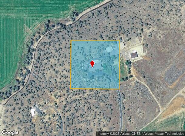
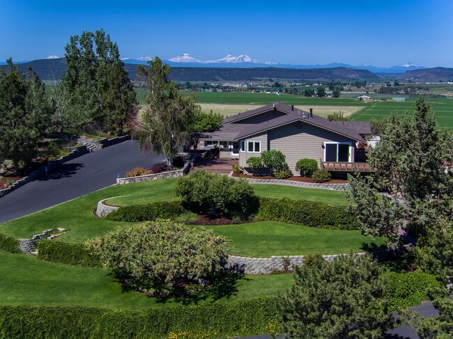
Property Record
4720 N Mckay Rd, Prineville, OR 97754

NEARBY LISTINGS FOR SALE OR LEASE
Property Detail
4720 N Mckay Rd
010875
SECTION 20 TOWNSHIP 14S RANGE 16E PCRL 104 MAPTAXLOT: 1416200000104
Farms
Crook
X
Oregon
41013C0405C
4.65 AC
2025
Bend/Redmond
2025
Other Market Areas
950102
Prineville, OR
6,308 SF
DEMOGRAPHICS near 4720 N Mckay Rd
1 Mile
3 Mile
5 Mile
2024 Total Population
177
8,990
15,771
2029 Population
206
10,529
18,400
Pop Growth 2024-2029
+ 16.38%
+ 17.12%
+ 16.67%
Average Age
45
42
42
2024 Total Households
71
3,581
6,258
HH Growth 2024-2029
+ 15.49%
+ 17.34%
+ 16.91%
Median Household Inc
$74,062
$62,016
$60,092
Avg Household Size
2.50
2.50
2.50
2024 Avg HH Vehicles
2.00
2.00
2.00
Median Home Value
$422,222
$344,857
$331,994
Median Year Built
1995
1990
1981
Nearby Places
Map Layers
Map Styles
 Street
 Aerial
- Restaurants
- Banks
- Shops
- Fitness
- Groceries
PUBLIC TRANSPORTATION
AIRPORT
Roberts Field
DRIVE
WALK
Distance
Roberts Field
33 min
22.2 mi
Freight Ports
Port of Portland
DRIVE
WALK
Distance
Port of Portland
231 min
150.5 mi
SALE & LEASE HISTORY
LISTING DATE
SALE/LEASE

Sep 06, 2017
For Sale
Nearby Properties
Address
Land Use
TOTAL SIZE
Lot Size
Zoning
Address
Land Use
TOTAL SIZE
Lot Size
Zoning
1 SF
15.01 AC
R2
Address
Land Use
TOTAL SIZE
Lot Size
Zoning
6.16 AC
R2
Address
Land Use
TOTAL SIZE
Lot Size
Zoning
1 SF
8.02 AC
C2
Address
Land Use
TOTAL SIZE
Lot Size
Zoning
33,854 SF
1.52 AC
R4
Address
Land Use
TOTAL SIZE
Lot Size
Zoning
1 SF
2.24 AC
R2
Address
Land Use
TOTAL SIZE
Lot Size
Zoning
38,165 SF
1.38 AC
C2
Address
Land Use
TOTAL SIZE
Lot Size
Zoning
1 SF
13.67 AC
M2
Address
Land Use
TOTAL SIZE
Lot Size
Zoning
35,030 SF
2.90 AC
C2
Address
Land Use
TOTAL SIZE
Lot Size
Zoning
31,344 SF
2.39 AC
C2
Address
Land Use
TOTAL SIZE
Lot Size
Zoning
24,148 SF
1.55 AC
C2
Address
Land Use
TOTAL SIZE
Lot Size
Zoning
12,887 SF
0.70 AC
C1
Address
Land Use
TOTAL SIZE
Lot Size
Zoning
25,576 SF
1.50 AC
C2
Address
Land Use
TOTAL SIZE
Lot Size
Zoning
57,708 SF
7.63 AC
HM
Address
Land Use
TOTAL SIZE
Lot Size
Zoning
1 SF
22.48 AC
M2
Address
Land Use
TOTAL SIZE
Lot Size
Zoning
15,026 SF
0.18 AC
C1
Address
Land Use
TOTAL SIZE
Lot Size
Zoning
12,826 SF
0.54 AC
R2
Address
Land Use
TOTAL SIZE
Lot Size
Zoning
39,953 SF
2.07 AC
C2
Address
Land Use
TOTAL SIZE
Lot Size
Zoning
1 SF
2.51 AC
M2
Address
Land Use
TOTAL SIZE
Lot Size
Zoning
15,545 SF
2.32 AC
R4
Address
Land Use
TOTAL SIZE
Lot Size
Zoning
22,029 SF
15.85 AC
HM
Address
Land Use
TOTAL SIZE
Lot Size
Zoning
11,285 SF
1.20 AC
C2
Address
Land Use
TOTAL SIZE
Lot Size
Zoning
38,500 SF
3.42 AC
M1
Address
Land Use
TOTAL SIZE
Lot Size
Zoning
1 SF
6.89 AC
M1
Address
Land Use
TOTAL SIZE
Lot Size
Zoning
1 SF
8.12 AC
M2
Address
Land Use
TOTAL SIZE
Lot Size
Zoning
2,880 SF
2.84 AC
C2
Address
Land Use
TOTAL SIZE
Lot Size
Zoning
18,348 SF
1.95 AC
C2
Address
Land Use
TOTAL SIZE
Lot Size
Zoning
13,760 SF
3.96 AC
M1
Address
Land Use
TOTAL SIZE
Lot Size
Zoning
1 SF
6.05 AC
M2
Address
Land Use
TOTAL SIZE
Lot Size
Zoning
6,912 SF
6.42 AC
M1
Address
Land Use
TOTAL SIZE
Lot Size
Zoning
4,400 SF
0.89 AC
C2
The World's #1 Commercial Real Estate Marketplace
Connect with us
© 2026 CoStar Group
The information above has been obtained from sources believed reliable. While we do not doubt its accuracy we have not verified it and make no guarantee, warranty or representation about it. It is your responsibility to independently confirm its accuracy and completeness. Any projections, opinions, assumptions, or estimates used are for example only and do not represent the current or future performance of the property. The value of this transaction to you depends on tax and other factors which should be evaluated by your tax, financial, and legal advisors. You and your advisors should conduct a careful, independent investigation of the property to determine to your satisfaction the suitability of the property for your needs.