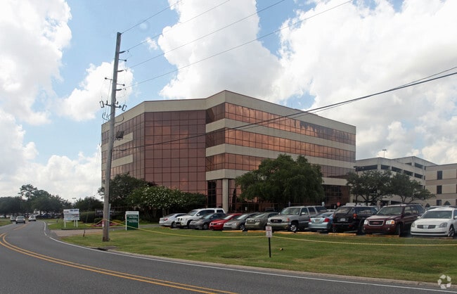
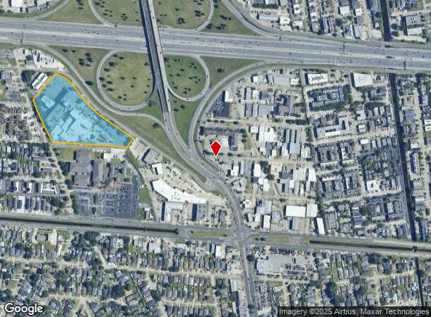
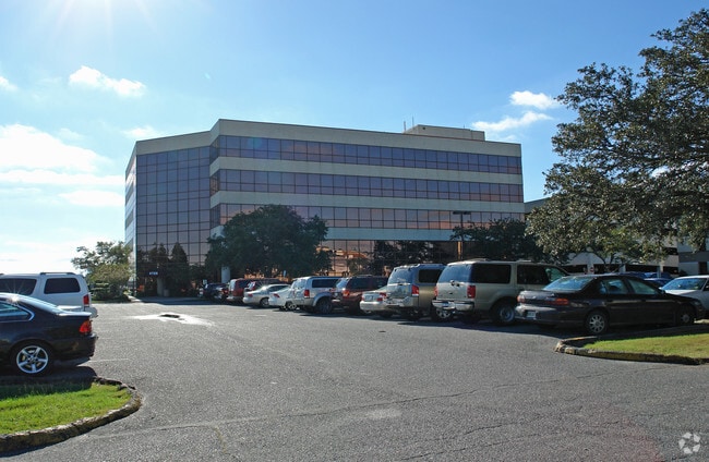
Property Record
4720 S I 10 Service Rd W, Metairie, LA 70001
Current Lease Availabilities
NEARBY LISTINGS FOR SALE OR LEASE
Property Detail
4720 S I 10 Service Rd W
New Orleans-Metairie, LA
Canal St
3822200704
Jefferson
Miscellaneous
Louisiana
AE
5a
22051C0185F
0.12 AC
2024
Metairie
2024
New Orleans/Metairie/Kenner
029900
DEMOGRAPHICS near 4720 S I 10 Service Rd W
1 Mile
3 Mile
5 Mile
2024 Total Population
24,301
135,635
257,148
2029 Population
23,273
130,229
247,114
Pop Growth 2024-2029
(4.23%)
(3.99%)
(3.90%)
Average Age
40
42
42
2024 Total Households
10,554
59,189
110,623
HH Growth 2024-2029
(4.42%)
(4.10%)
(4.05%)
Median Household Inc
$53,300
$63,298
$60,723
Avg Household Size
2.30
2.20
2.30
2024 Avg HH Vehicles
2.00
2.00
2.00
Median Home Value
$262,059
$270,124
$272,435
Median Year Built
1974
1970
1970
Nearby Places
- Restaurants
- Banks
- Shops
- Fitness
- Groceries
PUBLIC TRANSPORTATION
COMMUTER RAIL
New Orleans Union Passenger Terminal (City of New Orleans - Amtrak, Crescent - Amtrak, Sunset Limited - Amtrak)
DRIVE
WALK
Distance
New Orleans Union Passenger Terminal (City of New Orleans - Amtrak, Crescent - Amtrak, Sunset Limited - Amtrak)
13 min
8.9 mi
AIRPORT
Louis Armstrong New Orleans International
DRIVE
WALK
Distance
Louis Armstrong New Orleans International
12 min
7.0 mi
Freight Ports
Port of New Orleans
DRIVE
WALK
Distance
Port of New Orleans
19 min
10.9 mi
Nearby Properties
Address
Land Use
TOTAL SIZE
Lot Size
Zoning
Address
Land Use
TOTAL SIZE
Lot Size
Zoning
23.74 AC
R1A
Address
Land Use
TOTAL SIZE
Lot Size
Zoning
50.06 AC
R1A
Address
Land Use
TOTAL SIZE
Lot Size
Zoning
20.73 AC
Address
Land Use
TOTAL SIZE
Lot Size
Zoning
4.31 AC
BC2
Address
Land Use
TOTAL SIZE
Lot Size
Zoning
1.45 AC
M1
Address
Land Use
TOTAL SIZE
Lot Size
Zoning
42.34 AC
Address
Land Use
TOTAL SIZE
Lot Size
Zoning
Address
Land Use
TOTAL SIZE
Lot Size
Zoning
3.32 AC
FC3
Address
Land Use
TOTAL SIZE
Lot Size
Zoning
Address
Land Use
TOTAL SIZE
Lot Size
Zoning
7.98 AC
R1A
Address
Land Use
TOTAL SIZE
Lot Size
Zoning
2.56 AC
R2
Address
Land Use
TOTAL SIZE
Lot Size
Zoning
15.97 AC
Address
Land Use
TOTAL SIZE
Lot Size
Zoning
Address
Land Use
TOTAL SIZE
Lot Size
Zoning
19.35 AC
R1A
Address
Land Use
TOTAL SIZE
Lot Size
Zoning
66.02 AC
Address
Land Use
TOTAL SIZE
Lot Size
Zoning
Address
Land Use
TOTAL SIZE
Lot Size
Zoning
Address
Land Use
TOTAL SIZE
Lot Size
Zoning
4.90 AC
R2
Address
Land Use
TOTAL SIZE
Lot Size
Zoning
Address
Land Use
TOTAL SIZE
Lot Size
Zoning
0.20 AC
Address
Land Use
TOTAL SIZE
Lot Size
Zoning
0.12 AC
Address
Land Use
TOTAL SIZE
Lot Size
Zoning
14.56 AC
R1A
Address
Land Use
TOTAL SIZE
Lot Size
Zoning
Address
Land Use
TOTAL SIZE
Lot Size
Zoning
0.11 AC
Address
Land Use
TOTAL SIZE
Lot Size
Zoning
10.76 AC
C2
Address
Land Use
TOTAL SIZE
Lot Size
Zoning
Address
Land Use
TOTAL SIZE
Lot Size
Zoning
0.15 AC
Address
Land Use
TOTAL SIZE
Lot Size
Zoning
0.45 AC
Address
Land Use
TOTAL SIZE
Lot Size
Zoning
1.85 AC
GO2
Address
Land Use
TOTAL SIZE
Lot Size
Zoning
The World's #1 Commercial Real Estate Marketplace
Connect with us
© 2025 CoStar Group
The information above has been obtained from sources believed reliable. While we do not doubt its accuracy we have not verified it and make no guarantee, warranty or representation about it. It is your responsibility to independently confirm its accuracy and completeness. Any projections, opinions, assumptions, or estimates used are for example only and do not represent the current or future performance of the property. The value of this transaction to you depends on tax and other factors which should be evaluated by your tax, financial, and legal advisors. You and your advisors should conduct a careful, independent investigation of the property to determine to your satisfaction the suitability of the property for your needs.