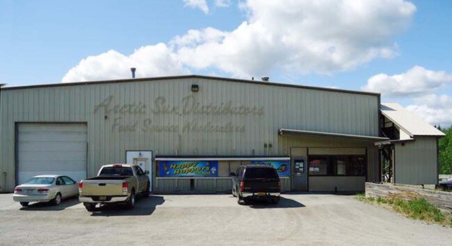
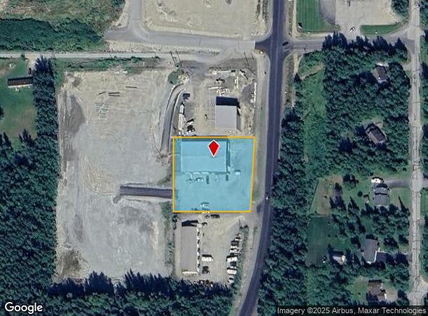
Property Record
4721 E Bogard Rd, Wasilla, AK 99654
NEARBY LISTINGS FOR SALE OR LEASE
-
-
View all Wasilla listings for sale on LoopNet.com
Property Detail
4721 E Bogard Rd
Anchorage, AK
Stoney Hollow
2702000L002
STONEY HOLLOW LOT 2
Warehouse
Matanuska-Susitna
X
Alaska
02170C8105F
2
2024
0.96 AC
2025
Mat-Su Business Region
001003
Anchorage
DEMOGRAPHICS near 4721 E Bogard Rd
1 Mile
3 Mile
5 Mile
2024 Total Population
3,032
20,110
45,836
2029 Population
3,440
23,002
52,489
Pop Growth 2024-2029
+ 13.46%
+ 14.38%
+ 14.51%
Average Age
37
37
37
2024 Total Households
1,048
7,095
16,210
HH Growth 2024-2029
+ 14.03%
+ 14.95%
+ 15.13%
Median Household Inc
$87,936
$85,159
$85,697
Avg Household Size
2.80
2.80
2.80
2024 Avg HH Vehicles
2.00
2.00
2.00
Median Home Value
$276,365
$299,090
$317,108
Median Year Built
1989
1996
2000
Nearby Places
Map Layers
Map Styles
 Street
 Aerial
- Restaurants
- Banks
- Shops
- Fitness
- Groceries
SALE & LEASE HISTORY
LISTING DATE
SALE/LEASE

Oct 29, 2018
For Sale
Aug 15, 2018
For Lease
Nearby Properties
Address
Land Use
TOTAL SIZE
Lot Size
Zoning
Address
Land Use
TOTAL SIZE
Lot Size
Zoning
93.14 AC
7
Address
Land Use
TOTAL SIZE
Lot Size
Zoning
1,831 SF
16.86 AC
35
Address
Land Use
TOTAL SIZE
Lot Size
Zoning
6.98 AC
7
Address
Land Use
TOTAL SIZE
Lot Size
Zoning
3.06 AC
7
Address
Land Use
TOTAL SIZE
Lot Size
Zoning
2.63 AC
7
Address
Land Use
TOTAL SIZE
Lot Size
Zoning
76.81 AC
7
Address
Land Use
TOTAL SIZE
Lot Size
Zoning
Address
Land Use
TOTAL SIZE
Lot Size
Zoning
137.13 AC
7
Address
Land Use
TOTAL SIZE
Lot Size
Zoning
Address
Land Use
TOTAL SIZE
Lot Size
Zoning
39.17 AC
7
Address
Land Use
TOTAL SIZE
Lot Size
Zoning
4.95 AC
7
Address
Land Use
TOTAL SIZE
Lot Size
Zoning
15 AC
7
Address
Land Use
TOTAL SIZE
Lot Size
Zoning
5.61 AC
7
Address
Land Use
TOTAL SIZE
Lot Size
Zoning
49,305 SF
5 AC
6
Address
Land Use
TOTAL SIZE
Lot Size
Zoning
7.06 AC
7
Address
Land Use
TOTAL SIZE
Lot Size
Zoning
28.65 AC
3
Address
Land Use
TOTAL SIZE
Lot Size
Zoning
13.20 AC
7
Address
Land Use
TOTAL SIZE
Lot Size
Zoning
2,636 SF
7.53 AC
17
Address
Land Use
TOTAL SIZE
Lot Size
Zoning
5.72 AC
7
Address
Land Use
TOTAL SIZE
Lot Size
Zoning
28,574 SF
13.08 AC
7
Address
Land Use
TOTAL SIZE
Lot Size
Zoning
59,201 SF
4.94 AC
17
Address
Land Use
TOTAL SIZE
Lot Size
Zoning
4.48 AC
35
Address
Land Use
TOTAL SIZE
Lot Size
Zoning
17,019 SF
2.16 AC
7
Address
Land Use
TOTAL SIZE
Lot Size
Zoning
10.89 AC
35
Address
Land Use
TOTAL SIZE
Lot Size
Zoning
19,466 SF
1.39 AC
7
Address
Land Use
TOTAL SIZE
Lot Size
Zoning
392 SF
12.15 AC
7
Address
Land Use
TOTAL SIZE
Lot Size
Zoning
3.52 AC
7
Address
Land Use
TOTAL SIZE
Lot Size
Zoning
2.31 AC
6
Address
Land Use
TOTAL SIZE
Lot Size
Zoning
11,588 SF
1.76 AC
6
Address
Land Use
TOTAL SIZE
Lot Size
Zoning
29.68 AC
The World's #1 Commercial Real Estate Marketplace
Connect with us
© 2026 CoStar Group
The information above has been obtained from sources believed reliable. While we do not doubt its accuracy we have not verified it and make no guarantee, warranty or representation about it. It is your responsibility to independently confirm its accuracy and completeness. Any projections, opinions, assumptions, or estimates used are for example only and do not represent the current or future performance of the property. The value of this transaction to you depends on tax and other factors which should be evaluated by your tax, financial, and legal advisors. You and your advisors should conduct a careful, independent investigation of the property to determine to your satisfaction the suitability of the property for your needs.