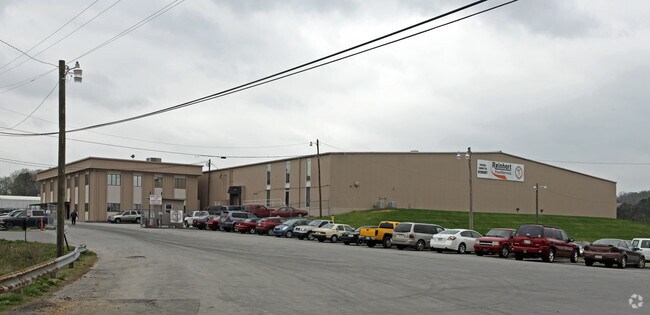
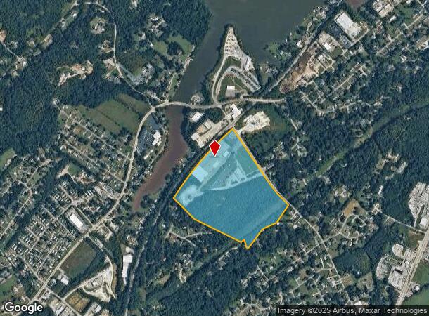
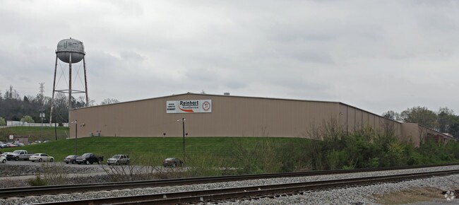
Property Record
4721 Singleton Station Rd, Louisville, TN 37777
NEARBY LISTINGS FOR SALE OR LEASE
Property Detail
4721 Singleton Station Rd
008-096.00-001
48.03AC ON 000(RESID)
Warehouse
Blount
X
Tennessee
47009C0130C
5 AC
0
Blount County
2025
Knoxville
010301
Knoxville, TN
102,245 SF
DEMOGRAPHICS near 4721 Singleton Station Rd
1 Mile
3 Mile
5 Mile
2024 Total Population
3,193
13,273
44,189
2029 Population
3,476
14,419
47,841
Pop Growth 2024-2029
+ 8.86%
+ 8.63%
+ 8.26%
Average Age
42
42
42
2024 Total Households
1,348
5,691
18,294
HH Growth 2024-2029
+ 8.83%
+ 8.68%
+ 8.36%
Median Household Inc
$65,625
$63,820
$76,451
Avg Household Size
2.30
2.30
2.40
2024 Avg HH Vehicles
2.00
2.00
2.00
Median Home Value
$263,407
$281,824
$328,644
Median Year Built
1985
1983
1981
Nearby Places
Map Layers
Map Styles
 Street
 Aerial
- Restaurants
- Banks
- Shops
- Fitness
- Groceries
PUBLIC TRANSPORTATION
AIRPORT
McGhee Tyson
DRIVE
WALK
Distance
McGhee Tyson
10 min
4.1 mi
Freight Ports
Georgia Ports - Savannah
DRIVE
WALK
Distance
Georgia Ports - Savannah
501 min
422.6 mi
Nearby Properties
Address
Land Use
TOTAL SIZE
Lot Size
Zoning
Address
Land Use
TOTAL SIZE
Lot Size
Zoning
2,612,320 SF
84.53 AC
S
Address
Land Use
TOTAL SIZE
Lot Size
Zoning
52,476 SF
20.82 AC
S
Address
Land Use
TOTAL SIZE
Lot Size
Zoning
477.90 AC
I
Address
Land Use
TOTAL SIZE
Lot Size
Zoning
29,765 SF
14.67 AC
E
Address
Land Use
TOTAL SIZE
Lot Size
Zoning
57,667 SF
26.40 AC
S
Address
Land Use
TOTAL SIZE
Lot Size
Zoning
26,060 SF
22.66 AC
E
Address
Land Use
TOTAL SIZE
Lot Size
Zoning
68,180 SF
35.92 AC
AIR
Address
Land Use
TOTAL SIZE
Lot Size
Zoning
5,490 SF
19.60 AC
S
Address
Land Use
TOTAL SIZE
Lot Size
Zoning
48,590 SF
16.67 AC
G
Address
Land Use
TOTAL SIZE
Lot Size
Zoning
128,633 SF
9.29 AC
IND
Address
Land Use
TOTAL SIZE
Lot Size
Zoning
6,048 SF
14.76 AC
S
Address
Land Use
TOTAL SIZE
Lot Size
Zoning
30.10 AC
OS
Address
Land Use
TOTAL SIZE
Lot Size
Zoning
55,689 SF
2.28 AC
E
Address
Land Use
TOTAL SIZE
Lot Size
Zoning
52,612 SF
6.60 AC
E2
Address
Land Use
TOTAL SIZE
Lot Size
Zoning
16,243 SF
5 AC
R1
Address
Land Use
TOTAL SIZE
Lot Size
Zoning
57,034 SF
7 AC
E
Address
Land Use
TOTAL SIZE
Lot Size
Zoning
40,859 SF
11.71 AC
E
Address
Land Use
TOTAL SIZE
Lot Size
Zoning
6,456 SF
4.21 AC
S
Address
Land Use
TOTAL SIZE
Lot Size
Zoning
51,283 SF
8.08 AC
IC
Address
Land Use
TOTAL SIZE
Lot Size
Zoning
32,606 SF
5.54 AC
E
Address
Land Use
TOTAL SIZE
Lot Size
Zoning
2,652 SF
28.50 AC
E
Address
Land Use
TOTAL SIZE
Lot Size
Zoning
40,000 SF
10.70 AC
E2
Address
Land Use
TOTAL SIZE
Lot Size
Zoning
50,923 SF
4.46 AC
IC
Address
Land Use
TOTAL SIZE
Lot Size
Zoning
37,811 SF
7.16 AC
E
Address
Land Use
TOTAL SIZE
Lot Size
Zoning
46,204 SF
23.83 AC
M1
Address
Land Use
TOTAL SIZE
Lot Size
Zoning
56,644 SF
4.14 AC
IND
Address
Land Use
TOTAL SIZE
Lot Size
Zoning
55,195 SF
15.07 AC
IND
Address
Land Use
TOTAL SIZE
Lot Size
Zoning
29,732 SF
5.88 AC
E
Address
Land Use
TOTAL SIZE
Lot Size
Zoning
34,600 SF
3.40 AC
IC
The World's #1 Commercial Real Estate Marketplace
Connect with us
© 2025 CoStar Group
The information above has been obtained from sources believed reliable. While we do not doubt its accuracy we have not verified it and make no guarantee, warranty or representation about it. It is your responsibility to independently confirm its accuracy and completeness. Any projections, opinions, assumptions, or estimates used are for example only and do not represent the current or future performance of the property. The value of this transaction to you depends on tax and other factors which should be evaluated by your tax, financial, and legal advisors. You and your advisors should conduct a careful, independent investigation of the property to determine to your satisfaction the suitability of the property for your needs.