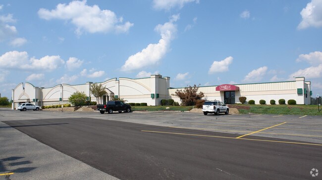
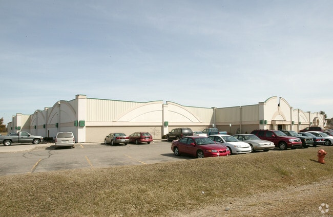
Property Record
4722 W Grand River Ave, Lansing, MI 48906
NEARBY LISTINGS FOR SALE OR LEASE
Property Detail
4722 W Grand River Ave
150-036-200-005-00
COM NW COR SEC 36 T5N R3W, TH N 89D 35M 23S E 579.06 FT, TO BEG, TH S 1694.01FT, TH N 89D 33M 26S E 723.63 FT, TH N 1693.62
Bowlingalley
Clinton
A
Michigan
26065C0013D
149.50 AC
2024
Outlying Clinton County
2025
West Michigan
010300
Lansing-East Lansing, MI
43,288 SF
DEMOGRAPHICS near 4722 W Grand River Ave
1 Mile
3 Mile
5 Mile
2024 Total Population
1,284
28,822
91,132
2029 Population
1,278
28,752
91,544
Pop Growth 2024-2029
(0.47%)
(0.24%)
+ 0.45%
Average Age
40
41
40
2024 Total Households
535
12,755
40,146
HH Growth 2024-2029
(0.56%)
(0.30%)
+ 0.38%
Median Household Inc
$76,882
$64,788
$61,592
Avg Household Size
2.40
2.20
2.20
2024 Avg HH Vehicles
2.00
2.00
2.00
Median Home Value
$287,951
$171,615
$169,450
Median Year Built
1972
1970
1968
Nearby Places
Map Layers
Map Styles
 Street
 Aerial
- Restaurants
- Banks
- Shops
- Fitness
- Groceries
PUBLIC TRANSPORTATION
AIRPORT
Capital Region International
DRIVE
WALK
Distance
Capital Region International
5 min
2.1 mi
Nearby Properties
Address
Land Use
TOTAL SIZE
Lot Size
Zoning
Address
Land Use
TOTAL SIZE
Lot Size
Zoning
2,137 SF
12.72 AC
H LT IN
Address
Land Use
TOTAL SIZE
Lot Size
Zoning
294,044 SF
30.86 AC
NONE
Address
Land Use
TOTAL SIZE
Lot Size
Zoning
436,698 SF
48.16 AC
NONE
Address
Land Use
TOTAL SIZE
Lot Size
Zoning
4,312 SF
30.47 AC
M3
Address
Land Use
TOTAL SIZE
Lot Size
Zoning
10,440 SF
18.30 AC
LI
Address
Land Use
TOTAL SIZE
Lot Size
Zoning
235,893 SF
18.69 AC
NONE
Address
Land Use
TOTAL SIZE
Lot Size
Zoning
73,485 SF
7.86 AC
LI
Address
Land Use
TOTAL SIZE
Lot Size
Zoning
189,157 SF
15.55 AC
NONE
Address
Land Use
TOTAL SIZE
Lot Size
Zoning
3,252 SF
10.16 AC
M3
Address
Land Use
TOTAL SIZE
Lot Size
Zoning
179,316 SF
16.68 AC
NONE
Address
Land Use
TOTAL SIZE
Lot Size
Zoning
155,772 SF
12.71 AC
NONE
Address
Land Use
TOTAL SIZE
Lot Size
Zoning
218,000 SF
15.60 AC
LI
Address
Land Use
TOTAL SIZE
Lot Size
Zoning
189,878 SF
27.62 AC
NONE
Address
Land Use
TOTAL SIZE
Lot Size
Zoning
125,060 SF
36.10 AC
LI
Address
Land Use
TOTAL SIZE
Lot Size
Zoning
200,072 SF
23.85 AC
NONE
Address
Land Use
TOTAL SIZE
Lot Size
Zoning
215,785 SF
14 AC
NONE
Address
Land Use
TOTAL SIZE
Lot Size
Zoning
131,649 SF
17.57 AC
NONE
Address
Land Use
TOTAL SIZE
Lot Size
Zoning
6,090 SF
12.96 AC
A RESID
Address
Land Use
TOTAL SIZE
Lot Size
Zoning
149,456 SF
14.49 AC
NONE
Address
Land Use
TOTAL SIZE
Lot Size
Zoning
130,671 SF
11.34 AC
NONE
Address
Land Use
TOTAL SIZE
Lot Size
Zoning
112,011 SF
12.12 AC
NONE
Address
Land Use
TOTAL SIZE
Lot Size
Zoning
142,400 SF
16.75 AC
LI
Address
Land Use
TOTAL SIZE
Lot Size
Zoning
88,550 SF
8.23 AC
NONE
Address
Land Use
TOTAL SIZE
Lot Size
Zoning
31,728 SF
5.92 AC
MIXED Z
Address
Land Use
TOTAL SIZE
Lot Size
Zoning
558,999 SF
41.65 AC
NONE
Address
Land Use
TOTAL SIZE
Lot Size
Zoning
149,770 SF
10.33 AC
NONE
Address
Land Use
TOTAL SIZE
Lot Size
Zoning
97,812 SF
12.16 AC
F COMME
Address
Land Use
TOTAL SIZE
Lot Size
Zoning
13,593 SF
20.95 AC
B-2
Address
Land Use
TOTAL SIZE
Lot Size
Zoning
210,000 SF
14.33 AC
LI
Address
Land Use
TOTAL SIZE
Lot Size
Zoning
48,750 SF
24.53 AC
LI
The World's #1 Commercial Real Estate Marketplace
Connect with us
© 2026 CoStar Group
The information above has been obtained from sources believed reliable. While we do not doubt its accuracy we have not verified it and make no guarantee, warranty or representation about it. It is your responsibility to independently confirm its accuracy and completeness. Any projections, opinions, assumptions, or estimates used are for example only and do not represent the current or future performance of the property. The value of this transaction to you depends on tax and other factors which should be evaluated by your tax, financial, and legal advisors. You and your advisors should conduct a careful, independent investigation of the property to determine to your satisfaction the suitability of the property for your needs.