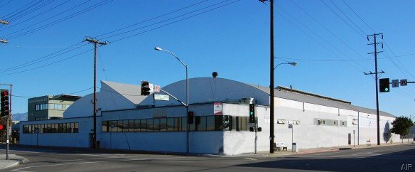
Property Record
4724 S Boyle Ave, Vernon, CA 90058
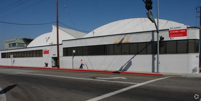

Current Lease Availabilities
NEARBY LISTINGS FOR SALE OR LEASE
Property Detail
4724 S Boyle Ave
Los Angeles-Long Beach-Glendale, CA
L A Fruitland Assoc 500 Ac Tr
6303-020-003
FIVE HUNDRED ACRE TRACT OF THE LOS ANGELES FRUIT LAND ASSOCIATION LOT ON N LINE OF LEONIS BLVD COM W THEREON 239 FT FROM E LINE OF LOT 19 TH W ON SD N LINE 66 FT WITH A UNIFORM DEPTH OF 184.8 FT N PART OF LOT 19
Parkinglot
Los Angeles
X
California
06037C1639F
19
2024
0.27 AC
2025
Vernon
980016
Los Angeles
10,840 SF
DEMOGRAPHICS near 4724 S Boyle Ave
1 Mile
3 Mile
5 Mile
2024 Total Population
6,405
296,908
969,613
2029 Population
6,089
280,832
926,576
Pop Growth 2024-2029
(4.93%)
(5.41%)
(4.44%)
Average Age
35
36
36
2024 Total Households
1,735
75,944
275,799
HH Growth 2024-2029
(5.24%)
(5.71%)
(4.29%)
Median Household Inc
$45,079
$52,597
$51,763
Avg Household Size
3.70
3.70
3.30
2024 Avg HH Vehicles
2.00
2.00
2.00
Median Home Value
$602,233
$568,454
$593,556
Median Year Built
1957
1950
1955
Nearby Places
Map Layers
Map Styles
 Street
 Aerial
- Restaurants
- Banks
- Shops
- Fitness
- Groceries
PUBLIC TRANSPORTATION
COMMUTER RAIL
Commerce (91 Line - Southern California Regional Rail Authority (Metrolink), Orange County Line - Southern California Regional Rail Authority (Metrolink))
DRIVE
WALK
Distance
Commerce (91 Line - Southern California Regional Rail Authority (Metrolink), Orange County Line - Southern California Regional Rail Authority (Metrolink))
11 min
5.2 mi
Union Station (91 Line - Southern California Regional Rail Authority (Metrolink), Antelope Valley Line - Southern California Regional Rail Authority (Metrolink), Orange County Line - Southern California Regional Rail Authority (Metrolink), Riverside Line - Southern California Regional Rail Authority (Metrolink), San Bernardino Line - Southern California Regional Rail Authority (Metrolink), Ventura County Line - Southern California Regional Rail Authority (Metrolink))
DRIVE
WALK
Distance
Union Station (91 Line - Southern California Regional Rail Authority (Metrolink), Antelope Valley Line - Southern California Regional Rail Authority (Metrolink), Orange County Line - Southern California Regional Rail Authority (Metrolink), Riverside Line - Southern California Regional Rail Authority (Metrolink), San Bernardino Line - Southern California Regional Rail Authority (Metrolink), Ventura County Line - Southern California Regional Rail Authority (Metrolink))
12 min
5.3 mi
AIRPORT
Los Angeles International
DRIVE
WALK
Distance
Los Angeles International
26 min
14.3 mi
Long Beach (Daugherty Field)
DRIVE
WALK
Distance
Long Beach (Daugherty Field)
27 min
16.9 mi
Bob Hope
DRIVE
WALK
Distance
Bob Hope
30 min
20.7 mi
Nearby Properties
Address
Land Use
TOTAL SIZE
Lot Size
Zoning
Address
Land Use
TOTAL SIZE
Lot Size
Zoning
2,697,158 SF
20.18 AC
LAM2
Address
Land Use
TOTAL SIZE
Lot Size
Zoning
444,139 SF
3.63 AC
LAM3
Address
Land Use
TOTAL SIZE
Lot Size
Zoning
479,272 SF
16.14 AC
LAM3
Address
Land Use
TOTAL SIZE
Lot Size
Zoning
1,088,170 SF
15.98 AC
LAM3
Address
Land Use
TOTAL SIZE
Lot Size
Zoning
327,061 SF
2.18 AC
LAM3
Address
Land Use
TOTAL SIZE
Lot Size
Zoning
182,700 SF
8.29 AC
LAM3
Address
Land Use
TOTAL SIZE
Lot Size
Zoning
693,282 SF
30.34 AC
CMM2*
Address
Land Use
TOTAL SIZE
Lot Size
Zoning
397,866 SF
3.51 AC
LAM3
Address
Land Use
TOTAL SIZE
Lot Size
Zoning
227,179 SF
10.46 AC
VEM*
Address
Land Use
TOTAL SIZE
Lot Size
Zoning
527,173 SF
12.36 AC
CMM2*
Address
Land Use
TOTAL SIZE
Lot Size
Zoning
326,472 SF
14.53 AC
VEM*
Address
Land Use
TOTAL SIZE
Lot Size
Zoning
188,319 SF
11.25 AC
VEM&MS1*
Address
Land Use
TOTAL SIZE
Lot Size
Zoning
108,598 SF
15.93 AC
LCC3*
Address
Land Use
TOTAL SIZE
Lot Size
Zoning
318,388 SF
11.07 AC
LAM2
Address
Land Use
TOTAL SIZE
Lot Size
Zoning
104,676 SF
4.32 AC
LAM3
Address
Land Use
TOTAL SIZE
Lot Size
Zoning
Address
Land Use
TOTAL SIZE
Lot Size
Zoning
279,682 SF
6.98 AC
VEM*
Address
Land Use
TOTAL SIZE
Lot Size
Zoning
251,338 SF
10.62 AC
LAM3
Address
Land Use
TOTAL SIZE
Lot Size
Zoning
841,076 SF
23.77 AC
CMM2*
Address
Land Use
TOTAL SIZE
Lot Size
Zoning
330,904 SF
12.09 AC
VEM*
Address
Land Use
TOTAL SIZE
Lot Size
Zoning
260,714 SF
9.99 AC
VEM*
Address
Land Use
TOTAL SIZE
Lot Size
Zoning
7.02 AC
LAM3
Address
Land Use
TOTAL SIZE
Lot Size
Zoning
116,728 SF
0.86 AC
HPCP*
Address
Land Use
TOTAL SIZE
Lot Size
Zoning
372,634 SF
10.83 AC
VEM*
Address
Land Use
TOTAL SIZE
Lot Size
Zoning
303,030 SF
7.14 AC
CMM2-M1*
Address
Land Use
TOTAL SIZE
Lot Size
Zoning
369,554 SF
8.49 AC
VEM*
Address
Land Use
TOTAL SIZE
Lot Size
Zoning
112,242 SF
1.64 AC
LAM3
Address
Land Use
TOTAL SIZE
Lot Size
Zoning
175,443 SF
7.18 AC
BLCM*
Address
Land Use
TOTAL SIZE
Lot Size
Zoning
234,264 SF
19.41 AC
LAM2
Address
Land Use
TOTAL SIZE
Lot Size
Zoning
261,540 SF
10.85 AC
VEM*
The World's #1 Commercial Real Estate Marketplace
Connect with us
© 2026 CoStar Group
The information above has been obtained from sources believed reliable. While we do not doubt its accuracy we have not verified it and make no guarantee, warranty or representation about it. It is your responsibility to independently confirm its accuracy and completeness. Any projections, opinions, assumptions, or estimates used are for example only and do not represent the current or future performance of the property. The value of this transaction to you depends on tax and other factors which should be evaluated by your tax, financial, and legal advisors. You and your advisors should conduct a careful, independent investigation of the property to determine to your satisfaction the suitability of the property for your needs.