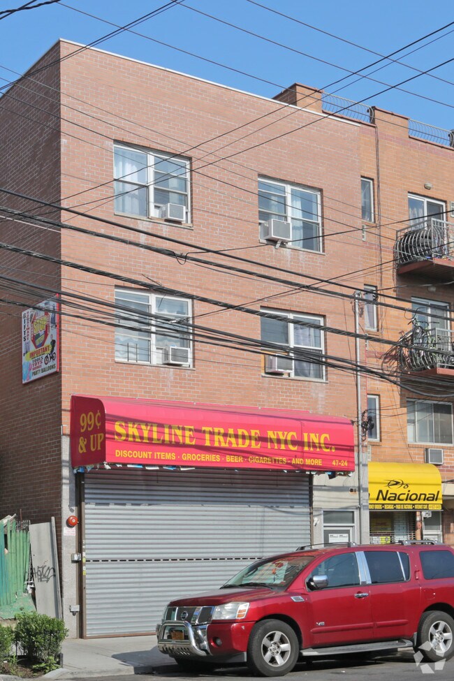
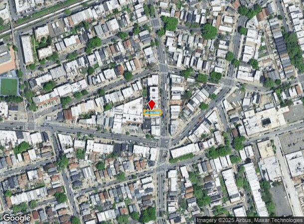
Property Record
4724 Junction Blvd, Corona, NY 11368

Property Detail
4724 Junction Blvd
01604-0046
Hitchcock 2Nd Plan Hms/People/
Commercialofficeresidentialmixeduse
Queens
X
New York
3604970226F
46
2024
0.06 AC
2025
Northeast Queens
046100
Long Island (New York)
3,309 SF
New York-Jersey City-White Plains, NY-NJ
NEARBY LISTINGS FOR SALE OR LEASE
DEMOGRAPHICS near 4724 Junction Blvd
1 mile
3 mile
5 mile
2024 Total Population
228,745
870,668
2,067,614
2029 Population
212,923
817,100
1,933,805
Pop Growth 2024-2029
(6.92%)
(6.15%)
(6.47%)
Average Age
40
42
40
2024 Total Households
70,949
311,370
765,088
HH Growth 2024-2029
(6.95%)
(6.24%)
(6.59%)
Median Household Inc
$61,595
$68,033
$74,233
Avg Household Size
3.10
2.70
2.60
2024 Avg HH Vehicles
1.00
1.00
1.00
Median Home Value
$565,935
$654,781
$723,552
Median Year Built
1956
1953
1952
Nearby Places
Map Layers
Map Styles
 Street
 Aerial
Transit
 Traffic
 Biking
Places
Listings with unknown addresses are not visible on the map
- Restaurants
- Banks
- Shops
- Fitness
- Groceries
PUBLIC TRANSPORTATION
TRANSIT/SUBWAY
Junction Boulevard (7 - New York MTA Subway (The Subway))
Drive
Walk
Distance
Junction Boulevard (7 - New York MTA Subway (The Subway))
1 min
10 min
0.5 mi
103 Street-Corona Plaza (7 - New York MTA Subway (The Subway))
Drive
Walk
Distance
103 Street-Corona Plaza (7 - New York MTA Subway (The Subway))
2 min
13 min
0.7 mi
Grand Avenue-Newtown (E - New York MTA Subway (The Subway), M - New York MTA Subway (The Subway), R - New York MTA Subway (The Subway))
Drive
Walk
Distance
Grand Avenue-Newtown (E - New York MTA Subway (The Subway), M - New York MTA Subway (The Subway), R - New York MTA Subway (The Subway))
2 min
15 min
0.8 mi
90 Street-Elmhurst Avenue (7 - New York MTA Subway (The Subway))
Drive
Walk
Distance
90 Street-Elmhurst Avenue (7 - New York MTA Subway (The Subway))
2 min
15 min
0.8 mi
Woodhaven Boulevard (E,G,R Line) (E - New York MTA Subway (The Subway), M - New York MTA Subway (The Subway), R - New York MTA Subway (The Subway))
Drive
Walk
Distance
Woodhaven Boulevard (E,G,R Line) (E - New York MTA Subway (The Subway), M - New York MTA Subway (The Subway), R - New York MTA Subway (The Subway))
3 min
16 min
0.8 mi
COMMUTER RAIL
Woodside Station (Babylon Branch - Long Island Rail Road, Far Rockaway Branch - Long Island Rail Road, Hempstead Branch - Long Island Rail Road, Long Beach Branch - Long Island Rail Road, Montauk Branch - Long Island Rail Road, Port Jefferson Branch - Long Island Rail Road, Port Washington Branch - Long Island Rail Road, Ronkonkoma Branch - Long Island Rail Road)
Drive
Walk
Distance
Woodside Station (Babylon Branch - Long Island Rail Road, Far Rockaway Branch - Long Island Rail Road, Hempstead Branch - Long Island Rail Road, Long Beach Branch - Long Island Rail Road, Montauk Branch - Long Island Rail Road, Port Jefferson Branch - Long Island Rail Road, Port Washington Branch - Long Island Rail Road, Ronkonkoma Branch - Long Island Rail Road)
5 min
2.2 mi
Forest Hills Station (Babylon Branch - Long Island Rail Road, Hempstead Branch - Long Island Rail Road, Long Beach Branch - Long Island Rail Road, Port Jefferson Branch - Long Island Rail Road)
Drive
Walk
Distance
Forest Hills Station (Babylon Branch - Long Island Rail Road, Hempstead Branch - Long Island Rail Road, Long Beach Branch - Long Island Rail Road, Port Jefferson Branch - Long Island Rail Road)
7 min
2.3 mi
AIRPORT
LaGuardia
Drive
Walk
Distance
LaGuardia
7 min
2.4 mi
John F Kennedy International
Drive
Walk
Distance
John F Kennedy International
15 min
10.3 mi
Newark Liberty International
Drive
Walk
Distance
Newark Liberty International
35 min
22.5 mi
Freight Ports
NY - Red Hook Container Terminal
Drive
Walk
Distance
NY - Red Hook Container Terminal
20 min
11.2 mi
SALE & LEASE HISTORY
LISTING DATE
SALE/LEASE

Sep 25, 2016
For Lease
Sep 23, 2016
For Sale
Nearby Properties
Address
Land Use
TOTAL SIZE
Lot Size
Zoning
Address
Land Use
TOTAL SIZE
Lot Size
Zoning
2,078,606 SF
58.93 AC
R4
Address
Land Use
TOTAL SIZE
Lot Size
Zoning
1,258,350 SF
410.24 AC
PARK
Address
Land Use
TOTAL SIZE
Lot Size
Zoning
1,502,532 SF
6.35 AC
R7B
Address
Land Use
TOTAL SIZE
Lot Size
Zoning
772,163 SF
5.24 AC
C4-5X
Address
Land Use
TOTAL SIZE
Lot Size
Zoning
54,170 SF
229.57 AC
PARK
Address
Land Use
TOTAL SIZE
Lot Size
Zoning
1,292,074 SF
C4-2F
Address
Land Use
TOTAL SIZE
Lot Size
Zoning
234,891 SF
3.17 AC
C4-5X
Address
Land Use
TOTAL SIZE
Lot Size
Zoning
1,516,458 SF
5.97 AC
R7-1
Address
Land Use
TOTAL SIZE
Lot Size
Zoning
8.28 AC
R7-1
Address
Land Use
TOTAL SIZE
Lot Size
Zoning
8.28 AC
R7-1
Address
Land Use
TOTAL SIZE
Lot Size
Zoning
8.28 AC
R7-1
Address
Land Use
TOTAL SIZE
Lot Size
Zoning
15,000 SF
255.27 AC
PARK
Address
Land Use
TOTAL SIZE
Lot Size
Zoning
126.85 AC
PARK
Address
Land Use
TOTAL SIZE
Lot Size
Zoning
743,160 SF
11.73 AC
R5
Address
Land Use
TOTAL SIZE
Lot Size
Zoning
743,160 SF
11.73 AC
R5
Address
Land Use
TOTAL SIZE
Lot Size
Zoning
743,160 SF
11.73 AC
R5
Address
Land Use
TOTAL SIZE
Lot Size
Zoning
743,160 SF
11.73 AC
R5
Address
Land Use
TOTAL SIZE
Lot Size
Zoning
743,160 SF
11.73 AC
R5
Address
Land Use
TOTAL SIZE
Lot Size
Zoning
743,160 SF
11.73 AC
R5
Address
Land Use
TOTAL SIZE
Lot Size
Zoning
743,160 SF
11.73 AC
R5
Address
Land Use
TOTAL SIZE
Lot Size
Zoning
743,160 SF
11.73 AC
R5
Address
Land Use
TOTAL SIZE
Lot Size
Zoning
743,160 SF
11.73 AC
R5
Address
Land Use
TOTAL SIZE
Lot Size
Zoning
743,160 SF
11.73 AC
R5
Address
Land Use
TOTAL SIZE
Lot Size
Zoning
743,160 SF
11.73 AC
R5
Address
Land Use
TOTAL SIZE
Lot Size
Zoning
743,160 SF
11.73 AC
R5
Address
Land Use
TOTAL SIZE
Lot Size
Zoning
743,160 SF
11.73 AC
R5
Address
Land Use
TOTAL SIZE
Lot Size
Zoning
743,160 SF
11.73 AC
R5
Address
Land Use
TOTAL SIZE
Lot Size
Zoning
743,160 SF
11.73 AC
R5
Address
Land Use
TOTAL SIZE
Lot Size
Zoning
743,160 SF
11.73 AC
R5
Address
Land Use
TOTAL SIZE
Lot Size
Zoning
743,160 SF
11.73 AC
R5
The World's #1 Commercial Real Estate Marketplace
Connect with us
© 2026 CoStar Group
The information above has been obtained from sources believed reliable. While we do not doubt its accuracy we have not verified it and make no guarantee, warranty or representation about it. It is your responsibility to independently confirm its accuracy and completeness. Any projections, opinions, assumptions, or estimates used are for example only and do not represent the current or future performance of the property. The value of this transaction to you depends on tax and other factors which should be evaluated by your tax, financial, and legal advisors. You and your advisors should conduct a careful, independent investigation of the property to determine to your satisfaction the suitability of the property for your needs.