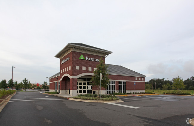
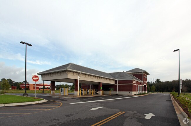
Property Record
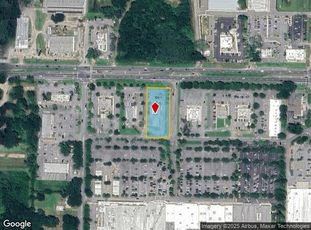
4725 Highway 90, Milton, FL 32571

NEARBY LISTINGS FOR SALE OR LEASE
Property Detail
4725 Highway 90
14-1N-29-0000-00207-0000
PARCEL C PER SURVEY PRVD: COM NE CORN OF NE4 OF NW4 SECTION 14 TOWNSHIP 1 NORTH RANGE 29 WEST THN S1*3844W 46.99 FT TO S R/W OF HWY 90 THN N88*480W 931. 69 FT THN S1*5018W 10 FT FOR POB THN S88*480E 152.50 FT THN S1*120W 327.19 FT THN N 88*480W 152.5
Financialbuilding
Santa Rosa
X
Florida
12113C0410H
1.15 AC
2024
Avalon Beach/Milton
2025
Pensacola
010704
Pensacola-Ferry Pass-Brent, FL
7,016 SF
DEMOGRAPHICS near 4725 Highway 90
1 mile
3 mile
5 mile
2024 Total Population
4,059
28,879
61,753
2029 Population
4,623
33,066
70,743
Pop Growth 2024-2029
+ 13.90%
+ 14.50%
+ 14.56%
Average Age
38
39
40
2024 Total Households
1,499
10,735
23,029
HH Growth 2024-2029
+ 14.14%
+ 14.81%
+ 14.87%
Median Household Inc
$69,497
$74,335
$79,318
Avg Household Size
2.70
2.70
2.70
2024 Avg HH Vehicles
2.00
2.00
2.00
Median Home Value
$217,758
$225,018
$247,885
Median Year Built
1994
1994
1995
Nearby Places
Map Layers
Map Styles
 Street
 Aerial
Transit
 Traffic
 Biking
Places
Listings with unknown addresses are not visible on the map
- Restaurants
- Banks
- Shops
- Fitness
- Groceries
PUBLIC TRANSPORTATION
AIRPORT
Pensacola International
Drive
Walk
Distance
Pensacola International
28 min
14.6 mi
Nearby Properties
Address
Land Use
TOTAL SIZE
Lot Size
Zoning
Address
Land Use
TOTAL SIZE
Lot Size
Zoning
374,114 SF
27.61 AC
R2
Address
Land Use
TOTAL SIZE
Lot Size
Zoning
118,887 SF
19.24 AC
HCD
Address
Land Use
TOTAL SIZE
Lot Size
Zoning
130,379 SF
18.18 AC
HCD
Address
Land Use
TOTAL SIZE
Lot Size
Zoning
79,708 SF
9.62 AC
HCD
Address
Land Use
TOTAL SIZE
Lot Size
Zoning
232,988 SF
24.57 AC
HCD
Address
Land Use
TOTAL SIZE
Lot Size
Zoning
154,042 SF
10.36 AC
HCD
Address
Land Use
TOTAL SIZE
Lot Size
Zoning
2,711 SF
342.27 AC
R1
Address
Land Use
TOTAL SIZE
Lot Size
Zoning
130,603 SF
14.30 AC
R2
Address
Land Use
TOTAL SIZE
Lot Size
Zoning
47.05 AC
AG-RR
Address
Land Use
TOTAL SIZE
Lot Size
Zoning
151,084 SF
19.01 AC
HCD
Address
Land Use
TOTAL SIZE
Lot Size
Zoning
78,019 SF
7 AC
R3
Address
Land Use
TOTAL SIZE
Lot Size
Zoning
199,775 SF
8.83 AC
HCD
Address
Land Use
TOTAL SIZE
Lot Size
Zoning
113,899 SF
3.05 AC
HCD
Address
Land Use
TOTAL SIZE
Lot Size
Zoning
81,123 SF
8.78 AC
HCD
Address
Land Use
TOTAL SIZE
Lot Size
Zoning
615,804 SF
16.46 AC
M2
Address
Land Use
TOTAL SIZE
Lot Size
Zoning
60,129 SF
0.11 AC
HCD
Address
Land Use
TOTAL SIZE
Lot Size
Zoning
81,150 SF
4.86 AC
HCD
Address
Land Use
TOTAL SIZE
Lot Size
Zoning
13.70 AC
HCD
Address
Land Use
TOTAL SIZE
Lot Size
Zoning
115,095 SF
7.44 AC
HCD
Address
Land Use
TOTAL SIZE
Lot Size
Zoning
76,674 SF
2.80 AC
HCD
Address
Land Use
TOTAL SIZE
Lot Size
Zoning
43,613 SF
3.44 AC
HCD
Address
Land Use
TOTAL SIZE
Lot Size
Zoning
389.54 AC
AG-RR
Address
Land Use
TOTAL SIZE
Lot Size
Zoning
9.61 AC
R1
Address
Land Use
TOTAL SIZE
Lot Size
Zoning
112,196 SF
343.01 AC
HCD
Address
Land Use
TOTAL SIZE
Lot Size
Zoning
37,820 SF
16.98 AC
HCD
Address
Land Use
TOTAL SIZE
Lot Size
Zoning
50,616 SF
2.56 AC
R3
Address
Land Use
TOTAL SIZE
Lot Size
Zoning
30,564 SF
11.12 AC
HCD
Address
Land Use
TOTAL SIZE
Lot Size
Zoning
51,760 SF
5.50 AC
HCD
Address
Land Use
TOTAL SIZE
Lot Size
Zoning
23,668 SF
2.30 AC
HCD
Address
Land Use
TOTAL SIZE
Lot Size
Zoning
49,275 SF
2.49 AC
HCD
The World's #1 Commercial Real Estate Marketplace
Connect with us
© 2026 CoStar Group
The information above has been obtained from sources believed reliable. While we do not doubt its accuracy we have not verified it and make no guarantee, warranty or representation about it. It is your responsibility to independently confirm its accuracy and completeness. Any projections, opinions, assumptions, or estimates used are for example only and do not represent the current or future performance of the property. The value of this transaction to you depends on tax and other factors which should be evaluated by your tax, financial, and legal advisors. You and your advisors should conduct a careful, independent investigation of the property to determine to your satisfaction the suitability of the property for your needs.