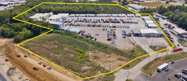
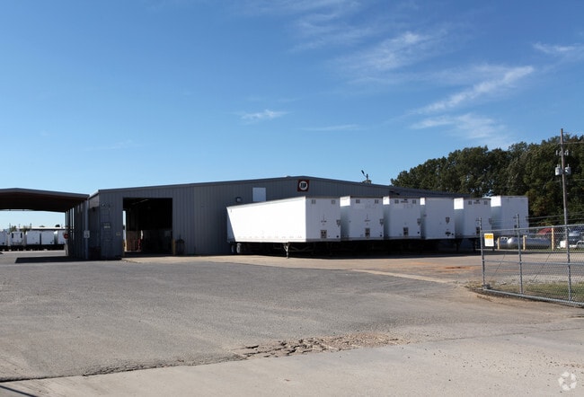
Property Record
Highway 78, Memphis, TN 38118
Current Lease Availabilities
NEARBY LISTINGS FOR SALE OR LEASE
Property Detail
Highway 78
09-4200-0-0387
260 FT SW OF HWY 78 SEE MAP 210K 260 FT SW OF HWY 78
Vacantlandnec
Shelby
AE
Tennessee
47157C0445F
7.80 AC
2024
Southeast
2025
Memphis
022600
Memphis, TN-MS-AR
DEMOGRAPHICS near Highway 78
1 Mile
3 Mile
5 Mile
2024 Total Population
5
39,119
153,218
2029 Population
5
39,142
154,192
Pop Growth 2024-2029
0.00%
+ 0.06%
+ 0.64%
Average Age
0
34
36
2024 Total Households
2
13,324
56,454
HH Growth 2024-2029
0.00%
+ 0.04%
+ 0.65%
Median Household Inc
$0
$44,179
$50,018
Avg Household Size
.00
2.90
2.70
2024 Avg HH Vehicles
1.00
2.00
2.00
Median Home Value
$0
$151,092
$173,082
Median Year Built
1979
1977
1980
Nearby Places
Map Layers
Map Styles
 Street
 Aerial
- Restaurants
- Banks
- Shops
- Fitness
- Groceries
PUBLIC TRANSPORTATION
AIRPORT
Memphis International
DRIVE
WALK
Distance
Memphis International
11 min
7.4 mi
Freight Ports
Port of Shreveport
DRIVE
WALK
Distance
Port of Shreveport
416 min
381.2 mi
Nearby Properties
Address
Land Use
TOTAL SIZE
Lot Size
Zoning
Address
Land Use
TOTAL SIZE
Lot Size
Zoning
969,150 SF
64.49 AC
EMP
Address
Land Use
TOTAL SIZE
Lot Size
Zoning
863,591 SF
35.66 AC
EMP
Address
Land Use
TOTAL SIZE
Lot Size
Zoning
897,076 SF
47.33 AC
CA
Address
Land Use
TOTAL SIZE
Lot Size
Zoning
921,576 SF
25.20 AC
CA
Address
Land Use
TOTAL SIZE
Lot Size
Zoning
865,065 SF
51.05 AC
CA
Address
Land Use
TOTAL SIZE
Lot Size
Zoning
834,463 SF
37.46 AC
EMP
Address
Land Use
TOTAL SIZE
Lot Size
Zoning
794,452 SF
39.72 AC
EMP
Address
Land Use
TOTAL SIZE
Lot Size
Zoning
838,318 SF
39.56 AC
I-L
Address
Land Use
TOTAL SIZE
Lot Size
Zoning
704,564 SF
28.30 AC
EMP
Address
Land Use
TOTAL SIZE
Lot Size
Zoning
1,403,383 SF
93.69 AC
IH
Address
Land Use
TOTAL SIZE
Lot Size
Zoning
237,911 SF
21.38 AC
EMP
Address
Land Use
TOTAL SIZE
Lot Size
Zoning
498,764 SF
22.57 AC
CA
Address
Land Use
TOTAL SIZE
Lot Size
Zoning
571,642 SF
23.56 AC
EMP
Address
Land Use
TOTAL SIZE
Lot Size
Zoning
1,292,907 SF
83.13 AC
IH
Address
Land Use
TOTAL SIZE
Lot Size
Zoning
461,807 SF
28.93 AC
EMP
Address
Land Use
TOTAL SIZE
Lot Size
Zoning
434,122 SF
23.97 AC
R-6
Address
Land Use
TOTAL SIZE
Lot Size
Zoning
1,034,433 SF
53.32 AC
EMP
Address
Land Use
TOTAL SIZE
Lot Size
Zoning
861,322 SF
72.92 AC
CA
Address
Land Use
TOTAL SIZE
Lot Size
Zoning
419,065 SF
19.92 AC
EMP
Address
Land Use
TOTAL SIZE
Lot Size
Zoning
1,155,303 SF
61.73 AC
IH
Address
Land Use
TOTAL SIZE
Lot Size
Zoning
158,366 SF
24.31 AC
R-6
Address
Land Use
TOTAL SIZE
Lot Size
Zoning
16,432 SF
445 AC
EMP
Address
Land Use
TOTAL SIZE
Lot Size
Zoning
326,743 SF
22.91 AC
R-8
Address
Land Use
TOTAL SIZE
Lot Size
Zoning
345,770 SF
18.13 AC
EMP
Address
Land Use
TOTAL SIZE
Lot Size
Zoning
903,083 SF
45.12 AC
EMP
Address
Land Use
TOTAL SIZE
Lot Size
Zoning
350,298 SF
12.68 AC
EMP
Address
Land Use
TOTAL SIZE
Lot Size
Zoning
739,205 SF
31.51 AC
AG
Address
Land Use
TOTAL SIZE
Lot Size
Zoning
330,758 SF
12.09 AC
EMP
Address
Land Use
TOTAL SIZE
Lot Size
Zoning
654,400 SF
46.39 AC
EMP
Address
Land Use
TOTAL SIZE
Lot Size
Zoning
715,375 SF
37.51 AC
EMP
The World's #1 Commercial Real Estate Marketplace
Connect with us
© 2026 CoStar Group
The information above has been obtained from sources believed reliable. While we do not doubt its accuracy we have not verified it and make no guarantee, warranty or representation about it. It is your responsibility to independently confirm its accuracy and completeness. Any projections, opinions, assumptions, or estimates used are for example only and do not represent the current or future performance of the property. The value of this transaction to you depends on tax and other factors which should be evaluated by your tax, financial, and legal advisors. You and your advisors should conduct a careful, independent investigation of the property to determine to your satisfaction the suitability of the property for your needs.