Property Record
4728 Sandy Camp Rd, High Point, NC 27265
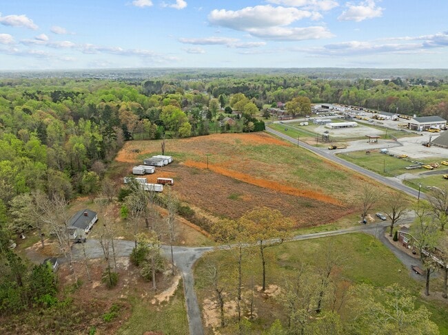

Property Detail
4728 Sandy Camp Rd
Greensboro-High Point, NC
11.10AC GRAY
0170941
GUILFORD
Agriculturalland
North Carolina
AG
65
B and X Area of moderate flood hazard, usually the area between the limits of the 100-year and 500-year floods.
11.10 AC
2024
Airport/W Guilford County
2025
Greensboro/Winston-Salem
016204
NEARBY LISTINGS FOR SALE OR LEASE
DEMOGRAPHICS near 4728 Sandy Camp Rd
1 mile
3 mile
5 mile
2025 Total Population
2,683
20,627
66,438
2030 Population
2,822
21,444
68,778
Pop Growth 2025-2030
+ 5.18%
+ 3.96%
+ 3.52%
Average Age
43
41
42
2025 Total Households
1,014
7,807
28,062
HH Growth 2025-2030
+ 5.52%
+ 4.15%
+ 3.68%
Median Household Inc
$108,620
$104,267
$80,627
Avg Household Size
2.60
2.60
2.30
2025 Avg HH Vehicles
2.00
2.00
2.00
Median Home Value
$353,278
$323,163
$289,475
Median Year Built
2007
2001
1997
Nearby Places
Map Layers
Map Styles
 Street
 Aerial
Transit
 Traffic
 Biking
Places
Listings with unknown addresses are not visible on the map
- Restaurants
- Banks
- Shops
- Fitness
- Groceries
PUBLIC TRANSPORTATION
COMMUTER RAIL
High Point Station (Piedmont - North Carolina by Train (NC Train))
Drive
Walk
Distance
High Point Station (Piedmont - North Carolina by Train (NC Train))
18 min
9.5 mi
AIRPORT
Piedmont Triad International
Drive
Walk
Distance
Piedmont Triad International
19 min
7.6 mi
Nearby Properties
Address
Land Use
TOTAL SIZE
Lot Size
Zoning
Address
Land Use
TOTAL SIZE
Lot Size
Zoning
274,486 SF
30.31 AC
MBP
Address
Land Use
TOTAL SIZE
Lot Size
Zoning
1,001,670 SF
94.34 AC
BI
Address
Land Use
TOTAL SIZE
Lot Size
Zoning
37,237 SF
334.45 AC
HI
Address
Land Use
TOTAL SIZE
Lot Size
Zoning
1,057,283 SF
104.31 AC
PDP
Address
Land Use
TOTAL SIZE
Lot Size
Zoning
256,051 SF
37.69 AC
LI
Address
Land Use
TOTAL SIZE
Lot Size
Zoning
181,444 SF
126.42 AC
PD-P
Address
Land Use
TOTAL SIZE
Lot Size
Zoning
667,440 SF
53.44 AC
BI
Address
Land Use
TOTAL SIZE
Lot Size
Zoning
691,408 SF
58.69 AC
LI
Address
Land Use
TOTAL SIZE
Lot Size
Zoning
186,200 SF
10.58 AC
LI
Address
Land Use
TOTAL SIZE
Lot Size
Zoning
342,765 SF
20.98 AC
PUD
Address
Land Use
TOTAL SIZE
Lot Size
Zoning
509,216 SF
40.85 AC
LI
Address
Land Use
TOTAL SIZE
Lot Size
Zoning
400,000 SF
46.72 AC
LI
Address
Land Use
TOTAL SIZE
Lot Size
Zoning
229,103 SF
18.76 AC
CZ-I
Address
Land Use
TOTAL SIZE
Lot Size
Zoning
309,749 SF
16.74 AC
CZ-PDM
Address
Land Use
TOTAL SIZE
Lot Size
Zoning
428,867 SF
76.65 AC
LI
Address
Land Use
TOTAL SIZE
Lot Size
Zoning
362,708 SF
56.81 AC
LI
Address
Land Use
TOTAL SIZE
Lot Size
Zoning
254,290 SF
21.12 AC
RM-12
Address
Land Use
TOTAL SIZE
Lot Size
Zoning
299,786 SF
24.49 AC
PDP
Address
Land Use
TOTAL SIZE
Lot Size
Zoning
227,652 SF
21.64 AC
LI
Address
Land Use
TOTAL SIZE
Lot Size
Zoning
275,040 SF
28 AC
BI
Address
Land Use
TOTAL SIZE
Lot Size
Zoning
161,975 SF
20.66 AC
BP
Address
Land Use
TOTAL SIZE
Lot Size
Zoning
75,588 SF
6.49 AC
LI
Address
Land Use
TOTAL SIZE
Lot Size
Zoning
176,000 SF
12.95 AC
CZ-I
Address
Land Use
TOTAL SIZE
Lot Size
Zoning
361,412 SF
35.81 AC
LI
Address
Land Use
TOTAL SIZE
Lot Size
Zoning
311,785 SF
107.44 AC
PI
Address
Land Use
TOTAL SIZE
Lot Size
Zoning
66,780 SF
16.64 AC
LI
Address
Land Use
TOTAL SIZE
Lot Size
Zoning
233,893 SF
51.31 AC
LI
Address
Land Use
TOTAL SIZE
Lot Size
Zoning
99,998 SF
12.44 AC
LI
Address
Land Use
TOTAL SIZE
Lot Size
Zoning
266,881 SF
29.68 AC
AG
Address
Land Use
TOTAL SIZE
Lot Size
Zoning
171,955 SF
6.16 AC
BP
The World's #1 Commercial Real Estate Marketplace
Connect with us
© 2026 CoStar Group
The information above has been obtained from sources believed reliable. While we do not doubt its accuracy we have not verified it and make no guarantee, warranty or representation about it. It is your responsibility to independently confirm its accuracy and completeness. Any projections, opinions, assumptions, or estimates used are for example only and do not represent the current or future performance of the property. The value of this transaction to you depends on tax and other factors which should be evaluated by your tax, financial, and legal advisors. You and your advisors should conduct a careful, independent investigation of the property to determine to your satisfaction the suitability of the property for your needs.