Property Record
365 County Road 4971, Blue Ridge, TX 75424
Property Detail
365 County Road 4971
77094
A0553 H C HURST, ACRES 11.0, LABEL# PFS0583365
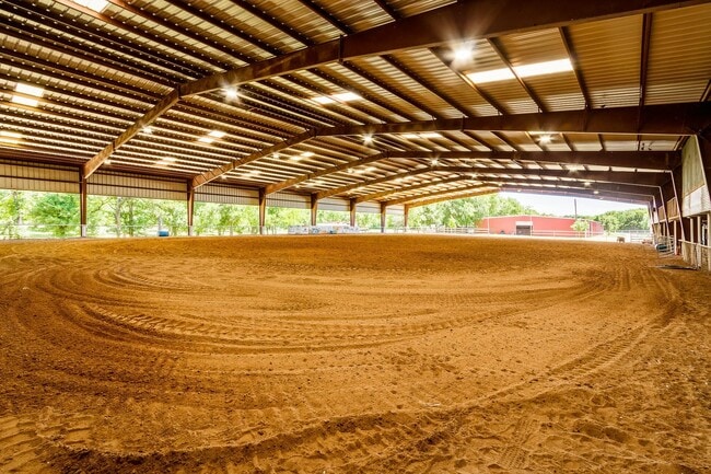
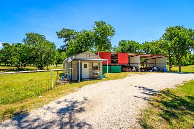
Farms
Fannin
A Areas with a 1% annual chance of flooding and a 26% chance of flooding over the life of a 30-year mortgage.
Texas
2025
18.69 AC
2025
Texas North Area
030102
Other Market Areas
28,960 SF
Bonham, TX
NEARBY LISTINGS FOR SALE OR LEASE
-
-
View all Blue Ridge listings for sale on LoopNet.com
DEMOGRAPHICS near 365 County Road 4971
1 mile
3 mile
5 mile
2025 Total Population
199
2,100
6,758
2030 Population
216
2,275
7,354
Pop Growth 2025-2030
+ 8.54%
+ 8.33%
+ 8.82%
Average Age
40
40
41
2025 Total Households
68
737
2,415
HH Growth 2025-2030
+ 8.82%
+ 8.68%
+ 9.03%
Median Household Inc
$96,874
$91,176
$89,638
Avg Household Size
2.80
2.80
2.70
2025 Avg HH Vehicles
2.00
2.00
2.00
Median Home Value
$416,667
$377,868
$373,610
Median Year Built
2004
2002
2000
Nearby Places
Map Layers
Map Styles
 Street
 Aerial
Layers
 Traffic
 Biking
Places
Listings with unknown addresses are not visible on the map
- Restaurants
- Banks
- Shops
- Fitness
- Groceries
SALE & LEASE HISTORY
LISTING DATE
SALE/LEASE

Nov 01, 2023
For Sale
Nearby Properties
Address
Land Use
TOTAL SIZE
Lot Size
Zoning
Address
Land Use
TOTAL SIZE
Lot Size
Zoning
278,814 SF
59.01 AC
Address
Land Use
TOTAL SIZE
Lot Size
Zoning
167.26 AC
Address
Land Use
TOTAL SIZE
Lot Size
Zoning
10,854 SF
78.45 AC
Address
Land Use
TOTAL SIZE
Lot Size
Zoning
6,900 SF
76.47 AC
Address
Land Use
TOTAL SIZE
Lot Size
Zoning
Address
Land Use
TOTAL SIZE
Lot Size
Zoning
8,171 SF
73.51 AC
Address
Land Use
TOTAL SIZE
Lot Size
Zoning
168.41 AC
Address
Land Use
TOTAL SIZE
Lot Size
Zoning
Address
Land Use
TOTAL SIZE
Lot Size
Zoning
36,225 SF
28.79 AC
Address
Land Use
TOTAL SIZE
Lot Size
Zoning
1,040 SF
48.64 AC
Address
Land Use
TOTAL SIZE
Lot Size
Zoning
155 AC
Address
Land Use
TOTAL SIZE
Lot Size
Zoning
45.39 AC
Address
Land Use
TOTAL SIZE
Lot Size
Zoning
13,680 SF
4.99 AC
Address
Land Use
TOTAL SIZE
Lot Size
Zoning
24.16 AC
Address
Land Use
TOTAL SIZE
Lot Size
Zoning
48.32 AC
Address
Land Use
TOTAL SIZE
Lot Size
Zoning
5,927 SF
13.12 AC
Address
Land Use
TOTAL SIZE
Lot Size
Zoning
8,827 SF
90.83 AC
Address
Land Use
TOTAL SIZE
Lot Size
Zoning
21.60 AC
Address
Land Use
TOTAL SIZE
Lot Size
Zoning
2,514 SF
105.39 AC
Address
Land Use
TOTAL SIZE
Lot Size
Zoning
24.77 AC
Address
Land Use
TOTAL SIZE
Lot Size
Zoning
9,134 SF
2 AC
Address
Land Use
TOTAL SIZE
Lot Size
Zoning
14,400 SF
8.93 AC
Address
Land Use
TOTAL SIZE
Lot Size
Zoning
8,650 SF
5 AC
Address
Land Use
TOTAL SIZE
Lot Size
Zoning
160 AC
Address
Land Use
TOTAL SIZE
Lot Size
Zoning
115.82 AC
Address
Land Use
TOTAL SIZE
Lot Size
Zoning
160 AC
Address
Land Use
TOTAL SIZE
Lot Size
Zoning
1 AC
Address
Land Use
TOTAL SIZE
Lot Size
Zoning
2,759 SF
9.14 AC
Address
Land Use
TOTAL SIZE
Lot Size
Zoning
5,000 SF
22.74 AC
The World's #1 Commercial Real Estate Marketplace
Connect with us
© 2026 CoStar Group
The information above has been obtained from sources believed reliable. While we do not doubt its accuracy we have not verified it and make no guarantee, warranty or representation about it. It is your responsibility to independently confirm its accuracy and completeness. Any projections, opinions, assumptions, or estimates used are for example only and do not represent the current or future performance of the property. The value of this transaction to you depends on tax and other factors which should be evaluated by your tax, financial, and legal advisors. You and your advisors should conduct a careful, independent investigation of the property to determine to your satisfaction the suitability of the property for your needs.