Property Record
473 Highway 29 N, Athens, GA 30601
NEARBY LISTINGS FOR SALE OR LEASE
-
-
View all Athens listings for sale on LoopNet.com
Property Detail
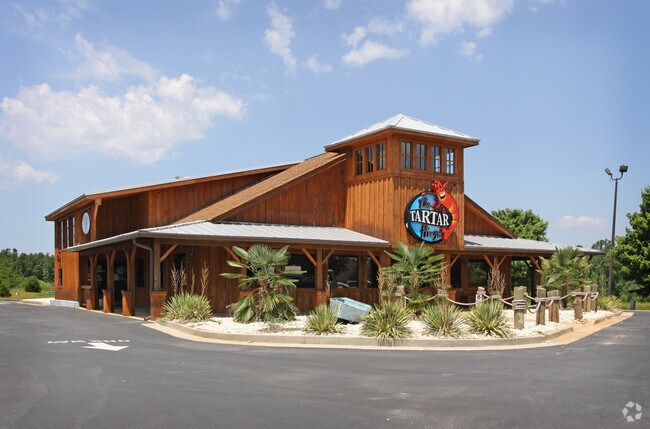
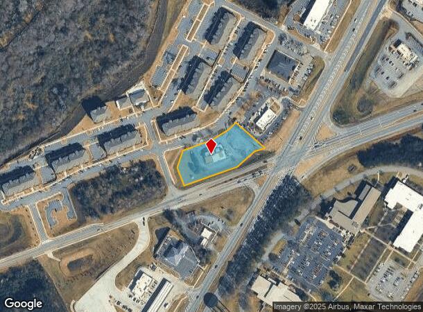
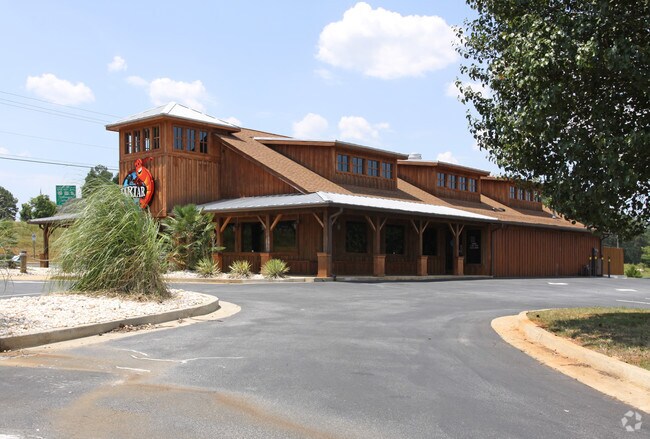
473 Highway 29 N
Athens-Clarke County, GA
Com-St-074
154-038-J
LOT: TR B; DEEDED ACS: 1.439
Restaurantbuilding
Clarke
X
Georgia
13059C0017F
tr
2025
1.44 AC
2025
North Athens
140400
Other Market Areas
4,744 SF
DEMOGRAPHICS near 473 Highway 29 N
1 Mile
3 Mile
5 Mile
2024 Total Population
932
23,500
81,621
2029 Population
966
23,630
82,614
Pop Growth 2024-2029
+ 3.65%
+ 0.55%
+ 1.22%
Average Age
39
35
33
2024 Total Households
352
9,139
31,011
HH Growth 2024-2029
+ 3.98%
+ 0.40%
+ 1.15%
Median Household Inc
$60,882
$38,234
$44,990
Avg Household Size
2.60
2.50
2.30
2024 Avg HH Vehicles
2.00
2.00
2.00
Median Home Value
$95,934
$140,990
$207,467
Median Year Built
1996
1991
1983
Nearby Places
Map Layers
Map Styles
 Street
 Aerial
- Restaurants
- Banks
- Shops
- Fitness
- Groceries
SALE & LEASE HISTORY
LISTING DATE
SALE/LEASE

Jul 28, 2020
For Sale
Nearby Properties
Address
Land Use
TOTAL SIZE
Lot Size
Zoning
Address
Land Use
TOTAL SIZE
Lot Size
Zoning
10,240 SF
6.47 AC
G
Address
Land Use
TOTAL SIZE
Lot Size
Zoning
213,612 SF
3.07 AC
C-D
Address
Land Use
TOTAL SIZE
Lot Size
Zoning
226,339 SF
2.32 AC
C-D (RIV)
Address
Land Use
TOTAL SIZE
Lot Size
Zoning
1,403 SF
21.64 AC
C-G
Address
Land Use
TOTAL SIZE
Lot Size
Zoning
3.16 AC
E-I
Address
Land Use
TOTAL SIZE
Lot Size
Zoning
265,400 SF
2.95 AC
C-D
Address
Land Use
TOTAL SIZE
Lot Size
Zoning
2,856 SF
39.78 AC
C-G
Address
Land Use
TOTAL SIZE
Lot Size
Zoning
15.29 AC
G
Address
Land Use
TOTAL SIZE
Lot Size
Zoning
8,357 SF
22.38 AC
RM-2
Address
Land Use
TOTAL SIZE
Lot Size
Zoning
125,888 SF
1.11 AC
C-D
Address
Land Use
TOTAL SIZE
Lot Size
Zoning
42,152 SF
4.01 AC
G
Address
Land Use
TOTAL SIZE
Lot Size
Zoning
4.06 AC
G
Address
Land Use
TOTAL SIZE
Lot Size
Zoning
124,959 SF
20.54 AC
E-I
Address
Land Use
TOTAL SIZE
Lot Size
Zoning
88,250 SF
3.09 AC
C-D
Address
Land Use
TOTAL SIZE
Lot Size
Zoning
83,755 SF
1.70 AC
C-D
Address
Land Use
TOTAL SIZE
Lot Size
Zoning
95,561 SF
1.02 AC
C-D (RIV)
Address
Land Use
TOTAL SIZE
Lot Size
Zoning
2,880 SF
36.84 AC
RM-1
Address
Land Use
TOTAL SIZE
Lot Size
Zoning
65,817 SF
4.45 AC
G
Address
Land Use
TOTAL SIZE
Lot Size
Zoning
3,628 SF
6.57 AC
RM-2
Address
Land Use
TOTAL SIZE
Lot Size
Zoning
140,375 SF
26.15 AC
E-I
Address
Land Use
TOTAL SIZE
Lot Size
Zoning
13,224 SF
3.80 AC
C-D
Address
Land Use
TOTAL SIZE
Lot Size
Zoning
46.26 AC
G
Address
Land Use
TOTAL SIZE
Lot Size
Zoning
Address
Land Use
TOTAL SIZE
Lot Size
Zoning
9,600 SF
12.71 AC
RM-2
Address
Land Use
TOTAL SIZE
Lot Size
Zoning
14,000 SF
42.62 AC
E-I
Address
Land Use
TOTAL SIZE
Lot Size
Zoning
4,392 SF
11.79 AC
C-G
Address
Land Use
TOTAL SIZE
Lot Size
Zoning
26,100 SF
18.59 AC
C-G
Address
Land Use
TOTAL SIZE
Lot Size
Zoning
51,184 SF
1.11 AC
C-D
Address
Land Use
TOTAL SIZE
Lot Size
Zoning
12.87 AC
P
Address
Land Use
TOTAL SIZE
Lot Size
Zoning
20.74 AC
G
The World's #1 Commercial Real Estate Marketplace
Connect with us
© 2025 CoStar Group
The information above has been obtained from sources believed reliable. While we do not doubt its accuracy we have not verified it and make no guarantee, warranty or representation about it. It is your responsibility to independently confirm its accuracy and completeness. Any projections, opinions, assumptions, or estimates used are for example only and do not represent the current or future performance of the property. The value of this transaction to you depends on tax and other factors which should be evaluated by your tax, financial, and legal advisors. You and your advisors should conduct a careful, independent investigation of the property to determine to your satisfaction the suitability of the property for your needs.