Property Record
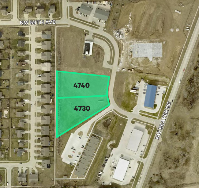
4730 Nw 59Th Ave, Johnston, IA 50131

This Property Is For Sale
NEARBY LISTINGS FOR SALE OR LEASE
Property Detail
4730 Nw 59Th Ave
Des Moines-West Des Moines, IA
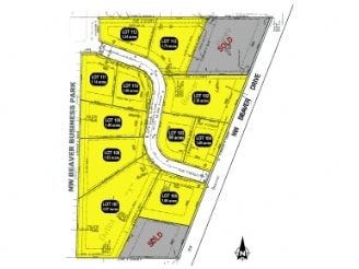
Nw Beaver Business Park
241-00847400008
LOT 108 NW BEAVER BUSINESS PARK
Agriculturalland
Polk
X
Iowa
19153C0195F
108
2024
1.82 AC
2025
Western Suburbs
011702
Des Moines
DEMOGRAPHICS near 4730 Nw 59Th Ave
1 Mile
3 Mile
5 Mile
2024 Total Population
4,702
39,609
152,445
2029 Population
4,929
40,912
158,165
Pop Growth 2024-2029
+ 4.83%
+ 3.29%
+ 3.75%
Average Age
41
39
38
2024 Total Households
2,045
15,910
60,435
HH Growth 2024-2029
+ 5.18%
+ 3.55%
+ 3.89%
Median Household Inc
$74,904
$79,376
$75,887
Avg Household Size
2.20
2.40
2.40
2024 Avg HH Vehicles
2.00
2.00
2.00
Median Home Value
$256,328
$237,659
$228,999
Median Year Built
1998
1981
1975
Nearby Places
- Restaurants
- Banks
- Shops
- Fitness
- Groceries
PUBLIC TRANSPORTATION
AIRPORT
Des Moines International
DRIVE
WALK
Distance
Des Moines International
23 min
11.4 mi
Nearby Properties
Address
Land Use
TOTAL SIZE
Lot Size
Zoning
Address
Land Use
TOTAL SIZE
Lot Size
Zoning
486,792 SF
38.70 AC
PC
Address
Land Use
TOTAL SIZE
Lot Size
Zoning
627,104 SF
40.09 AC
Address
Land Use
TOTAL SIZE
Lot Size
Zoning
197,658 SF
15.91 AC
Address
Land Use
TOTAL SIZE
Lot Size
Zoning
184,658 SF
14.61 AC
Address
Land Use
TOTAL SIZE
Lot Size
Zoning
166,160 SF
11.88 AC
Address
Land Use
TOTAL SIZE
Lot Size
Zoning
287,228 SF
27.32 AC
A-R
Address
Land Use
TOTAL SIZE
Lot Size
Zoning
307,734 SF
23.59 AC
R-3
Address
Land Use
TOTAL SIZE
Lot Size
Zoning
71,938 SF
8.23 AC
C-O
Address
Land Use
TOTAL SIZE
Lot Size
Zoning
101,592 SF
7.79 AC
PUD
Address
Land Use
TOTAL SIZE
Lot Size
Zoning
386,236 SF
9.62 AC
C-4
Address
Land Use
TOTAL SIZE
Lot Size
Zoning
141,377 SF
3.16 AC
Address
Land Use
TOTAL SIZE
Lot Size
Zoning
363,736 SF
25.79 AC
M-1
Address
Land Use
TOTAL SIZE
Lot Size
Zoning
188,453 SF
14.20 AC
R-3
Address
Land Use
TOTAL SIZE
Lot Size
Zoning
146,025 SF
9.59 AC
PUD
Address
Land Use
TOTAL SIZE
Lot Size
Zoning
223,876 SF
15.01 AC
Address
Land Use
TOTAL SIZE
Lot Size
Zoning
143,831 SF
16.12 AC
PUD
Address
Land Use
TOTAL SIZE
Lot Size
Zoning
95,039 SF
4.52 AC
PUD
Address
Land Use
TOTAL SIZE
Lot Size
Zoning
56,478 SF
5.86 AC
Address
Land Use
TOTAL SIZE
Lot Size
Zoning
158,256 SF
8.87 AC
R-3
Address
Land Use
TOTAL SIZE
Lot Size
Zoning
130,686 SF
1.23 AC
Address
Land Use
TOTAL SIZE
Lot Size
Zoning
203,062 SF
17.82 AC
C-2
Address
Land Use
TOTAL SIZE
Lot Size
Zoning
92,392 SF
12.40 AC
C-2
Address
Land Use
TOTAL SIZE
Lot Size
Zoning
63,201 SF
3.67 AC
Address
Land Use
TOTAL SIZE
Lot Size
Zoning
140,163 SF
5.87 AC
PUD
Address
Land Use
TOTAL SIZE
Lot Size
Zoning
114,048 SF
8.64 AC
PUD
Address
Land Use
TOTAL SIZE
Lot Size
Zoning
95,400 SF
4.40 AC
PUD
Address
Land Use
TOTAL SIZE
Lot Size
Zoning
53,827 SF
5.72 AC
Address
Land Use
TOTAL SIZE
Lot Size
Zoning
292,167 SF
9.53 AC
C-4
Address
Land Use
TOTAL SIZE
Lot Size
Zoning
80,559 SF
4.50 AC
Address
Land Use
TOTAL SIZE
Lot Size
Zoning
62,183 SF
3.41 AC
R-1S
The World's #1 Commercial Real Estate Marketplace
Connect with us
© 2025 CoStar Group
The information above has been obtained from sources believed reliable. While we do not doubt its accuracy we have not verified it and make no guarantee, warranty or representation about it. It is your responsibility to independently confirm its accuracy and completeness. Any projections, opinions, assumptions, or estimates used are for example only and do not represent the current or future performance of the property. The value of this transaction to you depends on tax and other factors which should be evaluated by your tax, financial, and legal advisors. You and your advisors should conduct a careful, independent investigation of the property to determine to your satisfaction the suitability of the property for your needs.