Property Record
4730 Scruggs Rd, Moneta, VA 24121
NEARBY LISTINGS FOR SALE OR LEASE
-
-
View all Moneta listings for sale on LoopNet.com
Property Detail
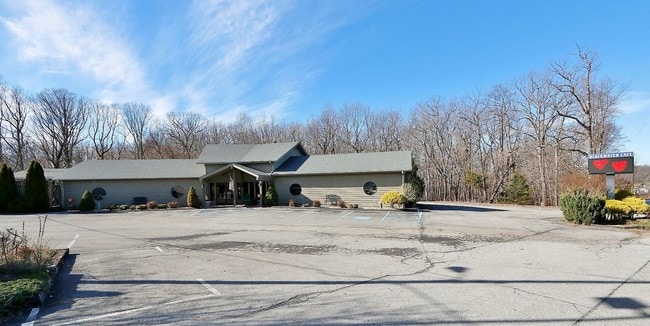
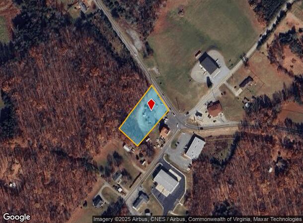
4730 Scruggs Rd
0320002201
Blackwater
Restaurantbuilding
RT 616-SCRUGGS ROAD BLACKWATER CAFE
X
Franklin
51019C0535D
Virginia
2025
1.24 AC
2025
North Franklin County
020104
Roanoke
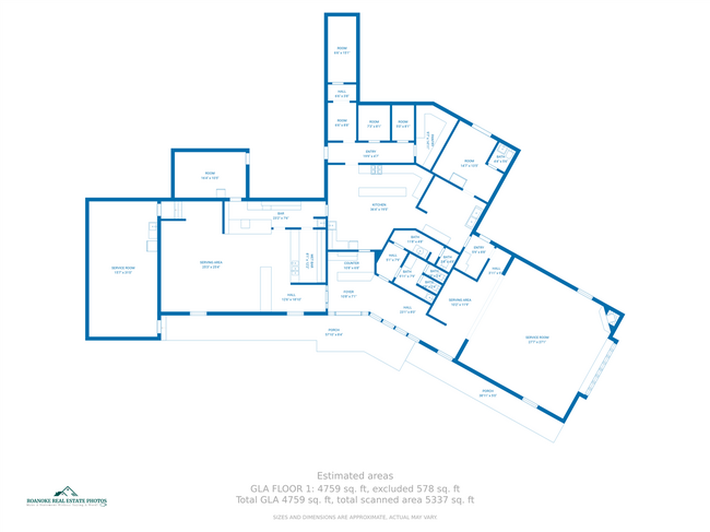
4,183 SF
Roanoke, VA
DEMOGRAPHICS near 4730 Scruggs Rd
1 Mile
3 Mile
5 Mile
2024 Total Population
311
6,227
13,175
2029 Population
332
6,690
14,193
Pop Growth 2024-2029
+ 6.75%
+ 7.44%
+ 7.73%
Average Age
53
55
54
2024 Total Households
141
2,908
6,112
HH Growth 2024-2029
+ 6.38%
+ 7.43%
+ 7.74%
Median Household Inc
$95,088
$93,809
$87,324
Avg Household Size
2.10
2.10
2.10
2024 Avg HH Vehicles
2.00
2.00
2.00
Median Home Value
$460,714
$495,399
$510,150
Median Year Built
1994
1990
1991
Nearby Places
Map Layers
Map Styles
 Street
 Aerial
- Restaurants
- Banks
- Shops
- Fitness
- Groceries
PUBLIC TRANSPORTATION
AIRPORT
Roanoke/Blacksburg Regional (Woodrum Field)
DRIVE
WALK
Distance
Roanoke/Blacksburg Regional (Woodrum Field)
51 min
32.6 mi
Lynchburg Regional/Preston Glenn Field
DRIVE
WALK
Distance
Lynchburg Regional/Preston Glenn Field
65 min
44.8 mi
SALE & LEASE HISTORY
LISTING DATE
SALE/LEASE

Feb 18, 2022
For Sale
Feb 07, 2017
For Sale
Nearby Properties
Address
Land Use
TOTAL SIZE
Lot Size
Zoning
Address
Land Use
TOTAL SIZE
Lot Size
Zoning
86.65 AC
A1
Address
Land Use
TOTAL SIZE
Lot Size
Zoning
165 AC
A1
Address
Land Use
TOTAL SIZE
Lot Size
Zoning
1,128 SF
60.35 AC
B2
Address
Land Use
TOTAL SIZE
Lot Size
Zoning
39.36 AC
RPD
Address
Land Use
TOTAL SIZE
Lot Size
Zoning
4.51 AC
A1
Address
Land Use
TOTAL SIZE
Lot Size
Zoning
13,830 SF
106 AC
RPD
Address
Land Use
TOTAL SIZE
Lot Size
Zoning
4,450 SF
5.76 AC
RPD
Address
Land Use
TOTAL SIZE
Lot Size
Zoning
2,948 SF
1.84 AC
B2
Address
Land Use
TOTAL SIZE
Lot Size
Zoning
0.88 AC
R1
Address
Land Use
TOTAL SIZE
Lot Size
Zoning
0.68 AC
RPD
Address
Land Use
TOTAL SIZE
Lot Size
Zoning
4,708 SF
1.16 AC
B2
Address
Land Use
TOTAL SIZE
Lot Size
Zoning
0.54 AC
R1
Address
Land Use
TOTAL SIZE
Lot Size
Zoning
5,154 SF
5 AC
A1
Address
Land Use
TOTAL SIZE
Lot Size
Zoning
8,014 SF
11.89 AC
A1
Address
Land Use
TOTAL SIZE
Lot Size
Zoning
3.83 AC
RPD
Address
Land Use
TOTAL SIZE
Lot Size
Zoning
0.62 AC
RPD
Address
Land Use
TOTAL SIZE
Lot Size
Zoning
3,075 SF
3.46 AC
B2
Address
Land Use
TOTAL SIZE
Lot Size
Zoning
3.39 AC
B2
Address
Land Use
TOTAL SIZE
Lot Size
Zoning
89.10 AC
A1
Address
Land Use
TOTAL SIZE
Lot Size
Zoning
2.46 AC
RPD
Address
Land Use
TOTAL SIZE
Lot Size
Zoning
9,100 SF
1 AC
B2
Address
Land Use
TOTAL SIZE
Lot Size
Zoning
1.08 AC
R1
Address
Land Use
TOTAL SIZE
Lot Size
Zoning
3,000 SF
0.72 AC
A1
Address
Land Use
TOTAL SIZE
Lot Size
Zoning
112.01 AC
SM
Address
Land Use
TOTAL SIZE
Lot Size
Zoning
1 AC
A1
Address
Land Use
TOTAL SIZE
Lot Size
Zoning
0.42 AC
RPD
Address
Land Use
TOTAL SIZE
Lot Size
Zoning
16.30 AC
SM
Address
Land Use
TOTAL SIZE
Lot Size
Zoning
0.45 AC
RPD
Address
Land Use
TOTAL SIZE
Lot Size
Zoning
4,219 SF
49.10 AC
A1
Address
Land Use
TOTAL SIZE
Lot Size
Zoning
77.53 AC
A1
The World's #1 Commercial Real Estate Marketplace
Connect with us
© 2025 CoStar Group
The information above has been obtained from sources believed reliable. While we do not doubt its accuracy we have not verified it and make no guarantee, warranty or representation about it. It is your responsibility to independently confirm its accuracy and completeness. Any projections, opinions, assumptions, or estimates used are for example only and do not represent the current or future performance of the property. The value of this transaction to you depends on tax and other factors which should be evaluated by your tax, financial, and legal advisors. You and your advisors should conduct a careful, independent investigation of the property to determine to your satisfaction the suitability of the property for your needs.