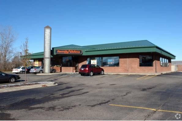
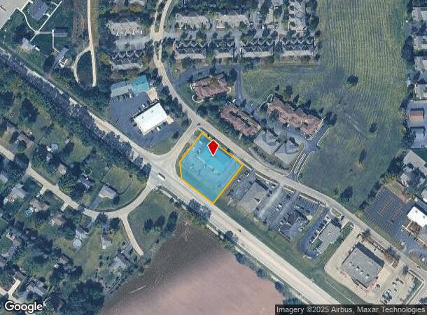
Property Record
4733 Bluestem Rd, Roscoe, IL 61073
NEARBY LISTINGS FOR SALE OR LEASE
Property Detail
4733 Bluestem Rd
Rockford, IL
Prairie Business Center Plat No 2
04-29-428-009
PRAIRIE BUSINESS CENTER PLAT NO 2 PT E1/2 SEC 29-46-2 (EXC THAT PT TO COUNTYBY 05-49161) LOT 12
Commercialnec
Winnebago
X
Illinois
17201C0142E
12
2024
0.97 AC
2024
I-39 Corr/Winnebago Cnty
003904
Chicago
7,162 SF
DEMOGRAPHICS near 4733 Bluestem Rd
1 Mile
3 Mile
5 Mile
2024 Total Population
3,075
24,679
55,909
2029 Population
3,012
24,156
55,177
Pop Growth 2024-2029
(2.05%)
(2.12%)
(1.31%)
Average Age
42
40
40
2024 Total Households
1,195
9,322
21,211
HH Growth 2024-2029
(2.01%)
(2.13%)
(1.26%)
Median Household Inc
$82,770
$92,112
$81,742
Avg Household Size
2.60
2.60
2.60
2024 Avg HH Vehicles
2.00
2.00
2.00
Median Home Value
$167,011
$182,602
$178,117
Median Year Built
1981
1993
1988
Nearby Places
Map Layers
Map Styles
 Street
 Aerial
- Restaurants
- Banks
- Shops
- Fitness
- Groceries
PUBLIC TRANSPORTATION
AIRPORT
Chicago/Rockford International
DRIVE
WALK
Distance
Chicago/Rockford International
38 min
21.7 mi
SALE & LEASE HISTORY
LISTING DATE
SALE/LEASE

Apr 12, 2018
For Lease
Nearby Properties
Address
Land Use
TOTAL SIZE
Lot Size
Zoning
Address
Land Use
TOTAL SIZE
Lot Size
Zoning
33.53 AC
Address
Land Use
TOTAL SIZE
Lot Size
Zoning
121.46 AC
Address
Land Use
TOTAL SIZE
Lot Size
Zoning
66.74 AC
Address
Land Use
TOTAL SIZE
Lot Size
Zoning
8 AC
CN - COMM
Address
Land Use
TOTAL SIZE
Lot Size
Zoning
Address
Land Use
TOTAL SIZE
Lot Size
Zoning
18.56 AC
Address
Land Use
TOTAL SIZE
Lot Size
Zoning
Address
Land Use
TOTAL SIZE
Lot Size
Zoning
8.61 AC
Address
Land Use
TOTAL SIZE
Lot Size
Zoning
82,123 SF
1 AC
Address
Land Use
TOTAL SIZE
Lot Size
Zoning
218,074 SF
39.93 AC
IG GENERAL
Address
Land Use
TOTAL SIZE
Lot Size
Zoning
13.10 AC
Address
Land Use
TOTAL SIZE
Lot Size
Zoning
Address
Land Use
TOTAL SIZE
Lot Size
Zoning
11.42 AC
Address
Land Use
TOTAL SIZE
Lot Size
Zoning
150,668 SF
89.27 AC
Address
Land Use
TOTAL SIZE
Lot Size
Zoning
301,509 SF
10.27 AC
IG GENERAL
Address
Land Use
TOTAL SIZE
Lot Size
Zoning
4.56 AC
Address
Land Use
TOTAL SIZE
Lot Size
Zoning
Address
Land Use
TOTAL SIZE
Lot Size
Zoning
2.22 AC
Address
Land Use
TOTAL SIZE
Lot Size
Zoning
Address
Land Use
TOTAL SIZE
Lot Size
Zoning
7.70 AC
IL LIGHT I
Address
Land Use
TOTAL SIZE
Lot Size
Zoning
29,795 SF
1 AC
Address
Land Use
TOTAL SIZE
Lot Size
Zoning
41,400 SF
9.92 AC
Address
Land Use
TOTAL SIZE
Lot Size
Zoning
Address
Land Use
TOTAL SIZE
Lot Size
Zoning
2.98 AC
Address
Land Use
TOTAL SIZE
Lot Size
Zoning
Address
Land Use
TOTAL SIZE
Lot Size
Zoning
64,527 SF
4.25 AC
IL
Address
Land Use
TOTAL SIZE
Lot Size
Zoning
6.30 AC
Address
Land Use
TOTAL SIZE
Lot Size
Zoning
61,500 SF
5.36 AC
IL
Address
Land Use
TOTAL SIZE
Lot Size
Zoning
67,185 SF
4 AC
Address
Land Use
TOTAL SIZE
Lot Size
Zoning
86,261 SF
12.72 AC
The World's #1 Commercial Real Estate Marketplace
Connect with us
© 2026 CoStar Group
The information above has been obtained from sources believed reliable. While we do not doubt its accuracy we have not verified it and make no guarantee, warranty or representation about it. It is your responsibility to independently confirm its accuracy and completeness. Any projections, opinions, assumptions, or estimates used are for example only and do not represent the current or future performance of the property. The value of this transaction to you depends on tax and other factors which should be evaluated by your tax, financial, and legal advisors. You and your advisors should conduct a careful, independent investigation of the property to determine to your satisfaction the suitability of the property for your needs.