Property Record
4733 E Main St, Columbus, OH 43213
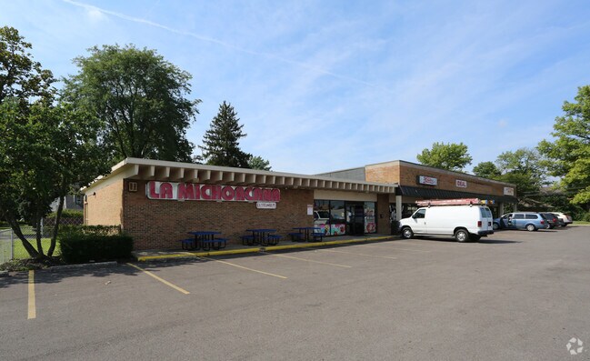

Property Detail
4733 E Main St
Columbus, OH
4733-41 E MAIN ST WALTER W MORRISONS 1 LOT 1
090-001577
Franklin
Regionalshoppingcenterormallwithanchorstore
Ohio
B and X Area of moderate flood hazard, usually the area between the limits of the 100-year and 500-year floods.
1
2024
0.74 AC
2025
East
009340
Columbus
12,520 SF
NEARBY LISTINGS FOR SALE OR LEASE
DEMOGRAPHICS near 4733 E Main St
1 mile
3 mile
5 mile
2024 Total Population
17,310
112,791
262,136
2029 Population
17,679
115,941
271,112
Pop Growth 2024-2029
+ 2.13%
+ 2.79%
+ 3.42%
Average Age
38
38
38
2024 Total Households
6,752
47,209
107,104
HH Growth 2024-2029
+ 2.30%
+ 2.96%
+ 3.61%
Median Household Inc
$52,897
$51,160
$58,200
Avg Household Size
2.50
2.30
2.40
2024 Avg HH Vehicles
2.00
1.00
2.00
Median Home Value
$157,194
$193,128
$242,951
Median Year Built
1964
1968
1973
Nearby Places
Map Layers
Map Styles
 Street
 Aerial
Transit
 Traffic
 Biking
Places
Listings with unknown addresses are not visible on the map
- Restaurants
- Banks
- Shops
- Fitness
- Groceries
SALE & LEASE HISTORY
LISTING DATE
SALE/LEASE

Sep 25, 2016
For Lease
Oct 20, 2023
For Lease
May 31, 2019
For Lease
Dec 09, 2016
For Lease
Nearby Properties
Address
Land Use
TOTAL SIZE
Lot Size
Zoning
Address
Land Use
TOTAL SIZE
Lot Size
Zoning
316,415 SF
415.78 AC
Address
Land Use
TOTAL SIZE
Lot Size
Zoning
761,542 SF
21.30 AC
Address
Land Use
TOTAL SIZE
Lot Size
Zoning
180,383 SF
15.54 AC
Address
Land Use
TOTAL SIZE
Lot Size
Zoning
208,472 SF
1.45 AC
Address
Land Use
TOTAL SIZE
Lot Size
Zoning
164,095 SF
33.71 AC
Address
Land Use
TOTAL SIZE
Lot Size
Zoning
147,649 SF
5.15 AC
Address
Land Use
TOTAL SIZE
Lot Size
Zoning
122,526 SF
27 AC
Address
Land Use
TOTAL SIZE
Lot Size
Zoning
514,341 SF
46.79 AC
Address
Land Use
TOTAL SIZE
Lot Size
Zoning
183,352 SF
55.41 AC
Address
Land Use
TOTAL SIZE
Lot Size
Zoning
282,035 SF
29.29 AC
Address
Land Use
TOTAL SIZE
Lot Size
Zoning
66,177 SF
11.17 AC
Address
Land Use
TOTAL SIZE
Lot Size
Zoning
464,796 SF
7.33 AC
Address
Land Use
TOTAL SIZE
Lot Size
Zoning
166,628 SF
9.98 AC
Address
Land Use
TOTAL SIZE
Lot Size
Zoning
706,471 SF
41.34 AC
Address
Land Use
TOTAL SIZE
Lot Size
Zoning
217,088 SF
10.67 AC
Address
Land Use
TOTAL SIZE
Lot Size
Zoning
1,264,151 SF
58.42 AC
Address
Land Use
TOTAL SIZE
Lot Size
Zoning
125,219 SF
3.49 AC
Address
Land Use
TOTAL SIZE
Lot Size
Zoning
2,117,753 SF
117.95 AC
Address
Land Use
TOTAL SIZE
Lot Size
Zoning
170,209 SF
15.03 AC
Address
Land Use
TOTAL SIZE
Lot Size
Zoning
142,542 SF
6.55 AC
Address
Land Use
TOTAL SIZE
Lot Size
Zoning
188,305 SF
27.46 AC
Address
Land Use
TOTAL SIZE
Lot Size
Zoning
142,542 SF
3.95 AC
Address
Land Use
TOTAL SIZE
Lot Size
Zoning
158,325 SF
34.39 AC
Address
Land Use
TOTAL SIZE
Lot Size
Zoning
102,412 SF
11.86 AC
Address
Land Use
TOTAL SIZE
Lot Size
Zoning
267,596 SF
5.76 AC
Address
Land Use
TOTAL SIZE
Lot Size
Zoning
264,250 SF
10.31 AC
Address
Land Use
TOTAL SIZE
Lot Size
Zoning
159,719 SF
36.24 AC
Address
Land Use
TOTAL SIZE
Lot Size
Zoning
79,472 SF
8.45 AC
Address
Land Use
TOTAL SIZE
Lot Size
Zoning
175,313 SF
27.10 AC
Address
Land Use
TOTAL SIZE
Lot Size
Zoning
58,272 SF
7.86 AC
The World's #1 Commercial Real Estate Marketplace
Connect with us
© 2026 CoStar Group
The information above has been obtained from sources believed reliable. While we do not doubt its accuracy we have not verified it and make no guarantee, warranty or representation about it. It is your responsibility to independently confirm its accuracy and completeness. Any projections, opinions, assumptions, or estimates used are for example only and do not represent the current or future performance of the property. The value of this transaction to you depends on tax and other factors which should be evaluated by your tax, financial, and legal advisors. You and your advisors should conduct a careful, independent investigation of the property to determine to your satisfaction the suitability of the property for your needs.