Property Record
474 E Norwich Ave, Columbus, OH 43201
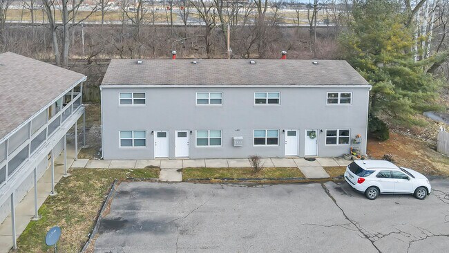

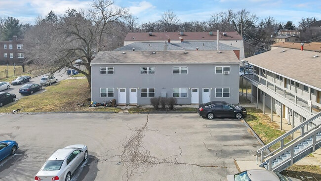

Property Detail
474 E Norwich Ave
Columbus, OH
474 E NORWICH AVENUE INDIANOLA SUMMIT LOT 26THRU29 BLK 18
010-036824
Franklin
Apartment
Ohio
B and X Area of moderate flood hazard, usually the area between the limits of the 100-year and 500-year floods.
26 -
2024
0.57 AC
2025
Indianola Terrace
001200
Columbus
12,096 SF
NEARBY LISTINGS FOR SALE OR LEASE
DEMOGRAPHICS near 474 E Norwich Ave
1 mile
3 mile
5 mile
2025 Total Population
43,689
184,493
404,419
2030 Population
45,793
191,816
420,522
Pop Growth 2025-2030
+ 4.82%
+ 3.97%
+ 3.98%
Average Age
29
34
36
2025 Total Households
15,062
79,271
174,704
HH Growth 2025-2030
+ 5.40%
+ 4.18%
+ 4.21%
Median Household Inc
$39,675
$54,620
$60,896
Avg Household Size
2.30
2.10
2.10
2025 Avg HH Vehicles
2.00
2.00
2.00
Median Home Value
$293,701
$311,989
$342,527
Median Year Built
1971
1962
1963
Nearby Places
Map Layers
Map Styles
 Street
 Aerial
Layers
 Traffic
 Biking
Places
Listings with unknown addresses are not visible on the map
- Restaurants
- Banks
- Shops
- Fitness
- Groceries
PUBLIC TRANSPORTATION
AIRPORT
John Glenn Columbus International
Drive
Walk
Distance
John Glenn Columbus International
15 min
9.4 mi
Rickenbacker International
Drive
Walk
Distance
Rickenbacker International
29 min
18.5 mi
Freight Ports
Port of Toledo
Drive
Walk
Distance
Port of Toledo
181 min
146.6 mi
SALE & LEASE HISTORY
LISTING DATE
SALE/LEASE

Mar 02, 2022
For Sale
Jun 05, 2025
For Sale
Nearby Properties
Address
Land Use
TOTAL SIZE
Lot Size
Zoning
Address
Land Use
TOTAL SIZE
Lot Size
Zoning
1,160,461 SF
328.10 AC
Address
Land Use
TOTAL SIZE
Lot Size
Zoning
3,462,019 SF
54.42 AC
Address
Land Use
TOTAL SIZE
Lot Size
Zoning
344,620 SF
291.96 AC
Address
Land Use
TOTAL SIZE
Lot Size
Zoning
29,312 SF
10.72 AC
Address
Land Use
TOTAL SIZE
Lot Size
Zoning
13.50 AC
Address
Land Use
TOTAL SIZE
Lot Size
Zoning
382,270 SF
319.59 AC
Address
Land Use
TOTAL SIZE
Lot Size
Zoning
Address
Land Use
TOTAL SIZE
Lot Size
Zoning
1,099,074 SF
39.47 AC
Address
Land Use
TOTAL SIZE
Lot Size
Zoning
972,594 SF
0.84 AC
Address
Land Use
TOTAL SIZE
Lot Size
Zoning
501,624 SF
1.23 AC
Address
Land Use
TOTAL SIZE
Lot Size
Zoning
470,630 SF
0.57 AC
Address
Land Use
TOTAL SIZE
Lot Size
Zoning
1,158,978 SF
5.02 AC
Address
Land Use
TOTAL SIZE
Lot Size
Zoning
892,833 SF
5.27 AC
Address
Land Use
TOTAL SIZE
Lot Size
Zoning
388,082 SF
12.41 AC
Address
Land Use
TOTAL SIZE
Lot Size
Zoning
1.64 AC
Address
Land Use
TOTAL SIZE
Lot Size
Zoning
560,146 SF
63.19 AC
Address
Land Use
TOTAL SIZE
Lot Size
Zoning
378,522 SF
41.13 AC
Address
Land Use
TOTAL SIZE
Lot Size
Zoning
657,089 SF
9.74 AC
Address
Land Use
TOTAL SIZE
Lot Size
Zoning
19,117 SF
7.28 AC
Address
Land Use
TOTAL SIZE
Lot Size
Zoning
747,391 SF
3.15 AC
Address
Land Use
TOTAL SIZE
Lot Size
Zoning
4.90 AC
Address
Land Use
TOTAL SIZE
Lot Size
Zoning
2.25 AC
Address
Land Use
TOTAL SIZE
Lot Size
Zoning
240,144 SF
45.78 AC
Address
Land Use
TOTAL SIZE
Lot Size
Zoning
691,902 SF
12.34 AC
Address
Land Use
TOTAL SIZE
Lot Size
Zoning
767,328 SF
5.10 AC
Address
Land Use
TOTAL SIZE
Lot Size
Zoning
800,977 SF
0.77 AC
Address
Land Use
TOTAL SIZE
Lot Size
Zoning
4.46 AC
Address
Land Use
TOTAL SIZE
Lot Size
Zoning
36.42 AC
Address
Land Use
TOTAL SIZE
Lot Size
Zoning
15,968 SF
10 AC
Address
Land Use
TOTAL SIZE
Lot Size
Zoning
34,200 SF
8.10 AC
The World's #1 Commercial Real Estate Marketplace
Connect with us
© 2026 CoStar Group
The information above has been obtained from sources believed reliable. While we do not doubt its accuracy we have not verified it and make no guarantee, warranty or representation about it. It is your responsibility to independently confirm its accuracy and completeness. Any projections, opinions, assumptions, or estimates used are for example only and do not represent the current or future performance of the property. The value of this transaction to you depends on tax and other factors which should be evaluated by your tax, financial, and legal advisors. You and your advisors should conduct a careful, independent investigation of the property to determine to your satisfaction the suitability of the property for your needs.