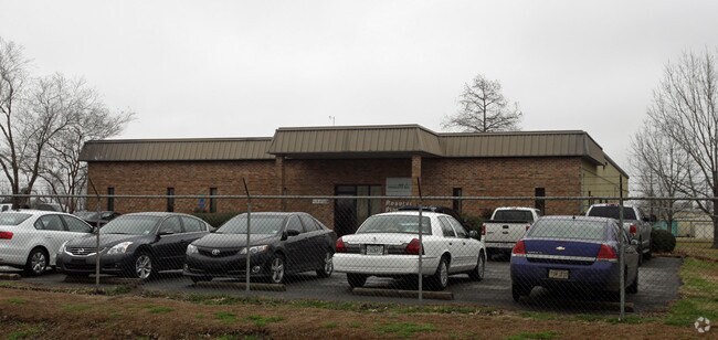
Property Record
474 W 19Th St, Reserve, LA 70084

NEARBY LISTINGS FOR SALE OR LEASE
-
-
View all Reserve listings for sale on LoopNet.com
Property Detail
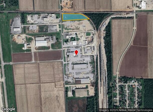
474 W 19Th St
New Orleans-Metairie, LA
Reserve Ind Park
0500269350
199/755 255/344 PORTION LOT 1A RESERVE IND PARK 317/556; 345/256 LESS LOT 6-A3-1; LOT 6B (50.12'X37.57'X481.86'X251.52'X32.19'X714.43'X189.76' 278/336
Commercialnec
St John Baptist
X
Louisiana
22095C0205D
2,1a,6b
2025
7 AC
2024
St John Baptist Parish
070700
New Orleans/Metairie/Kenner
DEMOGRAPHICS near 474 W 19Th St
1 mile
3 mile
5 mile
2024 Total Population
890
7,889
18,362
2029 Population
839
7,266
17,106
Pop Growth 2024-2029
(5.73%)
(7.90%)
(6.84%)
Average Age
46
42
40
2024 Total Households
325
3,051
6,899
HH Growth 2024-2029
(5.54%)
(7.74%)
(6.62%)
Median Household Inc
$36,750
$49,580
$54,005
Avg Household Size
2.40
2.50
2.60
2024 Avg HH Vehicles
2.00
2.00
2.00
Median Home Value
$104,348
$141,238
$155,416
Median Year Built
1971
1972
1978
Nearby Places
Map Layers
Map Styles
 Street
 Aerial
Transit
 Traffic
 Biking
Places
Listings with unknown addresses are not visible on the map
- Restaurants
- Banks
- Shops
- Fitness
- Groceries
PUBLIC TRANSPORTATION
AIRPORT
Louis Armstrong New Orleans International
Drive
Walk
Distance
Louis Armstrong New Orleans International
33 min
23.0 mi
Freight Ports
Port of New Orleans
Drive
Walk
Distance
Port of New Orleans
54 min
37.6 mi
Nearby Properties
Address
Land Use
TOTAL SIZE
Lot Size
Zoning
Address
Land Use
TOTAL SIZE
Lot Size
Zoning
Address
Land Use
TOTAL SIZE
Lot Size
Zoning
Address
Land Use
TOTAL SIZE
Lot Size
Zoning
Address
Land Use
TOTAL SIZE
Lot Size
Zoning
9,845.43 AC
Address
Land Use
TOTAL SIZE
Lot Size
Zoning
Address
Land Use
TOTAL SIZE
Lot Size
Zoning
Address
Land Use
TOTAL SIZE
Lot Size
Zoning
Address
Land Use
TOTAL SIZE
Lot Size
Zoning
Address
Land Use
TOTAL SIZE
Lot Size
Zoning
Address
Land Use
TOTAL SIZE
Lot Size
Zoning
Address
Land Use
TOTAL SIZE
Lot Size
Zoning
Address
Land Use
TOTAL SIZE
Lot Size
Zoning
Address
Land Use
TOTAL SIZE
Lot Size
Zoning
Address
Land Use
TOTAL SIZE
Lot Size
Zoning
Address
Land Use
TOTAL SIZE
Lot Size
Zoning
Address
Land Use
TOTAL SIZE
Lot Size
Zoning
Address
Land Use
TOTAL SIZE
Lot Size
Zoning
1.04 AC
Address
Land Use
TOTAL SIZE
Lot Size
Zoning
Address
Land Use
TOTAL SIZE
Lot Size
Zoning
1.24 AC
Address
Land Use
TOTAL SIZE
Lot Size
Zoning
Address
Land Use
TOTAL SIZE
Lot Size
Zoning
Address
Land Use
TOTAL SIZE
Lot Size
Zoning
Address
Land Use
TOTAL SIZE
Lot Size
Zoning
Address
Land Use
TOTAL SIZE
Lot Size
Zoning
Address
Land Use
TOTAL SIZE
Lot Size
Zoning
Address
Land Use
TOTAL SIZE
Lot Size
Zoning
2,160 AC
Address
Land Use
TOTAL SIZE
Lot Size
Zoning
Address
Land Use
TOTAL SIZE
Lot Size
Zoning
Address
Land Use
TOTAL SIZE
Lot Size
Zoning
The World's #1 Commercial Real Estate Marketplace
Connect with us
© 2026 CoStar Group
The information above has been obtained from sources believed reliable. While we do not doubt its accuracy we have not verified it and make no guarantee, warranty or representation about it. It is your responsibility to independently confirm its accuracy and completeness. Any projections, opinions, assumptions, or estimates used are for example only and do not represent the current or future performance of the property. The value of this transaction to you depends on tax and other factors which should be evaluated by your tax, financial, and legal advisors. You and your advisors should conduct a careful, independent investigation of the property to determine to your satisfaction the suitability of the property for your needs.