Property Record
4743 Gratiot Ave, Saint Clair, MI 48079

Property Detail
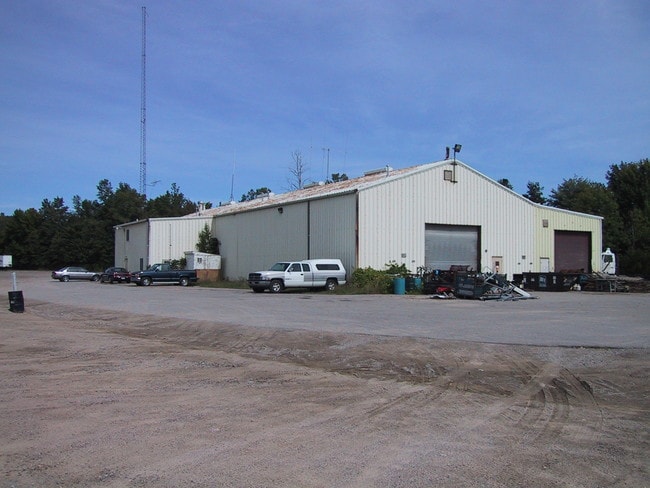
4743 Gratiot Ave
30-001-1026-000
BEG S 88D 52M W 147.43', S 60D 52M 11S W 49.23' & S 32D 58M 38S E 60.14' FROM N 1/4 COR, TH N 60D 52M 11S E 100', TH S 32D 58M 38S E 432.23', TH N 60D 47M 22S E 40.20', TH S 01D 36M 38S E 807.25', TH S 88D 09M 22S W 322.62', TH N 44D 51M 56S W 468.85
Warehouse
Saint Clair
I-1
Michigan
B and X Area of moderate flood hazard, usually the area between the limits of the 100-year and 500-year floods.
9.31 AC
2025
St Clair & Lapeer Counties
2025
Detroit
640600
Detroit-Warren-Dearborn, MI
12,840 SF
NEARBY LISTINGS FOR SALE OR LEASE
DEMOGRAPHICS near 4743 Gratiot Ave
1 mile
3 mile
5 mile
2025 Total Population
1,644
14,477
28,896
2030 Population
1,635
14,431
28,896
Pop Growth 2025-2030
(0.55%)
(0.32%)
0.00%
Average Age
42
42
42
2025 Total Households
661
5,861
11,549
HH Growth 2025-2030
(0.61%)
(0.43%)
(0.10%)
Median Household Inc
$79,439
$70,664
$65,388
Avg Household Size
2.40
2.40
2.40
2025 Avg HH Vehicles
2.00
2.00
2.00
Median Home Value
$224,062
$207,612
$211,285
Median Year Built
1982
1980
1980
Nearby Places
Map Layers
Map Styles
 Street
 Aerial
Layers
 Traffic
 Biking
Places
Listings with unknown addresses are not visible on the map
- Restaurants
- Banks
- Shops
- Fitness
- Groceries
PUBLIC TRANSPORTATION
COMMUTER RAIL
Drive
Walk
Distance
11 min
5.7 mi
Nearby Properties
Address
Land Use
TOTAL SIZE
Lot Size
Zoning
Address
Land Use
TOTAL SIZE
Lot Size
Zoning
682,515 SF
211.45 AC
M-2
Address
Land Use
TOTAL SIZE
Lot Size
Zoning
79,276 SF
316.65 AC
M-1
Address
Land Use
TOTAL SIZE
Lot Size
Zoning
1,246,586 SF
83.70 AC
M-2
Address
Land Use
TOTAL SIZE
Lot Size
Zoning
98,904 SF
29.48 AC
R1-A
Address
Land Use
TOTAL SIZE
Lot Size
Zoning
79,276 SF
311.74 AC
M-1
Address
Land Use
TOTAL SIZE
Lot Size
Zoning
204,347 SF
35.13 AC
C-2
Address
Land Use
TOTAL SIZE
Lot Size
Zoning
134,379 SF
15 AC
RM-2
Address
Land Use
TOTAL SIZE
Lot Size
Zoning
80,662 SF
R1-A
Address
Land Use
TOTAL SIZE
Lot Size
Zoning
138,360 SF
6.01 AC
M-1
Address
Land Use
TOTAL SIZE
Lot Size
Zoning
Address
Land Use
TOTAL SIZE
Lot Size
Zoning
77,868 SF
8.91 AC
RM-2
Address
Land Use
TOTAL SIZE
Lot Size
Zoning
108,767 SF
7.29 AC
R1-A
Address
Land Use
TOTAL SIZE
Lot Size
Zoning
83,623 SF
5.49 AC
M-1
Address
Land Use
TOTAL SIZE
Lot Size
Zoning
250,775 SF
11.29 AC
M-1
Address
Land Use
TOTAL SIZE
Lot Size
Zoning
69,440 SF
12.30 AC
C-2
Address
Land Use
TOTAL SIZE
Lot Size
Zoning
100,096 SF
13.85 AC
M-2
Address
Land Use
TOTAL SIZE
Lot Size
Zoning
50,314 SF
58.60 AC
M-2
Address
Land Use
TOTAL SIZE
Lot Size
Zoning
68,348 SF
6.33 AC
M-1
Address
Land Use
TOTAL SIZE
Lot Size
Zoning
37,998 SF
6.04 AC
C-2
Address
Land Use
TOTAL SIZE
Lot Size
Zoning
28,565 SF
R1-A
Address
Land Use
TOTAL SIZE
Lot Size
Zoning
5,213 SF
45 AC
I-2
Address
Land Use
TOTAL SIZE
Lot Size
Zoning
55,760 SF
7.86 AC
M-1
Address
Land Use
TOTAL SIZE
Lot Size
Zoning
18,000 SF
9.62 AC
M-1
Address
Land Use
TOTAL SIZE
Lot Size
Zoning
16,621 SF
3.63 AC
C-3
Address
Land Use
TOTAL SIZE
Lot Size
Zoning
29,312 SF
2 AC
R1-A
Address
Land Use
TOTAL SIZE
Lot Size
Zoning
72,284 SF
8.07 AC
C-2
Address
Land Use
TOTAL SIZE
Lot Size
Zoning
129,642 SF
10.49 AC
M-1
Address
Land Use
TOTAL SIZE
Lot Size
Zoning
896 SF
41.22 AC
RMH
Address
Land Use
TOTAL SIZE
Lot Size
Zoning
90,124 SF
13.30 AC
C-2
Address
Land Use
TOTAL SIZE
Lot Size
Zoning
10,366 SF
2.39 AC
C-3
The World's #1 Commercial Real Estate Marketplace
Connect with us
© 2026 CoStar Group
The information above has been obtained from sources believed reliable. While we do not doubt its accuracy we have not verified it and make no guarantee, warranty or representation about it. It is your responsibility to independently confirm its accuracy and completeness. Any projections, opinions, assumptions, or estimates used are for example only and do not represent the current or future performance of the property. The value of this transaction to you depends on tax and other factors which should be evaluated by your tax, financial, and legal advisors. You and your advisors should conduct a careful, independent investigation of the property to determine to your satisfaction the suitability of the property for your needs.