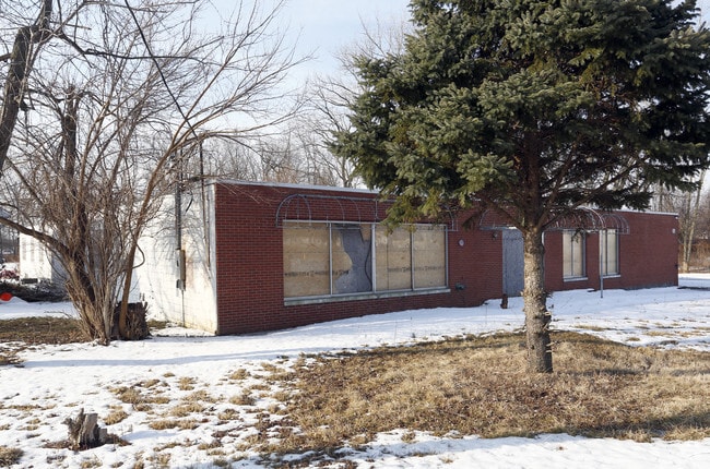
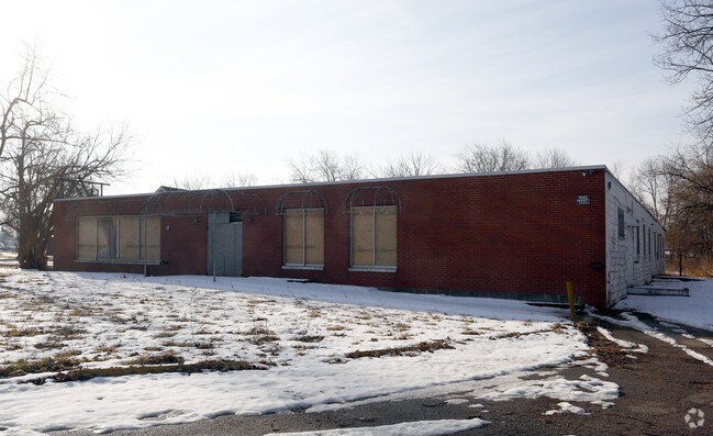
Property Record
4743 Southeastern Ave, Indianapolis, IN 46203
NEARBY LISTINGS FOR SALE OR LEASE
Property Detail
4743 Southeastern Ave
Indianapolis-Carmel-Anderson, IN
Shanks S Eastern Pk
49-10-16-106-006.000-101
SHANKS S EASTERN PK L6
Commercialacreage
Marion
X
Indiana
18097C0252F
6
2023
1.59 AC
2024
Beech Grove/SE County
357400
Indianapolis
DEMOGRAPHICS near 4743 Southeastern Ave
1 Mile
3 Mile
5 Mile
2024 Total Population
7,627
99,326
247,221
2029 Population
7,547
99,528
247,324
Pop Growth 2024-2029
(1.05%)
+ 0.20%
+ 0.04%
Average Age
38
37
37
2024 Total Households
2,901
40,923
104,211
HH Growth 2024-2029
(1.14%)
+ 0.09%
+ 0.05%
Median Household Inc
$52,690
$49,749
$53,894
Avg Household Size
2.50
2.30
2.30
2024 Avg HH Vehicles
2.00
2.00
2.00
Median Home Value
$86,754
$146,783
$164,658
Median Year Built
1955
1949
1959
Nearby Places
Map Layers
Map Styles
 Street
 Aerial
- Restaurants
- Banks
- Shops
- Fitness
- Groceries
PUBLIC TRANSPORTATION
COMMUTER RAIL
Indianapolis (Cardinal - Amtrak)
DRIVE
WALK
Distance
Indianapolis (Cardinal - Amtrak)
8 min
4.2 mi
AIRPORT
Indianapolis International
DRIVE
WALK
Distance
Indianapolis International
30 min
16.3 mi
Freight Ports
Port of Toledo
DRIVE
WALK
Distance
Port of Toledo
271 min
226.3 mi
SALE & LEASE HISTORY
LISTING DATE
SALE/LEASE

Sep 23, 2016
For Sale
Nearby Properties
Address
Land Use
TOTAL SIZE
Lot Size
Zoning
Address
Land Use
TOTAL SIZE
Lot Size
Zoning
41.83 AC
ZO01
Address
Land Use
TOTAL SIZE
Lot Size
Zoning
1,202,700 SF
77.25 AC
ZO01
Address
Land Use
TOTAL SIZE
Lot Size
Zoning
25,146 SF
28.58 AC
ZO01
Address
Land Use
TOTAL SIZE
Lot Size
Zoning
47.10 AC
ZO01
Address
Land Use
TOTAL SIZE
Lot Size
Zoning
9,888 SF
124.20 AC
ZO01
Address
Land Use
TOTAL SIZE
Lot Size
Zoning
2,451 SF
0.46 AC
ZO01
Address
Land Use
TOTAL SIZE
Lot Size
Zoning
83,616 SF
3.57 AC
ZO01
Address
Land Use
TOTAL SIZE
Lot Size
Zoning
3.82 AC
ZO01
Address
Land Use
TOTAL SIZE
Lot Size
Zoning
405,664 SF
35.56 AC
ZO01
Address
Land Use
TOTAL SIZE
Lot Size
Zoning
1,660 SF
15.01 AC
ZO01
Address
Land Use
TOTAL SIZE
Lot Size
Zoning
2,331 SF
1.38 AC
ZO01
Address
Land Use
TOTAL SIZE
Lot Size
Zoning
3,523 SF
2.39 AC
ZO01
Address
Land Use
TOTAL SIZE
Lot Size
Zoning
3,280 SF
1.04 AC
ZO01
Address
Land Use
TOTAL SIZE
Lot Size
Zoning
11,000 SF
0.71 AC
ZO01
Address
Land Use
TOTAL SIZE
Lot Size
Zoning
81,013 SF
1.23 AC
ZO01
Address
Land Use
TOTAL SIZE
Lot Size
Zoning
71,800 SF
1.88 AC
ZO01
Address
Land Use
TOTAL SIZE
Lot Size
Zoning
1,575 SF
10.24 AC
Address
Land Use
TOTAL SIZE
Lot Size
Zoning
1,040 SF
15.62 AC
ZO01
Address
Land Use
TOTAL SIZE
Lot Size
Zoning
77,518 SF
11.69 AC
ZO01
Address
Land Use
TOTAL SIZE
Lot Size
Zoning
616,065 SF
51.20 AC
ZO01
Address
Land Use
TOTAL SIZE
Lot Size
Zoning
209,756 SF
12.33 AC
ZO01
Address
Land Use
TOTAL SIZE
Lot Size
Zoning
87,807 SF
9.04 AC
ZO01
Address
Land Use
TOTAL SIZE
Lot Size
Zoning
151,946 SF
15.04 AC
Address
Land Use
TOTAL SIZE
Lot Size
Zoning
20,944 SF
8.27 AC
ZO01
Address
Land Use
TOTAL SIZE
Lot Size
Zoning
14,482 SF
8.89 AC
ZO01
Address
Land Use
TOTAL SIZE
Lot Size
Zoning
5,202 SF
26.63 AC
ZO01
Address
Land Use
TOTAL SIZE
Lot Size
Zoning
13,876 SF
28.93 AC
ZO01
Address
Land Use
TOTAL SIZE
Lot Size
Zoning
25,047 SF
0.45 AC
ZO01
Address
Land Use
TOTAL SIZE
Lot Size
Zoning
43,106 SF
0.77 AC
ZO01
Address
Land Use
TOTAL SIZE
Lot Size
Zoning
1.85 AC
ZO01
The World's #1 Commercial Real Estate Marketplace
Connect with us
© 2025 CoStar Group
The information above has been obtained from sources believed reliable. While we do not doubt its accuracy we have not verified it and make no guarantee, warranty or representation about it. It is your responsibility to independently confirm its accuracy and completeness. Any projections, opinions, assumptions, or estimates used are for example only and do not represent the current or future performance of the property. The value of this transaction to you depends on tax and other factors which should be evaluated by your tax, financial, and legal advisors. You and your advisors should conduct a careful, independent investigation of the property to determine to your satisfaction the suitability of the property for your needs.