Property Record
4744 Engle Rd, Carmichael, CA 95608
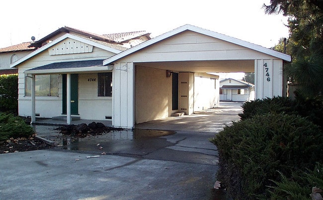


Property Detail
4744 Engle Rd
256-0101-021
POR NW 1/4 OF NW 1/4 SE 1/4 SEC 45 RANCHO DEL PASO DES AS BEG AT A PT LOC E 510.51 FT FR NW COROF SE 1/4 SD SEC TH S 276 FT TH N 89%02 1/2' E 54.86 FT TH N 276 FT TH S 89%02 1/2' W 54.86 FT TO BEG
Multifamilydwelling
Sacramento
BP (NPA)
California
B and X Area of moderate flood hazard, usually the area between the limits of the 100-year and 500-year floods.
0.31 AC
2024
Carmichael/Fair Oaks
2025
Sacramento
005901
Sacramento-Roseville-Folsom, CA
1,812 SF
NEARBY LISTINGS FOR SALE OR LEASE
DEMOGRAPHICS near 4744 Engle Rd
1 mile
3 mile
5 mile
2025 Total Population
15,949
141,104
390,464
2030 Population
15,972
142,237
394,302
Pop Growth 2025-2030
+ 0.14%
+ 0.80%
+ 0.98%
Average Age
45
41
40
2025 Total Households
6,239
55,270
148,860
HH Growth 2025-2030
+ 0.10%
+ 0.82%
+ 1.00%
Median Household Inc
$95,402
$75,375
$77,507
Avg Household Size
2.40
2.50
2.50
2025 Avg HH Vehicles
2.00
2.00
2.00
Median Home Value
$584,936
$545,792
$466,093
Median Year Built
1968
1970
1971
Nearby Places
Map Layers
Map Styles
 Street
 Aerial
Transit
 Traffic
 Biking
Places
Listings with unknown addresses are not visible on the map
- Restaurants
- Banks
- Shops
- Fitness
- Groceries
PUBLIC TRANSPORTATION
AIRPORT
Sacramento International
Drive
Walk
Distance
Sacramento International
27 min
18.1 mi
Freight Ports
Port of Stockton
Drive
Walk
Distance
Port of Stockton
69 min
57.6 mi
Nearby Properties
Address
Land Use
TOTAL SIZE
Lot Size
Zoning
Address
Land Use
TOTAL SIZE
Lot Size
Zoning
512,630 SF
37.68 AC
SPA (NPA)
Address
Land Use
TOTAL SIZE
Lot Size
Zoning
224,595 SF
42.03 AC
SPA
Address
Land Use
TOTAL SIZE
Lot Size
Zoning
430,406 SF
24.45 AC
RD-20
Address
Land Use
TOTAL SIZE
Lot Size
Zoning
152,000 SF
12.88 AC
SPA
Address
Land Use
TOTAL SIZE
Lot Size
Zoning
145,334 SF
8.84 AC
RD-20
Address
Land Use
TOTAL SIZE
Lot Size
Zoning
278,877 SF
13.17 AC
RD-30
Address
Land Use
TOTAL SIZE
Lot Size
Zoning
75,700 SF
4.02 AC
RD-40
Address
Land Use
TOTAL SIZE
Lot Size
Zoning
21,890 SF
0.50 AC
SC
Address
Land Use
TOTAL SIZE
Lot Size
Zoning
170,556 SF
8.41 AC
SPA
Address
Land Use
TOTAL SIZE
Lot Size
Zoning
136,483 SF
3.77 AC
BP
Address
Land Use
TOTAL SIZE
Lot Size
Zoning
106,700 SF
5.38 AC
RD-30
Address
Land Use
TOTAL SIZE
Lot Size
Zoning
130,507 SF
8.97 AC
RD-20
Address
Land Use
TOTAL SIZE
Lot Size
Zoning
138,263 SF
9.92 AC
SC
Address
Land Use
TOTAL SIZE
Lot Size
Zoning
140,102 SF
3.30 AC
RD-20
Address
Land Use
TOTAL SIZE
Lot Size
Zoning
123,622 SF
5.93 AC
RD-20
Address
Land Use
TOTAL SIZE
Lot Size
Zoning
89,098 SF
4.93 AC
RD-40
Address
Land Use
TOTAL SIZE
Lot Size
Zoning
148,576 SF
4.84 AC
RD-30
Address
Land Use
TOTAL SIZE
Lot Size
Zoning
43,183 SF
12.35 AC
H F
Address
Land Use
TOTAL SIZE
Lot Size
Zoning
101,301 SF
9.35 AC
SC
Address
Land Use
TOTAL SIZE
Lot Size
Zoning
72,119 SF
2.38 AC
BP (NPA)
Address
Land Use
TOTAL SIZE
Lot Size
Zoning
1,484 SF
4.94 AC
RD-20
Address
Land Use
TOTAL SIZE
Lot Size
Zoning
185,550 SF
8.67 AC
SC
Address
Land Use
TOTAL SIZE
Lot Size
Zoning
90,972 SF
2.36 AC
RD-40
Address
Land Use
TOTAL SIZE
Lot Size
Zoning
135,053 SF
6.66 AC
LC SC RD-4
Address
Land Use
TOTAL SIZE
Lot Size
Zoning
110,533 SF
4.17 AC
RD-5 RD-40
Address
Land Use
TOTAL SIZE
Lot Size
Zoning
100,529 SF
13.65 AC
RD-10 BP
Address
Land Use
TOTAL SIZE
Lot Size
Zoning
166,300 SF
8.04 AC
RD-40 RD-2
Address
Land Use
TOTAL SIZE
Lot Size
Zoning
145,200 SF
5.39 AC
SC
Address
Land Use
TOTAL SIZE
Lot Size
Zoning
103,414 SF
5.01 AC
RD-30
Address
Land Use
TOTAL SIZE
Lot Size
Zoning
106,437 SF
4.73 AC
RD-30
The World's #1 Commercial Real Estate Marketplace
Connect with us
© 2026 CoStar Group
The information above has been obtained from sources believed reliable. While we do not doubt its accuracy we have not verified it and make no guarantee, warranty or representation about it. It is your responsibility to independently confirm its accuracy and completeness. Any projections, opinions, assumptions, or estimates used are for example only and do not represent the current or future performance of the property. The value of this transaction to you depends on tax and other factors which should be evaluated by your tax, financial, and legal advisors. You and your advisors should conduct a careful, independent investigation of the property to determine to your satisfaction the suitability of the property for your needs.