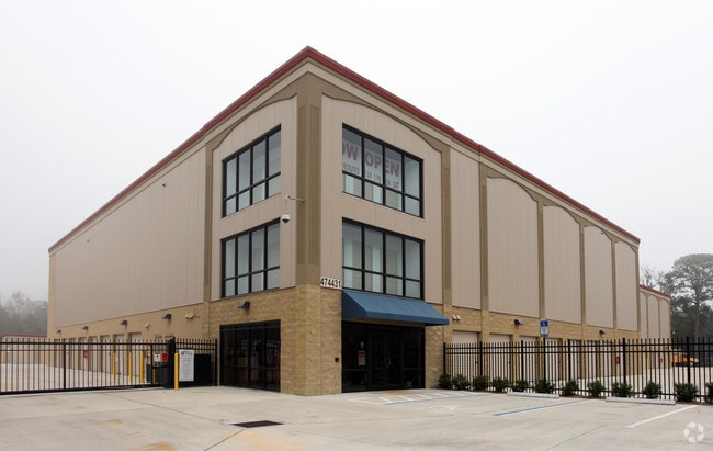
Property Record
474431 E State Road 200, Fernandina Beach, FL 32034

NEARBY LISTINGS FOR SALE OR LEASE
Property Detail
474431 E State Road 200
Jacksonville (Florida)
Fernandina Heights
Jacksonville, FL
IN OR 1633/1018 PARCELS 25 & 26 EX 25-1 EX R/W OR 213/79 & OR 210/525
40-2N-28-0000-0025-0000
Nassau
Shipyard
Florida
2025
25
2025
2.65 AC
050308
Nassau County
105,105 SF
DEMOGRAPHICS near 474431 E State Road 200
1 Mile
3 Mile
5 Mile
2024 Total Population
3,103
20,176
54,022
2029 Population
3,799
24,494
65,746
Pop Growth 2024-2029
+ 22.43%
+ 21.40%
+ 21.70%
Average Age
44
44
47
2024 Total Households
1,293
8,102
22,860
HH Growth 2024-2029
+ 23.51%
+ 22.61%
+ 22.97%
Median Household Inc
$86,399
$95,092
$84,046
Avg Household Size
2.40
2.50
2.30
2024 Avg HH Vehicles
2.00
2.00
2.00
Median Home Value
$389,062
$362,892
$371,519
Median Year Built
2010
2009
2001
Nearby Places
Map Layers
Map Styles
 Street
 Aerial
- Restaurants
- Banks
- Shops
- Fitness
- Groceries
PUBLIC TRANSPORTATION
AIRPORT
Jacksonville International
DRIVE
WALK
Distance
Jacksonville International
34 min
19.4 mi
Freight Ports
Jacksonville Port
DRIVE
WALK
Distance
Jacksonville Port
44 min
30.9 mi
Nearby Properties
Address
Land Use
TOTAL SIZE
Lot Size
Zoning
Address
Land Use
TOTAL SIZE
Lot Size
Zoning
97,988 SF
513.95 AC
I-1
Address
Land Use
TOTAL SIZE
Lot Size
Zoning
282,898 SF
22.88 AC
RG-2
Address
Land Use
TOTAL SIZE
Lot Size
Zoning
221,536 SF
11.16 AC
C-2
Address
Land Use
TOTAL SIZE
Lot Size
Zoning
210,010 SF
19.36 AC
RG-1
Address
Land Use
TOTAL SIZE
Lot Size
Zoning
134,407 SF
2.77 AC
PUD
Address
Land Use
TOTAL SIZE
Lot Size
Zoning
Address
Land Use
TOTAL SIZE
Lot Size
Zoning
63,363 SF
10.41 AC
PUD
Address
Land Use
TOTAL SIZE
Lot Size
Zoning
66,417 SF
8.75 AC
PUD
Address
Land Use
TOTAL SIZE
Lot Size
Zoning
163,686 SF
28.08 AC
CI
Address
Land Use
TOTAL SIZE
Lot Size
Zoning
145,581 SF
3 AC
CG
Address
Land Use
TOTAL SIZE
Lot Size
Zoning
59,770 SF
8.51 AC
GPU
Address
Land Use
TOTAL SIZE
Lot Size
Zoning
48,863 SF
40.38 AC
RG-1
Address
Land Use
TOTAL SIZE
Lot Size
Zoning
125,733 SF
10.89 AC
IW
Address
Land Use
TOTAL SIZE
Lot Size
Zoning
109,094 SF
11.03 AC
IW
Address
Land Use
TOTAL SIZE
Lot Size
Zoning
54,600 SF
6.83 AC
RG-1
Address
Land Use
TOTAL SIZE
Lot Size
Zoning
44,933 SF
5.03 AC
PUD
Address
Land Use
TOTAL SIZE
Lot Size
Zoning
24.41 AC
IW
Address
Land Use
TOTAL SIZE
Lot Size
Zoning
89,600 SF
1.87 AC
CI
Address
Land Use
TOTAL SIZE
Lot Size
Zoning
35,660 SF
10.05 AC
OR
Address
Land Use
TOTAL SIZE
Lot Size
Zoning
44,734 SF
9.59 AC
OR
Address
Land Use
TOTAL SIZE
Lot Size
Zoning
35,296 SF
6.72 AC
PUD
Address
Land Use
TOTAL SIZE
Lot Size
Zoning
32,449 SF
7.57 AC
CI
Address
Land Use
TOTAL SIZE
Lot Size
Zoning
48,460 SF
14.60 AC
PUD
Address
Land Use
TOTAL SIZE
Lot Size
Zoning
50,286 SF
4.39 AC
PUD
Address
Land Use
TOTAL SIZE
Lot Size
Zoning
Address
Land Use
TOTAL SIZE
Lot Size
Zoning
35,463 SF
9.08 AC
PUD
Address
Land Use
TOTAL SIZE
Lot Size
Zoning
33,818 SF
2.88 AC
CI
Address
Land Use
TOTAL SIZE
Lot Size
Zoning
12,927 SF
8.03 AC
OR
Address
Land Use
TOTAL SIZE
Lot Size
Zoning
71.76 AC
OR
The World's #1 Commercial Real Estate Marketplace
Connect with us
© 2025 CoStar Group
The information above has been obtained from sources believed reliable. While we do not doubt its accuracy we have not verified it and make no guarantee, warranty or representation about it. It is your responsibility to independently confirm its accuracy and completeness. Any projections, opinions, assumptions, or estimates used are for example only and do not represent the current or future performance of the property. The value of this transaction to you depends on tax and other factors which should be evaluated by your tax, financial, and legal advisors. You and your advisors should conduct a careful, independent investigation of the property to determine to your satisfaction the suitability of the property for your needs.