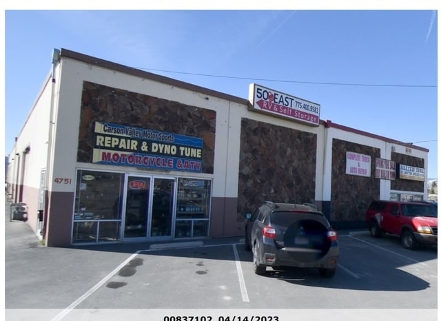
Property Record
4749 Us Highway 50 E, Carson City, NV 89701

Property Detail
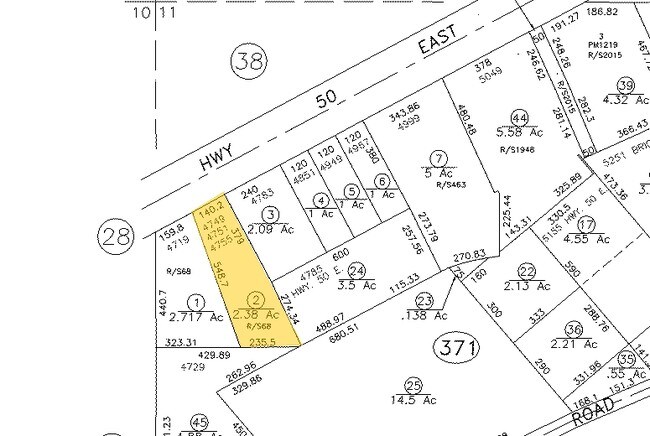
4749 Us Highway 50 E
008-371-02
ADDITIONAL BUILDING ON PROPERTY
Commercialnec
Carson City
GI
Nevada
C and X Area of minimal flood hazard, usually depicted on FIRMs as above the 500-year flood level.
2.38 AC
2025
Carson City County
2025
Reno/Sparks
001002
Carson City, NV
18,400 SF
NEARBY LISTINGS FOR SALE OR LEASE
-
-
View all Carson City listings for lease on LoopNet.com
DEMOGRAPHICS near 4749 Us Highway 50 E
1 mile
3 mile
5 mile
2025 Total Population
4,969
31,019
56,472
2030 Population
4,869
30,883
56,288
Pop Growth 2025-2030
(2.01%)
(0.44%)
(0.33%)
Average Age
40
41
43
2025 Total Households
1,851
12,483
22,804
HH Growth 2025-2030
(2.27%)
(0.57%)
(0.33%)
Median Household Inc
$67,159
$65,297
$69,802
Avg Household Size
2.60
2.40
2.30
2025 Avg HH Vehicles
2.00
2.00
2.00
Median Home Value
$377,333
$384,234
$434,667
Median Year Built
1978
1981
1981
Nearby Places
Map Layers
Map Styles
 Street
 Aerial
Layers
 Traffic
 Biking
Places
Listings with unknown addresses are not visible on the map
- Restaurants
- Banks
- Shops
- Fitness
- Groceries
PUBLIC TRANSPORTATION
AIRPORT
Reno/Tahoe International
Drive
Walk
Distance
Reno/Tahoe International
53 min
32.8 mi
Freight Ports
Port of Stockton
Drive
Walk
Distance
Port of Stockton
222 min
154.6 mi
SALE & LEASE HISTORY
LISTING DATE
SALE/LEASE

Oct 17, 2024
For Lease
Nearby Properties
Address
Land Use
TOTAL SIZE
Lot Size
Zoning
Address
Land Use
TOTAL SIZE
Lot Size
Zoning
356,776 SF
64.42 AC
P
Address
Land Use
TOTAL SIZE
Lot Size
Zoning
175,233 SF
5.88 AC
PR
Address
Land Use
TOTAL SIZE
Lot Size
Zoning
7,419 SF
0.71 AC
PR
Address
Land Use
TOTAL SIZE
Lot Size
Zoning
272,519 SF
102.35 AC
P
Address
Land Use
TOTAL SIZE
Lot Size
Zoning
96,057 SF
10 AC
LI
Address
Land Use
TOTAL SIZE
Lot Size
Zoning
213,246 SF
19.48 AC
GC-RC
Address
Land Use
TOTAL SIZE
Lot Size
Zoning
240 AC
PR
Address
Land Use
TOTAL SIZE
Lot Size
Zoning
109,200 SF
9.35 AC
GC
Address
Land Use
TOTAL SIZE
Lot Size
Zoning
89,408 SF
39.22 AC
P
Address
Land Use
TOTAL SIZE
Lot Size
Zoning
29.98 AC
PC
Address
Land Use
TOTAL SIZE
Lot Size
Zoning
375 SF
520 AC
PR
Address
Land Use
TOTAL SIZE
Lot Size
Zoning
178.40 AC
PR
Address
Land Use
TOTAL SIZE
Lot Size
Zoning
111,950 SF
18.20 AC
RC-MHP
Address
Land Use
TOTAL SIZE
Lot Size
Zoning
113,007 SF
52.90 AC
PR
Address
Land Use
TOTAL SIZE
Lot Size
Zoning
4,685 SF
49.08 AC
PR
Address
Land Use
TOTAL SIZE
Lot Size
Zoning
156,408 SF
2.08 AC
MFA-GC
Address
Land Use
TOTAL SIZE
Lot Size
Zoning
160 AC
PR
Address
Land Use
TOTAL SIZE
Lot Size
Zoning
125,780 SF
28.21 AC
P
Address
Land Use
TOTAL SIZE
Lot Size
Zoning
160,769 SF
15 AC
LI
Address
Land Use
TOTAL SIZE
Lot Size
Zoning
86,783 SF
52 AC
PR
Address
Land Use
TOTAL SIZE
Lot Size
Zoning
20,800 SF
2.90 AC
GC
Address
Land Use
TOTAL SIZE
Lot Size
Zoning
68,342 SF
2.47 AC
TC
Address
Land Use
TOTAL SIZE
Lot Size
Zoning
256.42 AC
Address
Land Use
TOTAL SIZE
Lot Size
Zoning
59,130 SF
7.27 AC
P
Address
Land Use
TOTAL SIZE
Lot Size
Zoning
45,406 SF
5.93 AC
Address
Land Use
TOTAL SIZE
Lot Size
Zoning
107,063 SF
10.96 AC
GC
Address
Land Use
TOTAL SIZE
Lot Size
Zoning
70,763 SF
9.54 AC
P
Address
Land Use
TOTAL SIZE
Lot Size
Zoning
85,751 SF
3.41 AC
Address
Land Use
TOTAL SIZE
Lot Size
Zoning
71,719 SF
1.89 AC
MFA
Address
Land Use
TOTAL SIZE
Lot Size
Zoning
30,481 SF
4.94 AC
The World's #1 Commercial Real Estate Marketplace
Connect with us
© 2026 CoStar Group
The information above has been obtained from sources believed reliable. While we do not doubt its accuracy we have not verified it and make no guarantee, warranty or representation about it. It is your responsibility to independently confirm its accuracy and completeness. Any projections, opinions, assumptions, or estimates used are for example only and do not represent the current or future performance of the property. The value of this transaction to you depends on tax and other factors which should be evaluated by your tax, financial, and legal advisors. You and your advisors should conduct a careful, independent investigation of the property to determine to your satisfaction the suitability of the property for your needs.