Property Record
475 Bill Kennedy Way Se, Atlanta, GA 30316
Current Lease Availabilities
NEARBY LISTINGS FOR SALE OR LEASE
Property Detail
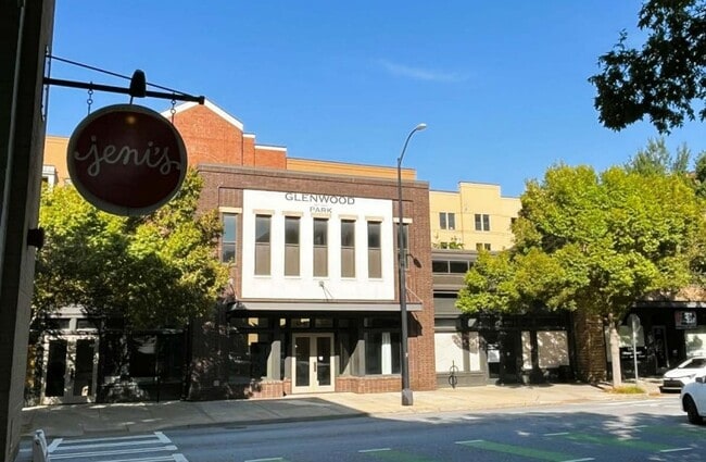
475 Bill Kennedy Way Se
Atlanta-Sandy Springs-Roswell, GA
Glenwood Pk
14-0012-0006-117-3
KA GLENWOOD PK F/C 8/24, UPDATED PHOTO CB 26 TO REMOVE OVR
Storebuilding
Fulton
X
Georgia
13121C0376G
g
2024
0.35 AC
2025
CBD
005000
Atlanta
12,438 SF
DEMOGRAPHICS near 475 Bill Kennedy Way Se
1 Mile
3 Mile
5 Mile
2024 Total Population
18,682
167,371
370,609
2029 Population
19,350
173,006
381,606
Pop Growth 2024-2029
+ 3.58%
+ 3.37%
+ 2.97%
Average Age
37
36
37
2024 Total Households
9,587
78,905
165,696
HH Growth 2024-2029
+ 3.92%
+ 3.67%
+ 3.25%
Median Household Inc
$123,011
$82,156
$77,524
Avg Household Size
1.90
1.90
2.00
2024 Avg HH Vehicles
2.00
1.00
1.00
Median Home Value
$489,271
$455,638
$434,080
Median Year Built
1978
1990
1985
Nearby Places
- Restaurants
- Banks
- Shops
- Fitness
- Groceries
PUBLIC TRANSPORTATION
AIRPORT
Hartsfield - Jackson Atlanta International
DRIVE
WALK
Distance
Hartsfield - Jackson Atlanta International
18 min
10.9 mi
Nearby Properties
Address
Land Use
TOTAL SIZE
Lot Size
Zoning
Address
Land Use
TOTAL SIZE
Lot Size
Zoning
19.94 AC
SPI1
Address
Land Use
TOTAL SIZE
Lot Size
Zoning
1,585,451 SF
1.97 AC
SPI2
Address
Land Use
TOTAL SIZE
Lot Size
Zoning
2,283,599 SF
12.93 AC
I1
Address
Land Use
TOTAL SIZE
Lot Size
Zoning
9.80 AC
C5
Address
Land Use
TOTAL SIZE
Lot Size
Zoning
3.16 AC
SPI1
Address
Land Use
TOTAL SIZE
Lot Size
Zoning
9 AC
C5
Address
Land Use
TOTAL SIZE
Lot Size
Zoning
10.27 AC
C5
Address
Land Use
TOTAL SIZE
Lot Size
Zoning
1,039,831 SF
0.31 AC
C4
Address
Land Use
TOTAL SIZE
Lot Size
Zoning
1,736,017 SF
3.63 AC
SPI2
Address
Land Use
TOTAL SIZE
Lot Size
Zoning
1,300,309 SF
4.81 AC
SPI1
Address
Land Use
TOTAL SIZE
Lot Size
Zoning
1,434,872 SF
1.89 AC
SPI1
Address
Land Use
TOTAL SIZE
Lot Size
Zoning
61.57 AC
C5
Address
Land Use
TOTAL SIZE
Lot Size
Zoning
1.55 AC
SPI1
Address
Land Use
TOTAL SIZE
Lot Size
Zoning
7 AC
C3
Address
Land Use
TOTAL SIZE
Lot Size
Zoning
467,847 SF
1.62 AC
I2
Address
Land Use
TOTAL SIZE
Lot Size
Zoning
1,314,183 SF
2.61 AC
SPI1
Address
Land Use
TOTAL SIZE
Lot Size
Zoning
2,577,342 SF
2.04 AC
SPI1
Address
Land Use
TOTAL SIZE
Lot Size
Zoning
1,121,700 SF
2.21 AC
I2
Address
Land Use
TOTAL SIZE
Lot Size
Zoning
13,340,229 SF
3.68 AC
SPI1
Address
Land Use
TOTAL SIZE
Lot Size
Zoning
0.91 AC
I1
Address
Land Use
TOTAL SIZE
Lot Size
Zoning
1,589,465 SF
3.41 AC
SPI1
Address
Land Use
TOTAL SIZE
Lot Size
Zoning
2,971,832 SF
5.95 AC
SPI2
Address
Land Use
TOTAL SIZE
Lot Size
Zoning
736,752 SF
3.86 AC
C1
Address
Land Use
TOTAL SIZE
Lot Size
Zoning
3.62 AC
SPI1
Address
Land Use
TOTAL SIZE
Lot Size
Zoning
543,748 SF
3.86 AC
I2
Address
Land Use
TOTAL SIZE
Lot Size
Zoning
3,588,720 SF
1.32 AC
SPI1
Address
Land Use
TOTAL SIZE
Lot Size
Zoning
631,858 SF
1.33 AC
C5C
Address
Land Use
TOTAL SIZE
Lot Size
Zoning
766,925 SF
1.73 AC
SPI2
Address
Land Use
TOTAL SIZE
Lot Size
Zoning
1,975,400 SF
9.58 AC
RG4
Address
Land Use
TOTAL SIZE
Lot Size
Zoning
551,866 SF
1.73 AC
SPI2
The World's #1 Commercial Real Estate Marketplace
Connect with us
© 2025 CoStar Group
The information above has been obtained from sources believed reliable. While we do not doubt its accuracy we have not verified it and make no guarantee, warranty or representation about it. It is your responsibility to independently confirm its accuracy and completeness. Any projections, opinions, assumptions, or estimates used are for example only and do not represent the current or future performance of the property. The value of this transaction to you depends on tax and other factors which should be evaluated by your tax, financial, and legal advisors. You and your advisors should conduct a careful, independent investigation of the property to determine to your satisfaction the suitability of the property for your needs.