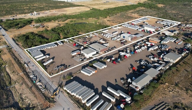
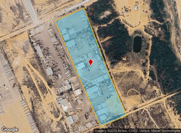
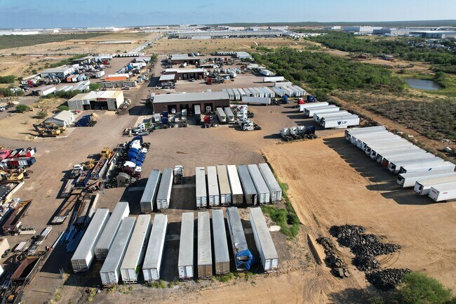
Property Record
475 El Pico Rd, Laredo, TX 78045
NEARBY LISTINGS FOR SALE OR LEASE
Property Detail
475 El Pico Rd
599840
Abst 0056 Porcion 14 J Guajardo
Commercialnec
ABST 56 POR 14 J GUAJARDO 10.751 ACS (TRACT 7)
X
Webb
48479C0850C
Texas
2023
10.75 AC
2025
Texas South Area
0018111004
Other Market Areas
4,800 SF
Laredo, TX
DEMOGRAPHICS near 475 El Pico Rd
1 Mile
3 Mile
5 Mile
2024 Total Population
54
7,736
24,237
2029 Population
55
7,926
24,777
Pop Growth 2024-2029
+ 1.85%
+ 2.46%
+ 2.23%
Average Age
31
31
33
2024 Total Households
14
2,028
6,729
HH Growth 2024-2029
0.00%
+ 2.56%
+ 2.39%
Median Household Inc
$97,499
$82,933
$77,234
Avg Household Size
3.70
3.70
3.50
2024 Avg HH Vehicles
2.00
2.00
2.00
Median Home Value
$221,428
$227,201
$206,963
Median Year Built
2004
2006
2002
Nearby Places
Map Layers
Map Styles
 Street
 Aerial
- Restaurants
- Banks
- Shops
- Fitness
- Groceries
PUBLIC TRANSPORTATION
AIRPORT
Laredo International
DRIVE
WALK
Distance
Laredo International
22 min
14.2 mi
Freight Ports
Port of Corpus Christi
DRIVE
WALK
Distance
Port of Corpus Christi
178 min
153.1 mi
Nearby Properties
Address
Land Use
TOTAL SIZE
Lot Size
Zoning
Address
Land Use
TOTAL SIZE
Lot Size
Zoning
292,914 SF
32.60 AC
Address
Land Use
TOTAL SIZE
Lot Size
Zoning
420,000 SF
25.82 AC
Address
Land Use
TOTAL SIZE
Lot Size
Zoning
240,880 SF
30 AC
Address
Land Use
TOTAL SIZE
Lot Size
Zoning
410,108 SF
33.18 AC
Address
Land Use
TOTAL SIZE
Lot Size
Zoning
48,288 SF
100.18 AC
Address
Land Use
TOTAL SIZE
Lot Size
Zoning
342,583 SF
24.65 AC
Address
Land Use
TOTAL SIZE
Lot Size
Zoning
396,990 SF
24.18 AC
Address
Land Use
TOTAL SIZE
Lot Size
Zoning
309,902 SF
25.69 AC
Address
Land Use
TOTAL SIZE
Lot Size
Zoning
398,259 SF
28.88 AC
Address
Land Use
TOTAL SIZE
Lot Size
Zoning
115,076 SF
32.87 AC
Address
Land Use
TOTAL SIZE
Lot Size
Zoning
379,125 SF
23.83 AC
Address
Land Use
TOTAL SIZE
Lot Size
Zoning
263,842 SF
22.20 AC
Address
Land Use
TOTAL SIZE
Lot Size
Zoning
66,232 SF
47.65 AC
Address
Land Use
TOTAL SIZE
Lot Size
Zoning
162,013 SF
9.16 AC
B1
Address
Land Use
TOTAL SIZE
Lot Size
Zoning
44,474 SF
50 AC
Address
Land Use
TOTAL SIZE
Lot Size
Zoning
98,998 SF
10.31 AC
B3
Address
Land Use
TOTAL SIZE
Lot Size
Zoning
204,070 SF
23.63 AC
Address
Land Use
TOTAL SIZE
Lot Size
Zoning
247,168 SF
15.45 AC
Address
Land Use
TOTAL SIZE
Lot Size
Zoning
11,599 SF
40 AC
M1
Address
Land Use
TOTAL SIZE
Lot Size
Zoning
141,974 SF
16.67 AC
M1
Address
Land Use
TOTAL SIZE
Lot Size
Zoning
140,805 SF
10.79 AC
Address
Land Use
TOTAL SIZE
Lot Size
Zoning
100,710 SF
9.58 AC
Address
Land Use
TOTAL SIZE
Lot Size
Zoning
128,340 SF
7.34 AC
Address
Land Use
TOTAL SIZE
Lot Size
Zoning
97,442 SF
6.45 AC
Address
Land Use
TOTAL SIZE
Lot Size
Zoning
105,164 SF
7.36 AC
Address
Land Use
TOTAL SIZE
Lot Size
Zoning
61,156 SF
22.52 AC
M1
Address
Land Use
TOTAL SIZE
Lot Size
Zoning
95,206 SF
5.91 AC
Address
Land Use
TOTAL SIZE
Lot Size
Zoning
85,410 SF
6.18 AC
M1
Address
Land Use
TOTAL SIZE
Lot Size
Zoning
134,280 SF
6.90 AC
M1
Address
Land Use
TOTAL SIZE
Lot Size
Zoning
128,935 SF
6.50 AC
M1
The World's #1 Commercial Real Estate Marketplace
Connect with us
© 2026 CoStar Group
The information above has been obtained from sources believed reliable. While we do not doubt its accuracy we have not verified it and make no guarantee, warranty or representation about it. It is your responsibility to independently confirm its accuracy and completeness. Any projections, opinions, assumptions, or estimates used are for example only and do not represent the current or future performance of the property. The value of this transaction to you depends on tax and other factors which should be evaluated by your tax, financial, and legal advisors. You and your advisors should conduct a careful, independent investigation of the property to determine to your satisfaction the suitability of the property for your needs.