Property Record
475 Ossipee Trl, Gorham, ME 04038
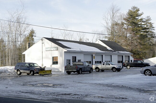

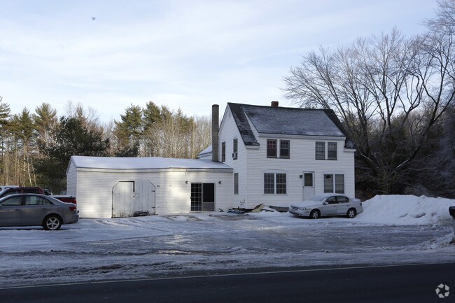
Property Detail
475 Ossipee Trl
Multifamilydwelling
Cumberland
SR
Maine
B and X Area of moderate flood hazard, usually the area between the limits of the 100-year and 500-year floods.
13.50 AC
2025
SW Cumberland County
2025
Portland/South Portland
004100
Portland-South Portland, ME
1,834 SF
GRHM-000076-000021
NEARBY LISTINGS FOR SALE OR LEASE
DEMOGRAPHICS near 475 Ossipee Trl
1 mile
3 mile
5 mile
2024 Total Population
957
5,849
26,462
2029 Population
968
5,919
27,753
Pop Growth 2024-2029
+ 1.15%
+ 1.20%
+ 4.88%
Average Age
39
41
40
2024 Total Households
340
2,218
9,624
HH Growth 2024-2029
+ 1.47%
+ 1.26%
+ 5.02%
Median Household Inc
$110,365
$101,516
$113,296
Avg Household Size
2.80
2.60
2.50
2024 Avg HH Vehicles
2.00
2.00
2.00
Median Home Value
$416,667
$391,518
$447,796
Median Year Built
1988
1981
1990
Nearby Places
Map Layers
Map Styles
 Street
 Aerial
Transit
 Traffic
 Biking
Places
Listings with unknown addresses are not visible on the map
- Restaurants
- Banks
- Shops
- Fitness
- Groceries
PUBLIC TRANSPORTATION
AIRPORT
Portland International Jetport
Drive
Walk
Distance
Portland International Jetport
27 min
14.4 mi
Freight Ports
Portland, ME
Drive
Walk
Distance
Portland, ME
29 min
17.6 mi
Nearby Properties
Address
Land Use
TOTAL SIZE
Lot Size
Zoning
Address
Land Use
TOTAL SIZE
Lot Size
Zoning
2.20 AC
39
Address
Land Use
TOTAL SIZE
Lot Size
Zoning
36,041 SF
17.23 AC
SCD
Address
Land Use
TOTAL SIZE
Lot Size
Zoning
20,971 SF
11 AC
SCD
Address
Land Use
TOTAL SIZE
Lot Size
Zoning
40,038 SF
23 AC
VC
Address
Land Use
TOTAL SIZE
Lot Size
Zoning
134,266 SF
17.02 AC
I
Address
Land Use
TOTAL SIZE
Lot Size
Zoning
11.46 AC
Address
Land Use
TOTAL SIZE
Lot Size
Zoning
6 AC
SCD
Address
Land Use
TOTAL SIZE
Lot Size
Zoning
32 AC
I
Address
Land Use
TOTAL SIZE
Lot Size
Zoning
3,828 SF
25.30 AC
I
Address
Land Use
TOTAL SIZE
Lot Size
Zoning
26,020 SF
17 AC
SCD
Address
Land Use
TOTAL SIZE
Lot Size
Zoning
10,000 SF
6.51 AC
BUXTON
Address
Land Use
TOTAL SIZE
Lot Size
Zoning
5,872 SF
2.61 AC
SCD
Address
Land Use
TOTAL SIZE
Lot Size
Zoning
3,620 SF
1.61 AC
SCD
Address
Land Use
TOTAL SIZE
Lot Size
Zoning
2.10 AC
RC
Address
Land Use
TOTAL SIZE
Lot Size
Zoning
5,794 SF
2.76 AC
SCD
Address
Land Use
TOTAL SIZE
Lot Size
Zoning
2,340 SF
20 AC
RE
Address
Land Use
TOTAL SIZE
Lot Size
Zoning
9,480 SF
10 AC
SCD
Address
Land Use
TOTAL SIZE
Lot Size
Zoning
4,029 SF
1.90 AC
RC
Address
Land Use
TOTAL SIZE
Lot Size
Zoning
8,320 SF
0.93 AC
SCD
Address
Land Use
TOTAL SIZE
Lot Size
Zoning
4,085 SF
2.26 AC
SR
Address
Land Use
TOTAL SIZE
Lot Size
Zoning
2,860 SF
43.44 AC
R
Address
Land Use
TOTAL SIZE
Lot Size
Zoning
3,006 SF
3.51 AC
RC
Address
Land Use
TOTAL SIZE
Lot Size
Zoning
80.72 AC
R
Address
Land Use
TOTAL SIZE
Lot Size
Zoning
1,377 SF
2.26 AC
RC
Address
Land Use
TOTAL SIZE
Lot Size
Zoning
5,208 SF
1.45 AC
SCD
Address
Land Use
TOTAL SIZE
Lot Size
Zoning
2,900 SF
10 AC
RC
Address
Land Use
TOTAL SIZE
Lot Size
Zoning
4,314 SF
1.67 AC
R
Address
Land Use
TOTAL SIZE
Lot Size
Zoning
3,612 SF
5 AC
SR
Address
Land Use
TOTAL SIZE
Lot Size
Zoning
2 AC
VC
Address
Land Use
TOTAL SIZE
Lot Size
Zoning
1,915 SF
0.28 AC
R
The World's #1 Commercial Real Estate Marketplace
Connect with us
© 2026 CoStar Group
The information above has been obtained from sources believed reliable. While we do not doubt its accuracy we have not verified it and make no guarantee, warranty or representation about it. It is your responsibility to independently confirm its accuracy and completeness. Any projections, opinions, assumptions, or estimates used are for example only and do not represent the current or future performance of the property. The value of this transaction to you depends on tax and other factors which should be evaluated by your tax, financial, and legal advisors. You and your advisors should conduct a careful, independent investigation of the property to determine to your satisfaction the suitability of the property for your needs.