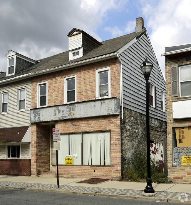
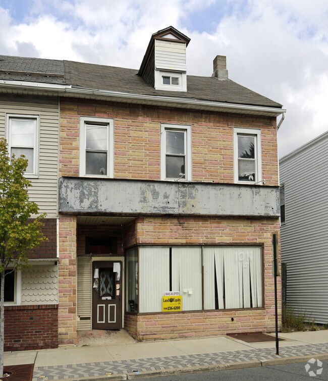
Property Record
475 S Main St, Phillipsburg, NJ 08865

Property Detail
475 S Main St
Allentown-Bethlehem-Easton, PA-NJ
ADDITIONAL LOTS: FIN JUD 03/13/14
19-02003-0000-00012
Warren
Commercialnec
New Jersey
B-4
12
B and X Area of moderate flood hazard, usually the area between the limits of the 100-year and 500-year floods.
0.08 AC
2024
Warren County
2025
Northern New Jersey
030900
NEARBY LISTINGS FOR SALE OR LEASE
DEMOGRAPHICS near 475 S Main St
1 mile
3 mile
5 mile
2025 Total Population
16,516
79,128
123,573
2030 Population
16,799
80,492
125,832
Pop Growth 2025-2030
+ 1.71%
+ 1.72%
+ 1.83%
Average Age
40
40
42
2025 Total Households
6,529
29,817
46,783
HH Growth 2025-2030
+ 1.72%
+ 1.75%
+ 1.90%
Median Household Inc
$67,682
$77,691
$88,825
Avg Household Size
2.40
2.40
2.50
2025 Avg HH Vehicles
2.00
2.00
2.00
Median Home Value
$184,480
$256,391
$299,982
Median Year Built
1948
1951
1965
Nearby Places
Map Layers
Map Styles
 Street
 Aerial
Layers
 Traffic
 Biking
Places
Listings with unknown addresses are not visible on the map
- Restaurants
- Banks
- Shops
- Fitness
- Groceries
PUBLIC TRANSPORTATION
AIRPORT
Lehigh Valley International
Drive
Walk
Distance
Lehigh Valley International
27 min
15.6 mi
Trenton Mercer
Drive
Walk
Distance
Trenton Mercer
71 min
46.0 mi
Freight Ports
Port of Philadelphia
Drive
Walk
Distance
Port of Philadelphia
104 min
63.1 mi
Nearby Properties
Address
Land Use
TOTAL SIZE
Lot Size
Zoning
Address
Land Use
TOTAL SIZE
Lot Size
Zoning
330,000 SF
121.88 AC
R150
Address
Land Use
TOTAL SIZE
Lot Size
Zoning
511,200 SF
66.74 AC
HBRM
Address
Land Use
TOTAL SIZE
Lot Size
Zoning
54.61 AC
Address
Land Use
TOTAL SIZE
Lot Size
Zoning
48.27 AC
I2RA
Address
Land Use
TOTAL SIZE
Lot Size
Zoning
9.80 AC
B-1
Address
Land Use
TOTAL SIZE
Lot Size
Zoning
27.73 AC
RA-7
Address
Land Use
TOTAL SIZE
Lot Size
Zoning
20.65 AC
HBRM
Address
Land Use
TOTAL SIZE
Lot Size
Zoning
15,080 SF
34.28 AC
R120
Address
Land Use
TOTAL SIZE
Lot Size
Zoning
16.54 AC
Address
Land Use
TOTAL SIZE
Lot Size
Zoning
87,508 SF
40.79 AC
CCE
Address
Land Use
TOTAL SIZE
Lot Size
Zoning
47.55 AC
B-3
Address
Land Use
TOTAL SIZE
Lot Size
Zoning
48.60 AC
B-3
Address
Land Use
TOTAL SIZE
Lot Size
Zoning
14.60 AC
RA-7
Address
Land Use
TOTAL SIZE
Lot Size
Zoning
28.79 AC
R-1
Address
Land Use
TOTAL SIZE
Lot Size
Zoning
13,916 SF
9.47 AC
RLD
Address
Land Use
TOTAL SIZE
Lot Size
Zoning
17.06 AC
R-75
Address
Land Use
TOTAL SIZE
Lot Size
Zoning
17.65 AC
I-1
Address
Land Use
TOTAL SIZE
Lot Size
Zoning
127,731 SF
56.29 AC
R12
Address
Land Use
TOTAL SIZE
Lot Size
Zoning
7.43 AC
R-50
Address
Land Use
TOTAL SIZE
Lot Size
Zoning
37.18 AC
I
Address
Land Use
TOTAL SIZE
Lot Size
Zoning
43.49 AC
B-3
Address
Land Use
TOTAL SIZE
Lot Size
Zoning
15.02 AC
ROM
Address
Land Use
TOTAL SIZE
Lot Size
Zoning
5,600 SF
24.18 AC
B-I
Address
Land Use
TOTAL SIZE
Lot Size
Zoning
6,966 SF
8.86 AC
RMD
Address
Land Use
TOTAL SIZE
Lot Size
Zoning
7.21 AC
B-3
Address
Land Use
TOTAL SIZE
Lot Size
Zoning
21.72 AC
R-3B
Address
Land Use
TOTAL SIZE
Lot Size
Zoning
20.75 AC
B-1
Address
Land Use
TOTAL SIZE
Lot Size
Zoning
0.67 AC
B-I
Address
Land Use
TOTAL SIZE
Lot Size
Zoning
84,805 SF
12.20 AC
CHDD
Address
Land Use
TOTAL SIZE
Lot Size
Zoning
12.16 AC
The World's #1 Commercial Real Estate Marketplace
Connect with us
© 2026 CoStar Group
The information above has been obtained from sources believed reliable. While we do not doubt its accuracy we have not verified it and make no guarantee, warranty or representation about it. It is your responsibility to independently confirm its accuracy and completeness. Any projections, opinions, assumptions, or estimates used are for example only and do not represent the current or future performance of the property. The value of this transaction to you depends on tax and other factors which should be evaluated by your tax, financial, and legal advisors. You and your advisors should conduct a careful, independent investigation of the property to determine to your satisfaction the suitability of the property for your needs.