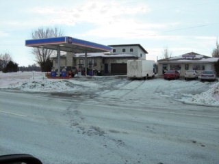
Property Record
475 State Route 11, Champlain, NY 12919

Property Detail
475 State Route 11
Plattsburgh, NY
LOT 106 REF TRACK PATENT
092889-019-000-0001-044-002-0000
Clinton
Warehouse
New York
B and X Area of moderate flood hazard, usually the area between the limits of the 100-year and 500-year floods.
44.002
2025
1 AC
2025
Champlain
100101
Other Market Areas
2,112 SF
NEARBY LISTINGS FOR SALE OR LEASE
DEMOGRAPHICS near 475 State Route 11
1 mile
3 mile
5 mile
2025 Total Population
181
4,386
5,497
2030 Population
177
4,320
5,422
Pop Growth 2025-2030
(2.21%)
(1.50%)
(1.36%)
Average Age
43
44
44
2025 Total Households
79
2,010
2,458
HH Growth 2025-2030
(1.27%)
(1.54%)
(1.46%)
Median Household Inc
$76,136
$53,277
$57,240
Avg Household Size
2.30
2.20
2.20
2025 Avg HH Vehicles
2.00
2.00
2.00
Median Home Value
$167,187
$175,452
$183,558
Median Year Built
1963
1965
1967
Nearby Places
Map Layers
Map Styles
 Street
 Aerial
Layers
 Traffic
 Biking
Places
Listings with unknown addresses are not visible on the map
- Restaurants
- Banks
- Shops
- Fitness
- Groceries
PUBLIC TRANSPORTATION
COMMUTER RAIL
Drive
Walk
Distance
4 min
3.4 mi
AIRPORT
Plattsburgh International
Drive
Walk
Distance
Plattsburgh International
35 min
26.7 mi
Freight Ports
Montreal
Drive
Walk
Distance
Montreal
65 min
47.1 mi
Nearby Properties
Address
Land Use
TOTAL SIZE
Lot Size
Zoning
Address
Land Use
TOTAL SIZE
Lot Size
Zoning
15.40 AC
Address
Land Use
TOTAL SIZE
Lot Size
Zoning
174,431 SF
77.40 AC
Address
Land Use
TOTAL SIZE
Lot Size
Zoning
24,618 SF
5.80 AC
Address
Land Use
TOTAL SIZE
Lot Size
Zoning
23,178 SF
24.70 AC
01 - NOT Z
Address
Land Use
TOTAL SIZE
Lot Size
Zoning
Address
Land Use
TOTAL SIZE
Lot Size
Zoning
28,764 SF
22.60 AC
01 - NOT Z
Address
Land Use
TOTAL SIZE
Lot Size
Zoning
10.10 AC
Address
Land Use
TOTAL SIZE
Lot Size
Zoning
Address
Land Use
TOTAL SIZE
Lot Size
Zoning
12,960 SF
13.80 AC
Address
Land Use
TOTAL SIZE
Lot Size
Zoning
Address
Land Use
TOTAL SIZE
Lot Size
Zoning
91,440 SF
9.80 AC
Address
Land Use
TOTAL SIZE
Lot Size
Zoning
0.51 AC
Address
Land Use
TOTAL SIZE
Lot Size
Zoning
100,000 SF
9.54 AC
Address
Land Use
TOTAL SIZE
Lot Size
Zoning
29,085 SF
17.60 AC
Address
Land Use
TOTAL SIZE
Lot Size
Zoning
37,809 SF
1.20 AC
05
Address
Land Use
TOTAL SIZE
Lot Size
Zoning
Address
Land Use
TOTAL SIZE
Lot Size
Zoning
100,000 SF
11.60 AC
Address
Land Use
TOTAL SIZE
Lot Size
Zoning
6.94 AC
Address
Land Use
TOTAL SIZE
Lot Size
Zoning
270,700 SF
18.80 AC
Address
Land Use
TOTAL SIZE
Lot Size
Zoning
5,890 SF
2.60 AC
Address
Land Use
TOTAL SIZE
Lot Size
Zoning
2.94 AC
Address
Land Use
TOTAL SIZE
Lot Size
Zoning
19,000 SF
5.84 AC
Address
Land Use
TOTAL SIZE
Lot Size
Zoning
134,400 SF
11.60 AC
Address
Land Use
TOTAL SIZE
Lot Size
Zoning
37.22 AC
Address
Land Use
TOTAL SIZE
Lot Size
Zoning
27.50 AC
01
Address
Land Use
TOTAL SIZE
Lot Size
Zoning
380.60 AC
Address
Land Use
TOTAL SIZE
Lot Size
Zoning
71,500 SF
5.50 AC
01 - NOT Z
Address
Land Use
TOTAL SIZE
Lot Size
Zoning
64,000 SF
3.17 AC
01 - NOT Z
Address
Land Use
TOTAL SIZE
Lot Size
Zoning
59,916 SF
17.20 AC
05
Address
Land Use
TOTAL SIZE
Lot Size
Zoning
50,000 SF
11.42 AC
The World's #1 Commercial Real Estate Marketplace
Connect with us
© 2026 CoStar Group
The information above has been obtained from sources believed reliable. While we do not doubt its accuracy we have not verified it and make no guarantee, warranty or representation about it. It is your responsibility to independently confirm its accuracy and completeness. Any projections, opinions, assumptions, or estimates used are for example only and do not represent the current or future performance of the property. The value of this transaction to you depends on tax and other factors which should be evaluated by your tax, financial, and legal advisors. You and your advisors should conduct a careful, independent investigation of the property to determine to your satisfaction the suitability of the property for your needs.