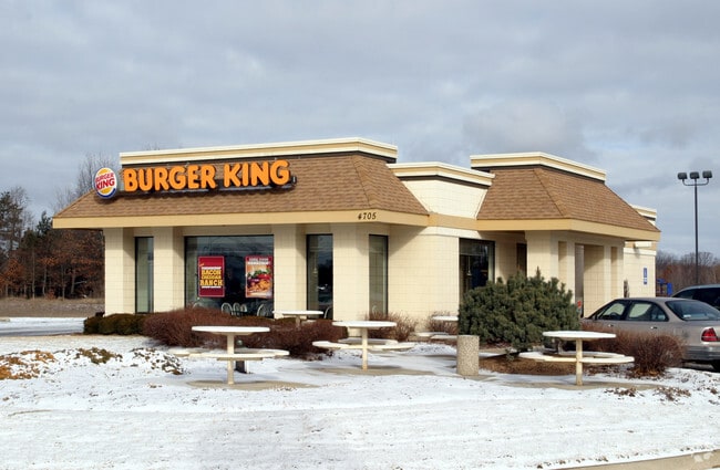
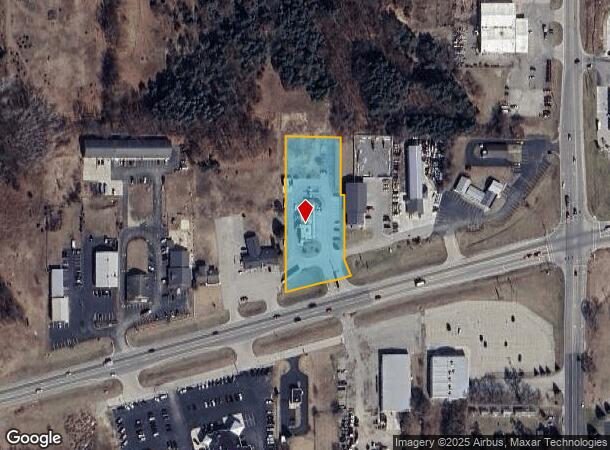
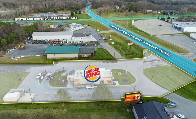
Property Record
4705 14 Mile Rd Ne, Rockford, MI 49341
NEARBY LISTINGS FOR SALE OR LEASE
Property Detail
4705 14 Mile Rd Ne
41-06-12-476-008
PART OF SE 1/4 COM AT E 1/4 COR TH S 0D 00M 18S E ALONG E SEC LINE 1319.11 FT TO S 1/8 LINE TH N 89D 15M 26S W ALONG S 1/8
Commercialnec
Kent
X
Michigan
26081C0195D
1.62 AC
2024
Outlying Kent County
2025
West Michigan
010602
Grand Rapids-Wyoming, MI
2,095 SF
DEMOGRAPHICS near 4705 14 Mile Rd Ne
1 Mile
3 Mile
5 Mile
2024 Total Population
1,425
10,433
32,656
2029 Population
1,445
10,570
33,114
Pop Growth 2024-2029
+ 1.40%
+ 1.31%
+ 1.40%
Average Age
39
39
39
2024 Total Households
489
3,645
11,738
HH Growth 2024-2029
+ 1.43%
+ 1.29%
+ 1.41%
Median Household Inc
$122,499
$103,974
$94,978
Avg Household Size
2.90
2.80
2.80
2024 Avg HH Vehicles
2.00
2.00
2.00
Median Home Value
$293,683
$277,608
$276,292
Median Year Built
1992
1993
1992
Nearby Places
Map Layers
Map Styles
 Street
 Aerial
- Restaurants
- Banks
- Shops
- Fitness
- Groceries
PUBLIC TRANSPORTATION
AIRPORT
Gerald R Ford International
DRIVE
WALK
Distance
Gerald R Ford International
40 min
26.1 mi
SALE & LEASE HISTORY
LISTING DATE
SALE/LEASE

Dec 15, 2020
For Sale
Nearby Properties
Address
Land Use
TOTAL SIZE
Lot Size
Zoning
Address
Land Use
TOTAL SIZE
Lot Size
Zoning
413,330 SF
20.83 AC
I-1
Address
Land Use
TOTAL SIZE
Lot Size
Zoning
40,800 SF
109.96 AC
IC
Address
Land Use
TOTAL SIZE
Lot Size
Zoning
Address
Land Use
TOTAL SIZE
Lot Size
Zoning
99.87 AC
R4
Address
Land Use
TOTAL SIZE
Lot Size
Zoning
13,955 SF
196.11 AC
MHP
Address
Land Use
TOTAL SIZE
Lot Size
Zoning
64,075 SF
11.13 AC
I-1
Address
Land Use
TOTAL SIZE
Lot Size
Zoning
3,400 SF
8.59 AC
C2
Address
Land Use
TOTAL SIZE
Lot Size
Zoning
36,324 SF
8.29 AC
C2
Address
Land Use
TOTAL SIZE
Lot Size
Zoning
8.86 AC
C2
Address
Land Use
TOTAL SIZE
Lot Size
Zoning
Address
Land Use
TOTAL SIZE
Lot Size
Zoning
66,590 SF
4.06 AC
I-1
Address
Land Use
TOTAL SIZE
Lot Size
Zoning
Address
Land Use
TOTAL SIZE
Lot Size
Zoning
49,647 SF
5.30 AC
I-1
Address
Land Use
TOTAL SIZE
Lot Size
Zoning
68,724 SF
7.53 AC
I-1
Address
Land Use
TOTAL SIZE
Lot Size
Zoning
64,632 SF
3.75 AC
I-1
Address
Land Use
TOTAL SIZE
Lot Size
Zoning
1,400 SF
60 AC
I-1
Address
Land Use
TOTAL SIZE
Lot Size
Zoning
54,186 SF
3.17 AC
I-1
Address
Land Use
TOTAL SIZE
Lot Size
Zoning
23,280 SF
Address
Land Use
TOTAL SIZE
Lot Size
Zoning
56,500 SF
5.94 AC
I-1
Address
Land Use
TOTAL SIZE
Lot Size
Zoning
3.56 AC
C2
Address
Land Use
TOTAL SIZE
Lot Size
Zoning
24,800 SF
3.90 AC
Address
Land Use
TOTAL SIZE
Lot Size
Zoning
16,000 SF
9.83 AC
Address
Land Use
TOTAL SIZE
Lot Size
Zoning
572 SF
16.47 AC
R-4
Address
Land Use
TOTAL SIZE
Lot Size
Zoning
Address
Land Use
TOTAL SIZE
Lot Size
Zoning
8,684 SF
3.54 AC
Address
Land Use
TOTAL SIZE
Lot Size
Zoning
14,653 SF
1.80 AC
H-C
Address
Land Use
TOTAL SIZE
Lot Size
Zoning
31,843 SF
3.48 AC
C2
Address
Land Use
TOTAL SIZE
Lot Size
Zoning
Address
Land Use
TOTAL SIZE
Lot Size
Zoning
13,520 SF
Address
Land Use
TOTAL SIZE
Lot Size
Zoning
The World's #1 Commercial Real Estate Marketplace
Connect with us
© 2025 CoStar Group
The information above has been obtained from sources believed reliable. While we do not doubt its accuracy we have not verified it and make no guarantee, warranty or representation about it. It is your responsibility to independently confirm its accuracy and completeness. Any projections, opinions, assumptions, or estimates used are for example only and do not represent the current or future performance of the property. The value of this transaction to you depends on tax and other factors which should be evaluated by your tax, financial, and legal advisors. You and your advisors should conduct a careful, independent investigation of the property to determine to your satisfaction the suitability of the property for your needs.