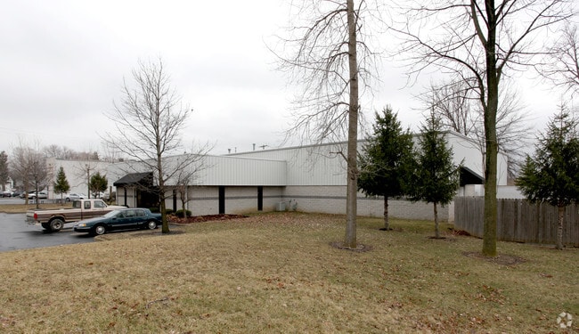
Property Record
4751 Poth Rd, Columbus, OH 43213

Property Detail
4751 Poth Rd
090-008263
GRANVILLE ROAD R21 T12 S4 1/4S4 1.376 ACRES
Storemultistory
Franklin
B and X Area of moderate flood hazard, usually the area between the limits of the 100-year and 500-year floods.
Ohio
2024
1.37 AC
2025
Airport
009251
Columbus
11,382 SF
Columbus, OH
NEARBY LISTINGS FOR SALE OR LEASE
DEMOGRAPHICS near 4751 Poth Rd
1 mile
3 mile
5 mile
2025 Total Population
8,356
85,360
261,727
2030 Population
8,692
87,760
270,209
Pop Growth 2025-2030
+ 4.02%
+ 2.81%
+ 3.24%
Average Age
38
39
38
2025 Total Households
3,936
35,635
105,710
HH Growth 2025-2030
+ 4.01%
+ 2.94%
+ 3.43%
Median Household Inc
$48,339
$54,808
$60,070
Avg Household Size
2.10
2.30
2.40
2025 Avg HH Vehicles
1.00
2.00
2.00
Median Home Value
$178,292
$235,868
$263,076
Median Year Built
1973
1968
1974
Nearby Places
Map Layers
Map Styles
 Street
 Aerial
Transit
 Traffic
 Biking
Places
Listings with unknown addresses are not visible on the map
- Restaurants
- Banks
- Shops
- Fitness
- Groceries
PUBLIC TRANSPORTATION
AIRPORT
John Glenn Columbus International
Drive
Walk
Distance
John Glenn Columbus International
8 min
3.3 mi
Rickenbacker International
Drive
Walk
Distance
Rickenbacker International
25 min
15.2 mi
SALE & LEASE HISTORY
LISTING DATE
SALE/LEASE

Oct 07, 2022
For Sale
Jun 06, 2023
For Lease
Nearby Properties
Address
Land Use
TOTAL SIZE
Lot Size
Zoning
Address
Land Use
TOTAL SIZE
Lot Size
Zoning
316,415 SF
415.78 AC
Address
Land Use
TOTAL SIZE
Lot Size
Zoning
1,256,678 SF
1,292.62 AC
Address
Land Use
TOTAL SIZE
Lot Size
Zoning
Address
Land Use
TOTAL SIZE
Lot Size
Zoning
761,542 SF
21.30 AC
Address
Land Use
TOTAL SIZE
Lot Size
Zoning
180,383 SF
15.54 AC
Address
Land Use
TOTAL SIZE
Lot Size
Zoning
208,472 SF
1.45 AC
Address
Land Use
TOTAL SIZE
Lot Size
Zoning
329,049 SF
38.53 AC
Address
Land Use
TOTAL SIZE
Lot Size
Zoning
164,095 SF
33.71 AC
Address
Land Use
TOTAL SIZE
Lot Size
Zoning
147,649 SF
5.15 AC
Address
Land Use
TOTAL SIZE
Lot Size
Zoning
122,526 SF
27 AC
Address
Land Use
TOTAL SIZE
Lot Size
Zoning
514,341 SF
46.79 AC
Address
Land Use
TOTAL SIZE
Lot Size
Zoning
183,352 SF
55.41 AC
Address
Land Use
TOTAL SIZE
Lot Size
Zoning
282,035 SF
29.29 AC
Address
Land Use
TOTAL SIZE
Lot Size
Zoning
464,796 SF
7.33 AC
Address
Land Use
TOTAL SIZE
Lot Size
Zoning
166,628 SF
9.98 AC
Address
Land Use
TOTAL SIZE
Lot Size
Zoning
706,471 SF
41.34 AC
Address
Land Use
TOTAL SIZE
Lot Size
Zoning
217,088 SF
10.67 AC
Address
Land Use
TOTAL SIZE
Lot Size
Zoning
253,893 SF
12.57 AC
Address
Land Use
TOTAL SIZE
Lot Size
Zoning
171,366 SF
28.27 AC
Address
Land Use
TOTAL SIZE
Lot Size
Zoning
1,264,151 SF
58.42 AC
Address
Land Use
TOTAL SIZE
Lot Size
Zoning
170,209 SF
15.03 AC
Address
Land Use
TOTAL SIZE
Lot Size
Zoning
142,542 SF
6.55 AC
Address
Land Use
TOTAL SIZE
Lot Size
Zoning
188,305 SF
27.46 AC
Address
Land Use
TOTAL SIZE
Lot Size
Zoning
142,542 SF
3.95 AC
Address
Land Use
TOTAL SIZE
Lot Size
Zoning
158,325 SF
34.39 AC
Address
Land Use
TOTAL SIZE
Lot Size
Zoning
187,858 SF
19.50 AC
Address
Land Use
TOTAL SIZE
Lot Size
Zoning
145,592 SF
4.48 AC
Address
Land Use
TOTAL SIZE
Lot Size
Zoning
102,412 SF
11.86 AC
Address
Land Use
TOTAL SIZE
Lot Size
Zoning
267,596 SF
5.76 AC
Address
Land Use
TOTAL SIZE
Lot Size
Zoning
471,738 SF
35.43 AC
The World's #1 Commercial Real Estate Marketplace
Connect with us
© 2026 CoStar Group
The information above has been obtained from sources believed reliable. While we do not doubt its accuracy we have not verified it and make no guarantee, warranty or representation about it. It is your responsibility to independently confirm its accuracy and completeness. Any projections, opinions, assumptions, or estimates used are for example only and do not represent the current or future performance of the property. The value of this transaction to you depends on tax and other factors which should be evaluated by your tax, financial, and legal advisors. You and your advisors should conduct a careful, independent investigation of the property to determine to your satisfaction the suitability of the property for your needs.